

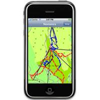
Navionics Chart Support Added to iPhone
Software manufacturer Northport Systems Inc. announced that its popular Fugawi X-Traverse online map collection for use with iNavX marine software for the Apple iPhone now supports Navionics marine and outdoor charts. Adding to iNavX’s support of raster maps including NOAA RNC, Swedish Marine Charts, and TRAK Maps, users now have subscription-based, fingertip access to world-wide Navionics Gold+ international marine, HotMaps Premium North American fishing and European Discovery outdoor charts from www.X-Traverse.com. Navionics charts are downloaded directly into iNavX software through the iPhone’s internet connection (Edge, 3G or WiFi) and saved locally on the phone for use when outside of cell phone or WiFi internet coverage.
Navionics Free iPhone Mobile
Navionics, electronic cartography and navigation data supply, announces the availability of its free application for iPhone users, Navionics Viewer, which includes fully-functional marine navigation charts for Southeastern Florida, as well as marine and outdoor cartography for Genoa, Italy. Navionics Viewer, with the free cartography samples, allow you to see your GPS position, tap and pinch the screen to zoom in and out, scroll the chart seamlessly, query chart objects, find your favorite marina, adjust depth units, and view in day or night mode.
Furuno Unveils Navnet VX2
Furuno USA introduced its latest innovation in integrated marine electronics, NavNet vx2. Since its release in 2001, Furuno’s NavNet1 series has been enjoying popularity worldwide for its high reliability, performance and expandability. NavNet1 uses an Ethernet based network to transfer information throughout the components. NavNet vx2 still utilizes an Ethernet network and even expands upon it to give you more options to connect and interact with a PC. Add multiple displays and components onto the network by simply adding an Ethernet Hub. NavNet vx2 gives the user their choice of cartography. Users can choose from a unit that accepts Navionics Gold XL3 charts or another model utilizing C-MapNT Max charts, both of which are now on Secure Digital (SD) cards.


