

Consolidation is King – Tidewater and Swire Pacific Offshore
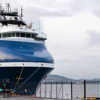
Tongues are wagging in the offshore sector, as one of the longest-running rumors in the market has finally come true. U.S. offshore vessel owner Tidewater Marine has acquired Singapore's Swire Pacific Offshore for USD 190 million, the company’s biggest powerplay since its acquisition of GulfMark Offshore back in 2018.But why SPO, and why now? In this article, VesselsValue's Head of Offshore, Rob Day, seeks to answer these questions and provide commentary on why this long-time…
Saab Supplies First Common Operating Picture to Flinders Ports
Defence and security company Saab has deployed its first Common Operating Picture (COP): an extension of Saab’s KleinPort port management information system (PMIS) that makes ports more efficient and competitive. As of November 1st 2016, Flinders Ports in Australia began live utilization of the KleinPort COP. KleinPort COP gives all authorized port stakeholders an easily accessible, map-based overview of their port. The information is layered to allow users to select only the data relevant to their area of responsibility.
Cambla Launches Upgraded Technology to Renewables Market
International project services consultancy, Cambla, has launched an upgraded version of its Schedule Animation Tool (S.A.T) to the renewables market. Initially launched to market last year, the technology was a world-first for the oil and gas industry and has been further developed to ensure effective and efficient planning of renewable marine operations. S.A.T provides an accurate visual representation of vessel locations and planned activities, offering project teams full fleet management support and significant cost savings. The most recent upgrades to the tool significantly improve user experience and include improved comparison view, detailed project infrastructure and the addition of renewable graphics.
CargoSmart Launches Big Schedules Search Engine
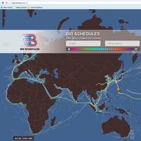
CargoSmart Limited, a global shipment management software solutions provider that leverages big data for greater visibility and benchmarking, has announced Big Schedules, a new sailing schedule search platform that helps shippers and logistics service providers manage and visualize their ocean routes. Big Schedules actively sources ocean carriers’ published sailing schedules and live vessel location data in order to provide personalized search results for faster and greater insights to improve their shipment planning. The new, free sailing schedule search engine is available on the website.
PortVision Brings Advanced Marine Vessel-Tracking

Capabilities to Latest Full-Featured Smartphones. PortVision Vessel-Tracking Service, Terminal and Fleet Management Dashboards, and Other Capabilities Now Available in Platform Optimized for iPhone, Android, and BlackBerry Devices. PortVision, a provider of business intelligence solutions for the maritime industry, today announced that the company’s desktop Automatic Identification System (AIS) vessel-tracking service is now available in a mobile platform that has been optimized for today’s full-featured smartphones including BlackBerry, iPhone and Android devices.
AIS Vessel-tracking by Smartphone
PortVision vessel-tracking service, terminal and fleet management dashboards, & other capabilities is now available in platform optimized for iPhone, Android, and BlackBerry devices. The company’s latest mobile platform is available now, at no cost, to PortVision customers who subscribe to its PortVision Plus, PortVision Advantage, TerminalSmart™ and Fleet Management System offerings. “Our latest mobile platform delivers on our vision of giving PortVision users all the information they need to manage their maritime domain, no matter where they are,” said Dean Rosenberg, PortVision chief executive officer. The new PortVision Mobile 2.0 platform adds a number of capabilities based on extensive feedback from the company’s active mobile users.
AIS Satellite Launch Date Set
The highest detection performance Automatic Identification System (AIS) satellite ever built, will be launched by a Soyuz launch vehicle from the Baikonur Cosmodrome in Kazakhstan on on 22nd July 2012. AIS is currently deployed on more than 80,000 vessels globally, however AIS base station receivers are mostly based on land and can only track ships moving up to 50 nautical miles off the coast. exactEarth is pioneering space-based AIS services that increases the range, enabling the monitoring of vessels throughout the World’s oceans. exactView-1 (previously known as ADS-1b) was built under contract for exactEarth and will become the fifth deployed satellite in exactEarth’s advanced vessel monitoring satellite constellation.
PortVision: A Helping Hand in the Deepwater Horizon Response
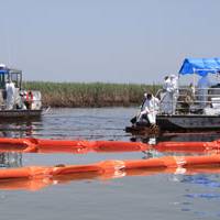
MarineNews spoke with Dean Rosenberg, CEO of PortVision, about the company’s role in the coordination of the Deepwater Horizon spill response in the Gulf of Mexico. PortVision is a web-based service that uses data from the Automated Identification System (AIS), mandated by the IMO and the U.S. Coast Guard, to provide shore-side users with real-time vessel tracking as well as historical reporting. “The main purpose for AIS, why it was mandated, is for collision avoidance,” Rosenberg said.
PortVision Introduces TerminalSmart
PortVision, provider of business intelligence solutions for the maritime industry, announced its web-based service platform integrating vessel tracking, management and analysis in a single, operational dashboard for marine terminal operators. The TerminalSmart solution gives terminal operators access to PortVision’s comprehensive database of both real-time and historical vessel movements based on AIS vessel-tracking data, and combines it with management, analysis and reporting tools to enhance terminal operations. Unlike stand-alone AIS-based tracking tools that simply display dots on a map to represent current vessel locations, TerminalSmart is a comprehensive real-time and historical vessel tracking, management and analysis platform.
UNOSAT 3D Map of Piracy in Gulf of Aden
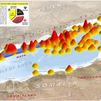
UNOSAT, the UN Institute for Training and Research (UNITAR) Operational Satellite Applications Program, released a 3D map of piracy incidents in the Gulf of Aden for 2008. This 3D perspective map illustrates the relative spatial density of reported pirate incidents in the Gulf of Aden for 2008, current as of 21 November. Incidents that have occurred within 5km of the Maritime Security Patrol Area (MSPA) following implementation on 26 August 2008 are identified. A spatial analysis of the pattern changes in attacks has also been conducted.


