NOAA Aerial Mapping Assists Katrina Clean Up

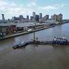
The NOAA Office of Response and Restoration is working closely with FEMA and the U.S. Coast Guard in coordinating the response to hazardous materials in the flood waters of New Orleans and with the continuing search and rescue mission in response to the aftermath of Hurricane Katrina.
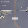
One of the innovative technologies being applied is combining LIDAR (airborne laser used to measure topography) and aerial satellite imagery to create aerial maps of the region. NOAA is assisting in tracking the progress in removing water from the flooded areas of the region by providing aerial maps showing the progress to date.
The maps (pictured) are generated using satellite imagery acquired from the Department of Defense National Geospatial Intelligence Agency combined with LIDAR (Light Detection and Ranging) data from Louisiana State University and the State of Louisiana. Research Planning Inc., a NOAA contractor, is conducting this synthesis that shows likely water depths based on the combination of data.