NOAA to Evaluate and Assess Region

Photo Credit: NOAA
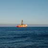
An aerial image of south Plaquemines Parish, La., near Empire, Buras and Boothville, where Hurricane Katrina made landfall on August 29, 2005 as a Category Four hurricane with maximum winds estimated at 140 mph to the east of the center. The NOAA Office of Response and Restoration and Damage Assessment Center is deploying NOAA scientists and other specialists—in coordination with federal, state and local emergency centers—to assist in evaluating the damages to the many oil and chemical pipelines and platforms in the region.
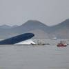
An aerial image of south Plaquemines Parish, La., near Empire, Buras and Boothville, where Hurricane Katrina made landfall on August 29, 2005 as a Category Four hurricane with maximum winds estimated at 140 mph to the east of the center. The NOAA Office of Response and Restoration and Damage Assessment Center is deploying NOAA scientists and other specialists—in coordination with federal, state and local emergency centers—to assist in evaluating the damages to the many oil and chemical pipelines and platforms in the region.