UNOSAT 3D Map of Piracy in Gulf of Aden
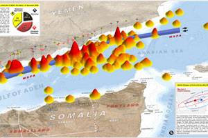
UNOSAT, the UN Institute for Training and Research (UNITAR) Operational Satellite Applications Program, released a 3D map of piracy incidents in the Gulf of Aden for 2008. This 3D perspective map illustrates the relative spatial density of reported pirate incidents in the Gulf of Aden for 2008, current as of 21 November. Incidents that have occurred within 5km of the Maritime Security Patrol Area (MSPA) following implementation on 26 August 2008 are identified. A spatial analysis of the pattern changes in attacks has also been conducted. Satellite imagery has been used in this analysis for the identification of suspected hijacked vessel locations, and to identify vessel traffic patterns through the Gulf of Aden.
This work was done by UNOSAT in support of the ongoing humanitarian operations across the Horn of Africa, and in response to the UN Security Council Resolution 1816 (2008) adopted 2 June 2008, and IMO resolution adopted 29 Nov. 2007 calling for continued monitoring of Somali pirate activity. All piracy incident data has been obtained from open media sources, specifically the Piracy Reporting Center (PRC) of the International Maritime Bureau (IMB).
Incidents are classified into 3 main types: ´Hijacking´ where pirates have taken control of a ship; ´Attempted Hijacking´ where pirates have deployed weapons & attempted to board a vessel but failed; ´Suspicious Approach´ where a vessel has followed or chased another ship; Note, a number of reported ´Suspicious Approach´ incidents may represent accidental vessel approaches misperceived as a pirate threat. This is an initial assessment and has not been independently verified.
(http://unosat.web.cern.ch/unosat/)


