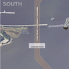
NOAA Updates Cobscook Bay Area Chart

Northern Maine vessels will be able to navigate more safely around the dangerous Cobscook Bay thanks to an updated version of the area's nautical chart issued by NOAA. The latest chart includes a new detailed illustration-called a "chart inset"-of the waters around Falls Island, providing safer passage for mariners who transit those waters.
While NOAA cartographers had updated Chart 13394 (Grand Manan Channel) over the past several years, using depth measurements and obstruction locations acquired during a major hydrographic survey in 2010, a new inset was needed specifically for Falls Island.
"Larger, more detailed scale coverage helps mitigate the dangers to navigation in these areas," explained Cmdr. Shep Smith, chief of NOAA Office of Coast Survey's Marine Chart Division. "This new inset provides even more detail for the waters west of Cobscook Bay, where fishing vessels encounter some of the earth's highest tidal ranges, powerful currents and treacherous conditions."
The inset hydrographic data was acquired by a NOAA Coast Survey navigation response team that conducted a full bottom survey in the Bay from June to October 2010, at the request of the area fishing community and U.S. Senators Olympia Snowe and Susan Collins.
The inset also has updated shoreline depictions, acquired by aerial photography from NOAA National Geodetic Survey's Remote Sensing Division in 2011.
The new inset, called Falls Island, is created on a 1:20,000 scale and shows significant detail. Chart 13394, Grand Manan Channel (Northern Part), was first published in 1992. Prior nautical charts of Cobscook Bay go back to the 19th century, when the U.S. Coast and Geodetic Survey, NOAA's predecessor organization, first began its survey of Maine in 1863 and published the nautical chart Eastport to Moose Cove in 1893.
The new edition of Chart 13394 became available September 3 as a Print on Demand chart and a NOAA Raster Navigational Chart (NOAA RNC). Traditional paper charts will be available for purchase from chart vendors in October. The NOAA Electronic Navigational Chart (NOAA ENC) will be available for download in October as well. The main ENC cell is US5ME55, the inset cell will be US5ME53.
noaa.gov