Redwood City Proposes Port Deepening Project


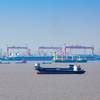
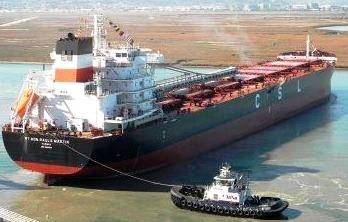
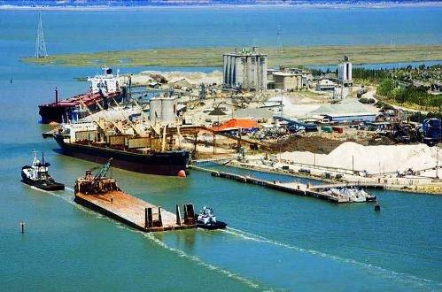 Photo: Port of Redwood City
 Photo: Port of Redwood City

Recommended $73 Million Plan for Redwood City Navigation Improvement Program; Public Hearing Set for August 10
A recommended $73 million plan to deepen the Redwood City Harbor and San Bruno Shoal channels, the navigation corridors essential for commerce and the Port of Redwood City, has been issued in draft by the U.S. Army Corp of Engineers' San Francisco District. The draft called the plan "technically sound, economically justified, and socially and environmentally acceptable."
The port is conducting a public hearing on what is called the "Redwood City Navigation Improvement Project" August 10 at 7 p.m. at Redwood City Hall to allow public comment and recommendations on the project's Draft Feasibility Study and Environment Impact Statement/Environmental Impact Report.
The draft recommended plan consists of deepening the Redwood City Harbor (known as Redwood Creek until 1949) and San Bruno Shoal Channels from -30 feet MLLW to -32 feet MLLW and slightly realigning the Redwood City Harbor channel to avoid sensitive environmental features of Bair and Greco Islands.
According to the port, the recommended plan maximizes net national economic development benefits and was identified in the Draft Feasibility Study as the "National Economic Development Plan." The recommended plan avoids adverse environmental impacts to the maximum extent practicable and includes mitigation measures to offset impacts when necessary.
Analysis of the impacts of channel deepening determined that a slight realignment of the RWC Channel was necessary to avoid or minimize impacts to adjacent tidal mudflats. The current alignment of the channel near the entrance closely follows the border of outer Bair Island. The realignment would slightly shift the channel (approximately 6 feet) in an easterly direction away from outer Bair Island.
The purpose of the Redwood City Harbor Navigation Study is to evaluate alternatives for improving the efficiency of navigation to the Port. This document was prepared by the USACE, San Francisco District, in collaboration with the Port of Redwood City. The purpose of the DEIS/DEIR is to evaluate the potential significant environmental impacts of the alternatives proposed in the feasibility study. The integrated DEIS/DEIR will be used to support Congressional authorization of the recommended plan for improvements to the Redwood City Harbor Navigation Project.
Redwood City Harbor is located on the southwest side of San Francisco Bay, approximately 18 miles south of San Francisco. It is within the corporate limits of Redwood City.
The study area includes the existing federal navigation channel and turning basins at Redwood City Harbor, extending from the mouth of Redwood Creek to deep water in the San Francisco Bay. The federal navigation channel at San Bruno Shoal in San Francisco Bay is also included in the study area, having been added to the federal project by the 1945 authorizing legislation. It is located north of Redwood City and lies within the corporate boundaries of the cities of both Brisbane and South San Francisco.
The recommended plan would dredge 1.4 million cubic yards and be disposed at the San Francisco Deep Ocean Disposal Site (SFDODS), which is also part of the study area but is located in the Pacific Ocean about 50 miles offshore from the Golden Gate Bridge and 85 nautical miles from the Port of Redwood City.
According to the Feasibility Study's section entitled "Need for Action," the major problem at Redwood City Harbor is transportation cost inefficiencies.
"The existing navigation project channels at Redwood City Harbor and San Bruno Shoals do not allow for the efficient operation of the vessel fleet that calls on the Port," according to the report. "Seventy percent of vessels calling on the Port have design drafts that are greater than the authorized channel depth of -30 feet MLLW. Having to wait for favorable tide is inefficient, requiring the practices of light loading or lightering to larger vessels and waiting for favorable tide conditions in order to access the Port."
"Three classes of commercial vessels call on the Port: Handysize, Handymax, and Panamax vessels. The design drafts for these vessels range from 33 to 46. Because fully loaded vessels exceed the available draft in the channel, vessels must be only partially loaded or light-loaded. For example, a Panamax vessel must take off approximately 2,000 metric tons of material to reduce its draft by 1 foot. Light loading results in increased transportation costs that are ultimately passed on to consumers."