

NOAA Hires Fugro to Monitor Shoreline Changes in Texas, Louisiana
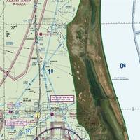
The National Oceanic and Atmospheric Administration (NOAA) has awarded Fugro two mapping projects on the US Gulf Coast to monitor and quantify shoreline change in this flood-prone region.The projects, located in Texas and Louisiana, are underway and were awarded under an existing indefinite delivery indefinite quality (IDIQ) contract to support the agency’s Coastal Mapping Program. Geo-data deliverables are scheduled for Q3 2023 and will be integrated into the national shoreline dataset…
Sperry Marine Debuts Self-tuning Autopilot
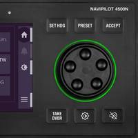
Sperry Marine has unveiled NAVIPILOT 4500N, a networked, self-tuning, fully adaptive heading control system. The first in a new series of autopilot systems, NAVIPILOT 4500N is designed to deliver improved course-keeping with reduced fuel consumption and a lower workload on the bridge, the company said.NAVIPILOT 4500N delivers the heading control performance that users expect from Sperry Marine, minimizing unwanted rudder motion and lowering drag, thereby saving fuel and contributing to greater efficiency.
NAVTOR Launches NavFleet, the Latest Name in Fleet Optimization
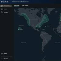
NAVTOR launched NavFleet, touted by the company as a "breakthrough application" developed over the past two years in collaboration with shipowners designed to open up a new horizon of possibilities: enabling real-time operational insight, performance optimization and enhanced business decision making for fleet management.NAVTOR has made its name through the development of a suite of e-Navigation products, delivered, updated and connected through a cyber secure ecosystem that unites shoreside and vessel teams.
LR to Acquire C-MAP Commercial from Navico

Lloyd's Register (LR) said it has reached a deal to acquire Navico Group’s C-MAP commercial marine business, a provider of commercial marine cartography and digital publications, shore-side and shipside voyage optimization, cloud-based fleet management and fleet analytics software. Financial terms were not disclosed. The acquisition, which includes C-MAP’s charts and publications, route planning and fleet management, weather services, professional services, and marine hydrographic services, will be integrated with into Lloyd's Register's i4 Insight performance platform.
ChartCo, Marine Press Merge into 'OneOcean'

ChartCo and Marine Press, both leaders in global digital navigation solutions, have announced their merger. The move will result in the creation of a new company called OneOcean which will offer the largest range of navigation and compliance solutions into the maritime sector.Martin Taylor, Chief Executive Officer of ChartCo, announced the merger, saying: “Following the success of three recent acquisitions, we have been looking to further expand our business. We identified Marine…
Navico and C-MAP Announce Merger
Navico – manufacturer of marine electronics and C-MAP – supplier of digital navigation products to the recreational and commercial marine market – announced that they have merged. Effective immediately, C-MAP will become another powerful brand in the Navico portfolio -- alongside Lowrance, Simrad and B&G.The merger will accelerate the companies’ shared ambition to create the world’s biggest digital marine ecosystem and deliver the best experiences for customers around the world.
New Members Join NOAA’s Hydrographic Services Advisory Panel
NOAA acting administrator retired Navy Rear Adm. Tim Gallaudet, Ph.D., has appointed three new members to the Hydrographic Services Review Panel, a federal advisory committee that gives NOAA independent advice for improving a range of services and products that support safe navigation and coastal resilience. Sean M. Duffy Sr., executive director, Big River Coalition, New Orleans, La. Retired USCG Capt. Julie Thomas, senior advisor, Southern California, Coastal Ocean Observing System, Scripps Institution of Oceanography, La Jolla, Calif.
Taking the Plunge into Digital
It’s a matter of when – not if. Digital is with us, and while many industries have embraced its potential, there is still some reticence in the shipping sector to take the plunge. Norwegian navigation expert Nautisk has rethought its entire product offering to embrace digital, so what have they learned? Nautisk’s head of marketing, John Dawson, explains. Nautisk has been a specialist chart agent for more than 100 years, and our core product base has been paper charts and printed publications for the shipping sector.
HENSOLDT Acquires Kelvin Hughes

Kelvin Hughes has been acquired by HENSOLDT (formerly Airbus Defense Electronics) as a result of an agreement by its owners ECI Partners to sell its investment in the company. “Following the buyout from Smiths Group, ECI has been a consistent and supportive partner as we have consolidated our position as a global leader in surveillance and security radar solutions,” said Kelvin Hughes CEO, Russell Gould. Completion of the transaction remains subject to regulatory clearances. HENSOLDT, an independent sensor house, is a provider of radar and IFF systems on airborne, naval and land platforms.
Transas, Japan Radio Company Announce Strategic Partnership
The strategic partnership will drive growth and accelerate innovation. Industry-leading solutions and services capabilities will deliver differentiated customer value. Transas, the innovative, digital solutions company, and Japan Radio Company (JRC), a leading global marine electronics company, today announced their new strategic partnership. The two industry-leading companies will work together in research and development, product distribution and project collaboration. The technical cooperation will be strongly reinforced including development of innovative solutions and will bring together the best hardware and best software to produce next-generation of e-Navigation products and solutions.
P&O Ferries Chooses GNS Solutions
Ferry company P&O Ferries will take advantage of GNS solutions to deliver purchasing cost efficiencies and simplify navigation management and compliance on board. P&O Ferries, the British ferry company that operates ferries from the U.K. to Ireland and Continental Europe, has selected maritime solutions provider GNS to provide navigation products and services for its fleet of 15 vessels. Under the terms of the agreement, GNS will supply digital and paper navigational products as well as its Voyager software to all P&O vessels for a fixed annual price.
Tideland Signal Acquires Julius Signal
Tideland Signal Corporation, now part of Xylem, has entered into a definitive agreement to acquire certain assets of Julius Signal, extending the company’s portfolio of marine and offshore aids to navigation offerings. Julius Signal’s product portfolio includes an array of marine aids to navigation products, complementary to Tideland Signal’s offering, and extends its capabilities with obstruction signals, offshore wind solutions and unique in-land waterway navigation aids including lock signaling and navigation signage. “Following on the recent acquisition of IMT, and now with the global backing of Xylem, we are in a position to serve our ocean and coastal customers with a broader array of Aids to Navigation solutions,” said Matt Scheuing, Tideland’s Managing Director.
FarSounder 3D Sonar for NACOS Platinum
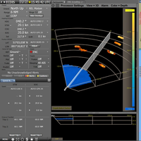
FarSounder, a developer of 3D forward looking sonar systems for navigation and obstacle avoidance, announced it has entered an integration partnership with Wärtsilä SAM Electronics. The partnership will see 3D sonar data from FarSounder’s navigation systems visualized and controlled directly from all NACOS MULTIPILOT workstations. The unique forward-looking capabilities of FarSounder's navigation products add a new dimension of situational awareness to the NACOS Platinum Series.
Transas e-Logbook Gets Panama Flag Approval
The Panama Marine Authority has confirmed the Transas Electronic Logbook as equivalent to the paper version for use on board the ships registered under the Panamanian Flag. Successful approval of the Transas e-Logbook by the largest shipping flag state is an important milestone in executing company's strategy to develop and deliver high-quality reliable e-Navigation products to its customers. The Transas Electronic Logbook (e-Logbook) is designed to replace traditional paper logbook and to record all data in full detail with a minimum input from a user. It is available as a software option for all users of the Transas Navi-Sailor ECDIS, the most popular ECDIS system among seafarers, and enables automated reporting.
Beier Radio Celebrates 70th Anniversary

Beier Radio, Inc. marks 70-years of providing engineering, sales and service for marine electronics around the globe. During its 70 years in business, Beier Radio has grown from being one of the first marine electronics distributors in the southern United States to a leader in integrated vessel control, navigation and communications systems as well as mariner training. “Beier Radio has always been committed to delivering products and services that meet the current demands of the marine industry and also anticipate the future needs of our customers in the challenging marine environment…
Beier Radio Marks 70 Years Serving Global Marine Industry

Beier Radio, Inc. marks its 70-year anniversary in 2015 providing engineering, sales and service for marine electronics around the globe. During its 70 years in business, Beier Radio has grown from being one of the first marine electronics distributors in the southern United States to a worldwide leader in integrated vessel control, navigation and communications systems as well as mariner training. “Beier Radio has always been committed to delivering products and services that…
NavStation to Launch at SMM
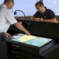
Touch screen technology has transformed everyday life and now, thanks to Norwegian e-navigation specialist NAVTOR, it is set to revolutionize operations onboard busy vessel bridges. Today sees the launch of the NAVTOR NavStation, the world’s first ‘Digital Chart Table’ and a breakthrough in bridge-based decision making tools. NavStation combines unique software with an optional 46inch ‘gigapad’ touch device, giving navigators an intuitive and user-friendly interface to plan optimal vessel routes.
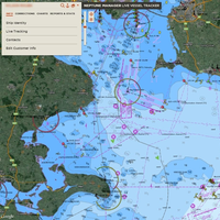
NOAA Offers a New Way to See Currents
A new NOAA National Ocean Service website will provide mariners near real-time coastal ocean surface current observations and tidal current predictions in coastal waters using high frequency (HF) radar, making marine navigation safer for mariners and commercial shippers. The web-based observations are now available for the Chesapeake and San Francisco Bays in areas vital for marine navigation, with additional locations to follow. The product was made possible by NOAA’s Center for Operational Oceanographic Products and Services (CO-OPS) using data from the NOAA-led U.S.
Integrated Bridge System Retrofit on Stena Ferries
Northrop Grumman Corporation's Sperry Marine business unit provided a fully networked suite of scalable navigation products from the VisionMaster FT™ series, to form the core of ship's integrated bridge on several Stena Line RoPax ferries. The Stena Superfast VII and Stena Superfast VIII vessels were upgraded with VisionMaster FT™ navigation radars, a voyage data recorder, and an electronic chart display and information system (ECDIS) that provides full control on both bridge wings. Meanwhile, the Stena Europe and Stena Adventurer were outfitted with the VisionMaster FT™ ECDIS, which meets the International Maritime Organization's (IMO) regulations for paperless navigation while providing a separate…
Northrop Grumman Upgrades Navigation Equipment on Stena Line Ferries

Northrop Grumman Corporation has completed an integrated bridge system retrofit for several RoPax ferries operated by Stena Line. Northrop Grumman's Sperry Marine business unit provided a fully networked suite of scalable navigation products from the VisionMaster FT series, used to form the core of a ship's integrated bridge. The Stena Superfast VII and Stena Superfast VIII vessels were upgraded with VisionMaster FT navigation radars, a voyage data recorder, and an electronic chart display and information system (ECDIS) that provides full control on both bridge wings.
NOAA Nautical Charts Now Permanently Free

After a three-month trial period, PDF versions of NOAA nautical charts will become a permanent product, free to the public. The free PDFs, which are digital images of traditional nautical charts, are especially valued by recreational boaters who use them to plan sailing routes and fishing trips. The free PDF charts are part of a suite of new and enhanced navigational products designed to make NOAA’s data more accessible to the general public. “Up to date charts help boaters avoid groundings and other dangers to navigation…
CEACT Allows Operators to REACT
How updated electronic navigation practices improve safety and efficiency – and optimize cargo movement – on US inland waterways. It was a cold winter night. Heavy gusts and snow did not allow safe navigation and forced the ships on the upper Mississippi to secure alongside the few remaining jetties. Safety is the key issue for all river transport companies but at the same time efficiency and timely delivery of valuable goods is of utmost importance. It was 1999 and an American navigation pioneer – Greg Dunkle – had realized the potential of electronic chart systems.
KVH Precision Sensors for Geodetics' Inertial Navigation Systems
KVH Industries entered into a strategic partnership with Geodetics Inc., a leader in the development of real-time, high-precision position and navigation solutions. The goal is to provide high performance positioning and navigation products for commercial applications requiring high levels of precision, from unmanned platforms to terrestrial navigation. Geodetics is integrating the KVH 1750 inertial measurement unit (IMU) into two solutions: Geo-INAV Advanced, a GPS-aided inertial navigation system; and Geo-ReINAV, a high-accuracy relative navigation, positioning, and orientation system. The KVH 1750 IMU provides highly accurate 6-degrees-of-freedom angular rate and acceleration data…


