Nautical Charts – NOAA Testing QR Code Effectiveness

OceanGrafix inform that NOAA QR codes are now available on 8 US nautical charts
OceanGrafix, the exclusive provider of NOAA print-on-demand (POD) nautical charts for U.S. waters, announce that QR codes are now available on eight NOAA charts for the Tampa Bay, Fla., area. The National Oceanic and Atmospheric Administration (NOAA) added the QR codes in an effort to test their effectiveness in providing valuable and timely information to mariners.
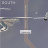
Quick Response Codes, or QR codes, are two-dimensional bar codes that can be scanned by a smart phone to direct users to digital content online. In this instance, boaters can scan the QR codes on select NOAA nautical charts to access real-time data sites for important information such as tides, currents, and marine weather.
Instead of searching several websites to gather marine information, the QR code can be scanned once to immediately access up-to-date data for the boater’s particular geographic area. Numbered icons on the chart match up with the web menu.
“While consumers have been somewhat slow to adapt to QR codes in other applications, this is the perfect scenario for how they should be used, and I hope mariners will take advantage of this unique feature,” says OceanGrafix President Ron Walz. “Having real-time navigational information at your fingertips will not only be convenient, but could also be a critical safety tool.”