

Surveyors Map Sunken Liberty Ship off Texas Coast
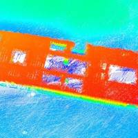
U.S.-based marine data acquisition services company TDI-Brooks said it recently mapped the Liberty Ship George Vancouver off Freeport, Texas while out on a seabed survey project with the R/V Brooks McCall. The multiple multi-phase geophysical and geotechnical site surveys program consisted of pipeline routing and subsea structures to facilitate route and project design for offshore developers.Equipment used to map the ship was a Teledyne Reson SeaBat T-20 multibeam sonar with integrated Applanix POSMV for Motion.
MetalCraft Building Multi-Beam Hydrographic Survey Craft
MetalCraft Marine Inc., of Kingston, Ontario, is nearing completion of its second Hydrographic Survey Craft for the Canadian Government's Department of Fisheries and Oceans (DFO), Canadian Hydrographic Service. The 30 x 10.3 ft. vessel will carry three transducers, the largest being a state of the art 332 mm Multi-beam Transducer by Kongsberg-Simrad, Model EM-3000. The total Multi-beam system is worth approximately three times the value of the vessel, which was sold for $129,000. The Canadian Hydrographic Service, Central and Arctic Regions is responsible for updating and validating Canadian navigational charts for all inland and Arctic waters, including the Great Lakes and the St. Lawrence Seaway.


