

Great Lakes Bags $173.7 Million in New Dredging Contracts
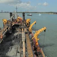
Great Lakes Dredge & Dock Corporation on Thursday announced the receipt of five dredging contracts totaling $173.7 million. The projects are in Texas, New Jersey, Florida and Louisiana.The Sabine-Neches Waterway Channel Improvement Project-Phase 1 (Capital, Texas, $62.8 million) includes dredging for channel deepening along the Sabine-Neches Waterway from Sabine Bank Channel to Sabine Pass Channel. The construction of the Sabine-Neches Waterway will generate widespread economic benefits for Southeast Texas…
US' MARAD Announces Grants to Boost Supply Chain Efficiency

The U.S. Department of Transportation’s Maritime Administration (MARAD) awarded nearly $12 million in grants to eight marine highway projects across the nation under the United States Marine Highway Program (USMHP). The funding will improve the movement of goods along our navigable waterways and expand existing waterborne freight services in Alaska, Illinois, Indiana, Louisiana, Texas, Washington, and Wisconsin, which will strengthen supply chains and ultimately cut costs for consumers.“Our country has always relied on American waterways to get vital goods where they need to go,” said U.S.
Robust Dredging on America’s Inland Waterways
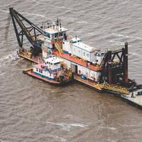
Inland Dredging Company helps keep commerce flowing on America’s inland waterway system.Dyersburg, Tenn. based Inland Dredging Company completed dredging projects spanning eight states and across four U.S. Army Corps of Engineers Districts. Beginning in July and finishing in December (2019), Inland Dredging crews dredged ports and harbors along the Mighty Mississippi River, Ouachita River, Red River, Black Warrior River, Atchafalaya River, Tennessee–Tombigbee Waterway, and the Gulf Intercoastal Waterway from Apalachicola to Morgan City.Richard Jackson…
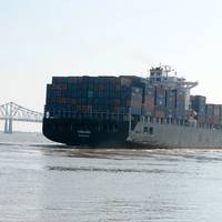
Vessels Queue Grows as Salvage Continues on the Intracoastal Waterway
Nearly 200 towing vessels and 600 barges are queued on the Intracoastal Waterway while salvors work to clear a halved and partially sunken rock barge near Berwick, La., the U.S. Coast Guard said.A section of waterway has been closed since Sunday night, when a towing vessel pushing six rock-filled hopper barges ran aground at mile marker 99.The push boat Miss Odessa was reportedly transiting southbound on the Atchafalaya River when it turned west onto the Gulf Intracoastal Waterway and hit bottom. One of the barges, ACL 01700, split in half and sunk when the vessel attempted to break free.
Towing Vessel Grounds Near Berwick, La.
A section of the Gulf Intracoastal Waterway has been closed after a towing vessel ran aground at mile marker 99, near Berwick, La., the U.S. Coast Guard said.Watchstanders at Vessel Traffic Service Berwick Bay received a report at approximately 10 p.m., Sunday, that the towing vessel Miss Odessa, carrying six hopper barges filled with rock, ran aground.The Miss Odessa was reportedly transiting south-bound on the Atchafalaya River when it turned west onto the Gulf Intracoastal Waterway and hit bottom.
New Orleans Braces for TS Barry
Some residents and visitors prepared to flee New Orleans on Thursday as Tropical Storm Barry closed in and city officials warned of severe flooding if it makes landfall by early Saturday as the first Atlantic hurricane of the 2019 season.The storm had maximum sustained winds of 40 miles per hour (64 kph) as of 10 a.m. CDT (1500 GMT) on Thursday, the National Weather Service said.Forecasters issued a storm-surge warning for a stretch of Louisiana coastline south of already-sodden New Orleans stretching from the mouth of the Atchafalaya River to Shell Beach.
Rerouting a River
The Old River Control Structure and its future implications for the Mighty MississippiPrior to about 1500, the bodies of water now called the Mississippi River and the Red River (also known as the Red River of the South) were roughly parallel along their southern reaches, each emptying separately into the Gulf of Mexico. About 1500, the Mississippi, which has a long history of meandering, developed a large bend to the west in the vicinity of what is now Point Breeze, Louisiana. That bend, sometimes referred to as Turnbull’s Bend, connected with the Red River and had the effect of making the Red River basically a tributary of the Mississippi, with only a small portion of its waterflow continuing south. That southern waterflow is now called the Atchafalaya River.
Louisiana Dredging Outlook
When maritime stakeholders think about dredging, they typically first conjure up visions of harbor deepening projects to accommodate those giant, post-Panamax boxships. Conversely, inland players hope for maintenance dredging in the heartland to keep the nation’s 31,000 cargo barges afloat as they head for the coast. But, there is much more to it than that. In Louisiana, dredging, of course, keeps Louisiana's waterways open for navigation, provides material for coastal restoration and helps industrial plants with drainage. The biggest projects are sponsored by the U.S.
Video: New Channel Established on Atchafalaya River
The U.S. Coast Guard (USCG) helped establish Crewboat Cut as a new federal channel in the Atchafalaya River near Morgan City, Wednesday. The new waterway is intended to be safer for mariners, will shorten travel time and save millions of dollars in annual dredging costs. Coast Guardsmen with Coast Guard Aids to Navigation Team Morgan City and Coast Guard Cutter Axe constructed new channel markers in the waterway. A video discussing the new channel is available here: http://www.dvidshub.net/video/367318/coast-guard-helps-establish-new-waterway#.VEEsF2f1bgZ.
The Gulf Intracoastal Waterway – A Silent Giant No More

The recent enactment of the Waterways Resources Reform and Development Act of 2014 (WRRDA) has brought a sense of optimism to inland waterways mariners, operators and industries across the nation. Our inland waterways are poised for success, and key to that success is the anticipated support provided in that bill. Of course, follow on appropriations and carefully planned implementation is critical to assure continued success of our waterways system. One segment of that system, the Gulf Intracoastal Waterway (GIWW) is growing in importance and value to the nation.
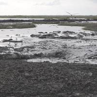
Large Dead Zone Found in Gulf of Mexico
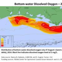
Mapped size confirms NOAA forecast for an average-sized hypoxia zone this year. NOAA- and EPA-supported scientists have mapped the Gulf of Mexico dead zone, an area with low oxygen water, measuring 5,052 square miles this summer--approximately the size of the state of Connecticut. The measurements were taken during the 30th annual hypoxia survey cruise from July 27 to August 2. This area falls within the predicted range of 4,633 to 5,708 square miles forecast by a suite of NOAA-sponsored models…
Swiftships Unveils USV with the University of Louisiana-Lafayette
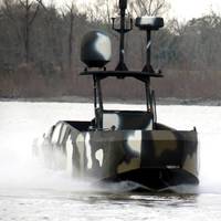
Last month, Swiftships Shipbuilders, LLC, in Morgan City, La., showcased the Anaconda-2 – an unmanned, 35-ft. craft in development – during a demonstration on the Atchafalaya River next to its HQ. The company partnered with the University of Louisiana at Lafayette more than a year ago to produce technology for a vessel that can navigate without a pilot aboard. Swiftships and ULL are designing a boat that uses Global Positioning System/sensory data, and has the potential to support naval, enforcement and zone-protection operations, mainly on inland waters.
Maritime Training Expands to Meet Louisiana Gulf Demand
Employers are hiring in coastal Louisiana, especially as offshore drilling picks up in the Gulf of Mexico. Companies are concerned about finding enough skilled workers in a locally tight labor market. For mariners, a variety of training programs at different levels and costs are offered in south Louisiana. For those businesses without the significant wherewithal and training resources of a Kirby Corporation, for example, there are other viable options for training. Fletcher Technical Community College: The college’s Louisiana Marine and Petroleum Institute or LaMPI was founded in the late 1970s to provide local maritime training. The institute provides Coast Guard-approved courses to about 2,200 mariners a year now. Fletcher and LaMPI are located in Houma on the Louisiana Gulf.
Atchafalaya River Temporary Closure
The US Coast Guard has established a temporary safety zone closing to navigation the Atchafalaya River from Mile Marker 117 (Morgan City Railroad Bridge) to Mile Marker 0 (Simmesport, Louisiana). This action is necessary to protect against destruction, loss, or injury due to hazards associated with rising flood water. The safety zone will be in effect through July 31. 76 Fed. Reg. 35104 (June 16, 2011). Source: Bryant’s Maritime News
Conrad Industries Withstands Rising Waters
Conrad Industries, Inc. (OTC Pink Sheets: CNRD.PK) provided an update today on the impact of the rising waters of the Mississippi River and the Atchafalaya River on its operations. Johnny Conrad, President and CEO stated, “On May 11, 2011 we announced the potential adverse impact on our business of the rising water levels along the Mississippi and Atchafalaya Rivers. We are happy to report that the only adverse impact to date has been the temporary suspension of operations at our Morgan City shipyard which is located on the Atchafalaya River outside the protection of the levee system. "We relocated all of our production and support personnel and many of our projects to our other shipyards and continued operations at a minimally reduced level.
Conrad Announces Q1 2011 Results

Conrad Industries, Inc. (OTC Pink Sheets: CNRD.PK) announced today its first quarter 2011 results and backlog, and discussed challenges presented by the rising waters of the Mississippi River and the Atchafalaya River. For the quarter ended March 31, 2011, Conrad achieved net income of $3.7 million and earnings per diluted share of $0.58 compared to net income of $1.7 million and earnings per diluted share of $0.27 during the first quarter of 2010. The Company’s financial reports are available at www.otcmarkets.com.
New USACE Contract
Weeks Marine, Inc., Covington, La., was awarded on Aug. 14, 2009 a $14,877,000 firm-fixed-price contract for Atchafalaya River and Bayous Chene, Boeuf, and black, Atchafalaya Bar Channel, Maintenance Dredging C/L Sta. 475+00, Non-Continuous (09-2), St. Mary Parish, La. Work is to be performed in St. Mary Parish, La., with an estimated completion date of Dec. 12, 2009. Bids were solicited using the World Wide Web with two bids received. U.S. Army Corps of Engineers, New Orleans District, New Orleans, La. is the contracting activity (W912P8-09-C-0103).
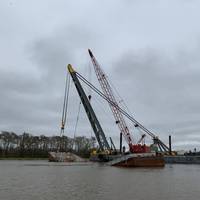
Bisso Marine Salvages Buried Crane

Bisso Marine recently mobilized a salvage team, the salvage support barge C/B BIG EAGLE and the 700 ton capacity D/B Cappy Bisso to salvage a crawler crane which had fallen into the Atchafalaya River in Berwick, La. The crane, which weighed approximately 100 tons, was knocked into the river upon contact with the HWY 90 Bridge in 2005. At the salvage location the water was 30 ft. deep, but in the two years since the collision, the crane had settled to approximately 25 feet below the river bottom.
Morgan City Harbor and Terminal Completes Upgrades
Strategically located along the Louisiana Gulf Coast at the junction of the Gulf Intracoastal Waterway and the Atchafalaya river, the Morgan City Harbor and Terminal District has just completed construction of a medium draft vessel port. This major Louisiana inter-modal transportation facility features an 800-ft. concrete wharf; a 20,000-sq. ft. fire protected transit shed, two-paved cargo marshalling yards covering 117,000 sq. ft., two-rail sidings connecting directly to the cross country Burlington-Northern/Santa Fe main railroad line, a large crane and forklifts to handle containerized cargo and ready highway access to the US Highway 90 (Interstate 49) freeway.
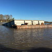
Two Towboats Sink
The Coast Guard is responded yesterday after two towboats, with four people sank, while tied alongside the dock on the Atchafalaya River in Krotz Springs, La. At just after 4 a.m. the Coast Guard received a call that the MISS MARJORIE, a 50-foot towing vessel, and the AMY SUE, a 62-foot towing vessel, were tied together and moored to the dock at the Krotz Springs Valero Refinery, when the deckhand noticed the MISS MARJORIE taking on water. The deckhand woke up the captain and crew just before the MISS MARJORIE sank, subsequently sinking the AMY SUE as well. Three crewmembers safely jumped to the pier while the forth, the captain, swam safely to shore.
New Vessel Traffic Control Tower Completed
A new $1.1m Vessel Traffic Control Tower was recently completed at Mile Marker 99 of the Gulf Intracoastal Waterway adjacent to Jesse Fontenot Memorial Boat Landing in Berwick, La. The purpose of the tower is to provide additional camera vantage points looking westward along the Intracoastal Waterway, southward along the Lower Atchafalaya River and northward toward Berwick Bay. In addition, the tower will be equipped with a TERMA radar and Automatic Identification System (AIS) transceiver to update and improve the overall Ports and Waterways Safety System in order to provide increased situational awareness for the U. S. Coast Guard vessel traffic controllers at Vessel Traffic Service (VTS) Berwick Bay. Captain Terry Gilbreath, the Commanding Officer of U.
Mississippi River Commission Schedules Meeting For Friday
Dock, at mile 53 on the Houma Navigation Canal. communities along the Mississippi River. August 11 in St. Paul, Minn. directly address their views to members of the Commission. through Old River Lock to reach the Atchafalaya River. Waterway.
U.S. ENC Availability Starts to Gain Speed
It is no secret that acceptance and incorporation of electronic charting systems has been more widespread in Europe than in the U.S., as European governments and commercial organizations collectively have worked more diligently together and built and maintained a lead in this area. The gap, however, is closing, as the era of the electronic chart is quickly arriving in the U.S. In a recent Advance Notice of Proposed Rulemaking (ANPRM), the U.S. Coast Guard announced that it is considering the feasibility of allowing commercial vessels to use electronic charting and navigation systems as their primary means of navigation in U.S. waters. It would have to meet ECDIS standards as supplied by the IMO.


