

Two-way Route in the Great Barrier Reef and Torres Strait
The IMO-adopted ship routeing measure to enhance the safety and efficiency of navigation and protect the region’s sensitive marine environment will come into effect at 0000 UTC on 1st December 2014. The two-way route aims to reduce the risk of collisions and groundings by separating opposing streams (e.g. north and south-bound) of traffic and encourage ships to follow well-defined lanes. The route will also help ensure ships keep clear of the numerous shoals, reefs and islands that lie close outside, particularly in the northern portion of the GBR and Torres Strait. The IMO-adopted two-way route extends from the western end of Torres Strait, through the Prince of Wales Channel, the GBR Inner Route and terminates at the southern boundary of the GBR Marine Park (see chartlet attached).
Australian Navy Surveys Antarctica
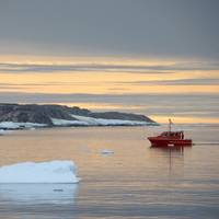
The Royal Australian Navy’s Deployable Geospatial Survey Team returned from a six-week Antarctic expedition to collect essential data for navigational charts and scientific research. The team sailed from Hobart in RSV Aurora Australis on December 11, 2013 to conduct a hydrographic survey in the vicinity of Casey Station, a permanent base in Antarctica managed by the Australian Antarctic Division (AAD). “We sailed the Wyatt Earp from Aurora Australis seven times in conditions of extreme cold to collect high quality data…
Australian Reef Protected by New Safety Initiative
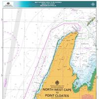
To protect the World Heritage-listed Ningaloo Coast in Western Australia’s north-west region, the Australian Maritime Safety Authority (AMSA) to establish an area ships should avoid. A new AMSA Marine Notice will recommend ships keep at least two nautical miles from the edge of Ningaloo Reef at its narrowest part, and between eight and 12 nautical miles from the reef along the remainder of the Ningaloo Coast section to reduce the risk of shipping accidents and help protect the World Heritage listed region from ship-sourced pollution.
Shipping Fairways NW Australia Discussed at AMSA Meeting
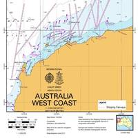
The third meeting of the Navigation Safety Advisory Group (NSAG) recently met to consider safety of navigation concerns in Australian waters. (NSAG is the peak consultative body for matters relating to the Australian Maritime Safety Authority's (AMSA) responsibilities for the safety of navigation in Australian waters). The meeting attracted 24 navigation practitioners and representatives from the Australian Hydrographic Service, port and state marine authorities, industry peak bodies, shipping companies and marine pilots.


