

AWO Advocate Robust USCG Arctic Presence
Crowley Maritime Corp. V-P, testifies on behalf of American Waterways Operators (AWO) to Senate Subcommittee. Bruce Harland, Vice President-Commercial Services of Crowley Maritime Corporation, has testified on behalf of Crowley and the American Waterways Operators (AWO) before the U.S. Senate Homeland Security Appropriations Subcommittee at a field hearing held in Kodiak, Alaska. The hearing, which was held at the request of Sen. Lisa Murkowski (AK-R) and led by Subcommittee chairwoman Sen. Mary Landrieu (D-LA), focused on the need for a robust U.S. Coast Guard presence in Alaska as the nation pursues expanding navigation opportunities in the Arctic region.
Polarcus Alima travels the Northern Sea Route
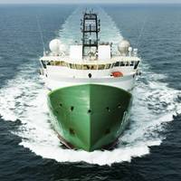
One of the X-BOW vessels designed by ULSTEIN, the seismic vessel ‘Polarcus Alima’, recently transited to Asia-Pacific via the Northern Sea Route (NSR). This is the first known passage of a 3D seismic vessel along the Northern Sea Route. Her passage commenced on September 15 from Hammerfest in Norway after completion of seismic operations in the Barents Sea. After only nine days and 3,000 nautical miles the vessel reached Cape Dezhnev in the Bering Straits. She is presently continuing her onward passage to New Zealand to commence operations there.
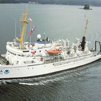
NOAA’s Fairweather Maps Bering Straits
Responding to a request from the U.S. Navy, U.S. Coast Guard, Alaska Maritime Pilots and the commercial shipping industry, NOAA sent one of its surveying vessels, NOAA Ship Fairweather, to detect navigational dangers in critical Arctic waters that have not been charted for more than 50 years. Fairweather, whose homeport is Ketchikan, Alaska, will spend July and August examining seafloor features, measuring ocean depths and supplying data for updating NOAA’s nautical charts spanning 350 square nautical miles in the Bering Straits around Cape Prince of Wales.
NOAA Fairweather Updates Arctic Charts
As Arctic ice recedes, countries are looking forward to faster, safer and more efficient sea routes across the top of the world. Responding to a request from the U.S. Navy, U.S. Coast Guard, Alaska Maritime Pilots and the commercial shipping industry, NOAA sent one of its premier surveying vessels, NOAA Ship Fairweather, to detect navigational dangers in critical Arctic waters that have not been charted for more than 50 years. Fairweather, whose homeport is Ketchikan, Alaska, will spend July and August examining seafloor features, measuring ocean depths and supplying data for updating NOAA’s nautical charts spanning 350 square nautical miles in the Bering Straits around Cape Prince of Wales.
USN Awards 391 Contractors
The U.S. Navy is awarding indefinite-delivery/indefinite-quantity multiple award contracts to 391 contractors that will provide for their competition for service requirements solicited by Naval Sea Systems Command, Naval Air Systems Command, Space and Naval Warfare Systems Command, Naval Supply Systems Command, Military Sealift Command, Naval Facilities Engineering Command, Strategic Systems Programs, and the United States Marine Corps. The 22 functional service areas within the scope of the contracts include 1. Research and Development Support. 2. Engineering System Engineering and Process Engineering Support. 3. Modeling, Simulation, Stimulation, and Analysis Support. 4. Prototyping, Pre-Production, Model-Making, and Fabrication Support.


