

MBARI Works at Unlocking Ocean Biology
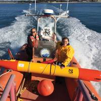
Greater understanding of what goes on in the ocean is starting to become a reality – thanks to growing use of unmanned surface and underwater vehicles and developments in biological sensing. Elaine Maslin takes a look at what a team at MBARI has been doing.Gathering biological data from the oceans remains a significant challenge for oceanographers. Now, an increasing range of unmanned vehicles that are able to work together is becoming available, as is an ability to collect biological data using them.It sounds straight forward…
Esri GPS Base Station Joins National Network
Esri recently installed a GPS base station to assist its GIS developers and to support surveyors, engineers, scientists, and those in public works and public safety in the community surrounding the Esri campus in Redlands, California. The base station, named GISA, has been accepted by the National Geodetic Survey (NGS) and incorporated into the national Continuously Operating Reference Station (CORS) network. "GPS, originally designed as a US Department of Defense system, has become part of everyday life, with the technology in all types of devices from smartphones to shipping containers," said Brent Jones, Esri surveying and engineering industry manager.


