

New Bermuda Islands Paper and Digital Charts
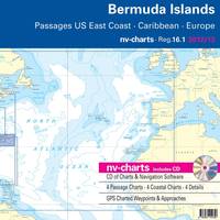
Cruising sailors visiting Bermuda now have a new, up-to-date, remarkably detailed set of charts for the islands in both paper and digital format, exclusively from nv-charts, a global supplier of precision charting products for mariners. The new Bermuda chart set, Region 16.1, is the latest and most complete charting package for the navigationally-hazardous Bermuda islands to appear in many years, and is more complete and detailed than the limited charting resources for Bermuda that have been available for so long.
Underwater Metal Detectors Assist in Artifact Recovery

Underwater metal detector is successfully used for the African Slave Wrecks Project. In October 1619 the naval warship Warwick sailed into the King’s Castle Harbour in Bermuda with an important cargo from England; the colony’s new governor, Captain Nathaniel Butler. After taking on provisions the Warwick was to travel onto the struggling colony at Jamestown, Virginia, but it never made the voyage. Before the ship could sail, Bermuda was hit by a fierce hurricane. Battered by strong winds the Warwick broke free from her anchors…


