

Electronic Navigational Charts: An Update and Some Issues
In November 2019, the Office of Coast Survey (OCS), part of the National Oceanic and Atmospheric Administration (NOAA), announced the start of a five-year program to “sunset” all raster and paper nautical charts.NOAA has produced electronic navigational charts (ENCs) since 1993. In the 2019 notice, NOAA writes that “ENC sales increased 425% since 2008, while sales of paper charts are now half of 2008 levels.”For NOAA and mariners, a focus on electronic charts and publications promises many advantages. With a singular focus, NOAA can use its resources more efficiently.
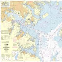
NOAA Continues Transition to Electronic Navigational Charts
NOAA is continuing with the sunset plan for paper and raster nautical charts in August and September. A set of 15 charts covering the eastern half of the North Slope of Alaska will be moved into last edition status on August 5, 2021 and will be canceled on February 2, 2022. Another set of 14 charts covering the western half of the North Slope will be moved into last edition status on September 2, 2021 and be cancelled on March 2, 2022.This set of charts has been fully supplanted by new electronic charts as part of NOAA’s Office of Coast Survey Raster Sunset Plan…
NOAA Begins Transition Exclusively to Electronic Navigation Charts
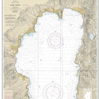
NOAA will begin to implement its sunset plan for paper nautical charts this month, starting with the current paper chart 18665 of Lake Tahoe. After August, NOAA’s electronic navigational chart will be the only NOAA nautical chart of the area.This is the first traditional paper chart to be fully supplanted by an electronic chart as part of NOAA’s Office of Coast Survey Raster Sunset Plan, which includes a new process to notify mariners of the transition of individual paper charts to electronic charts.
Introducing 7Cs Analyzer
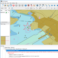
For more than 20 years, numerous digital chart producers (Hydrographic Offices, Waterway Authorities, and other organizations) have used SevenCs validation tools for quality control and quality assessment of digital charts such as ENCs, IENCs, and AMLs against the relevant standards.At SevenCs, we have been working hard to improve our validation solutions and now the new 7Cs Analyzer Version 4.0 is available. The new Analyzer is based on SevenCs latest S-100 Kernel technology and provides the most comprehensive validation tool on the market.
ARGUS: Enviable Technology, Unlimited Potential
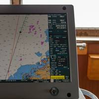
System is designed to universally interface with a vessel’s existing navigation equipment and autonomously deliver water depths seen by the vessel to a central server. Almost four years and 100 million soundings later, the concept is a reality. Almost two years after we first reported (December 2011 edition of MarineNews) on an innovative, depth sounding recorder device that made wide swaths of data available to perhaps anyone who wants it, the concept envisioned by ARGUS has developed into a viable tool that could change the way that government agencies schedule surveys and dredging. Today, about 40 boats have voluntarily placed on board their vessels the ARGUS (Autonomous Remote Global Underwater Surveillance) system transmitters.
NV Charts Release Free Mobile Navigation App
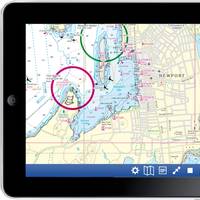
Motor boaters, sailors, and cruisers who want to ride the cutting‐edge crest of navigation with mobile devices can now take advantage of NV charts App, a new, simple‐to‐use free app now available from NV charts, a global leader in highly accurate, detailed maritime chart products. The new NV charts App is free and makes it a simple matter to download NV charts’ superior chart regions to iPads, iPhones and all iOS platforms as well as Android operating devices. For years, NV charts has offered paper charts, as well as digital versions for download onto a laptop or notebook PC for navigation.
Underwater Survey System Patented
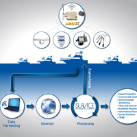
The U.S. Patent and Trademark Office has issued a patent for the ARGUS™ (Autonomous Remote Global Underwater Surveillance) system. The purpose of ARGUS™, which has been in operation and field testing since 2010, is to automate the acquisition and processing of depth, environmental, and meteorological data from coastal and inland waterways and provide the data to Government, commercial, academic, and other interested organizations. The autonomous onboard system (without the need…
Train Crews to Avoid the ECDIS Adoption Cliff
Training can often assume intimidating dimensions and become a worrying bottleneck in any change process or industry transformation. The ECDIS mandate is a prime example. The significance of training was underlined by José Sergio Gabrielli, head of Petrobras, when speaking about development of Brazil’s Santos basin field at the 2011 NorShipping Conference. “We will have to train at least 200,000 people […]. It is a long term human resources challenge,”he told Conference delegates.
NOAA to Deliver More Charts, Faster

Revolutionary Change in NOAA Nautical Chart Production Means More Products, Faster, for Maritime Use. NOAA's development of a new navigational chart processing system, designed to meet the changing needs of the maritime community, moves into initial limited production on September 21. The new system, which slims down the current map production process while it beefs up performance, represents a technological leap forward in creating the navigational charts used to speed ships and products safety through the nation's maritime transportation system.
Kelvin Hughes and Zener Marine Expand Operations in Dubai

Kelvin Hughes and Zener Marine are proud to announce the signing of a new distribution agreement which will include a full range of paper and digital charts and publications. • Paper and digital hydrographic charts and publications from Japan to the Baltic and Eastern USA along Panama with a concentration on Middle East coverage. • Technical Publications from the UKHO, IMO, ITU, Witherbys, Seamanship and more. • The Weems & Plath range of quality nautical instruments available in Dubai for the first time. Commenting on the new agreement, Mr D.S.
NOAA Adds Vector Charts in Agreement with Maptech
The National Oceanic and Atmospheric Administration (NOAA) and Maptech, Inc. have successfully negotiated an expansion of their existing Cooperative Research and Development Agreement to include a new and advanced generation of vector electronic navigational charts (ENC). Under the expanded agreement, NOAA will produce highly accurate and up-to-date ENC "data" for the major U.S. ports. This data, and already available raster data, will be the foundation for a new chart product for the marine industry. Maptech will enhance and repackage the NOAA data into ENC chart "products" designed to meet the specific needs for commercial and recreational marine customers. The ENC products will be distributed in the S-57 format established by the International Hydrographic Organization.


