

Dinh-Zarr to Serve as NTSB Acting Chairman

Christopher A. Hart’s term as Chairman of the National Transportation Safety Board concluded on schedule Wednesday and Vice Chairman Bella Dinh-Zarr will serve as the agency’s acting chairman. Hart will remain at the NTSB, applying his transportation safety expertise in the capacity of a board member. The NTSB has five board members, each nominated by the President and confirmed by the Senate to serve five-year terms. By statute, a board member is designated by the President as Chairman and another as Vice Chairman for two-year terms. The Chairmanship requires separate Senate confirmation.
NTSB Reports on Safety Risks in Shared Waterways
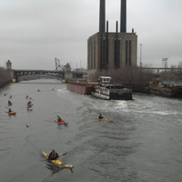
The National Transportation Safety Board issued a report Thursday identifying the risks associated with the shared use of America’s Marine Transportation System by recreational and commercial vessels. The growth of both commercial and recreational vessel traffic during the last several decades is a significant risk factor. The number of canoers, kayakers and standup paddleboarders increased by nearly 22 percent between 2008 and 2014. The diversity of waterway users and their differences in experience, navigational knowledge, and boat-handling skills exacerbate the safety risk.
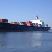
El Faro’s Voyage Data Recorder Recovered
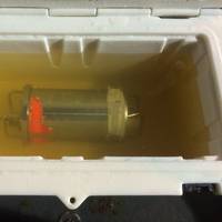
The voyage data recorder (VDR) from El Faro, a U.S. flagged cargo ship that sank during Hurricane Joaquin in October 2015, has been recovered from the ocean floor late Monday evening, the U.S. National Transportation Board (NTSB) said. The recovery of the capsule caps a 10-month-long effort to retrieve the recorder, which was designed to record navigational data and communications between crewmembers on the ship’s bridge. Investigators hope the recorder will reveal information about the final hours of El Faro’s voyage and the circumstances leading up to the sinking.
El Faro’s Voyage Data Recorder Located
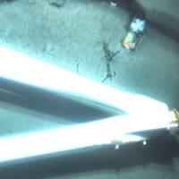
The voyage data recorder (VDR) belonging to sunken cargo ship El Faro was found early Tuesday morning in 15,000 feet of water, about 41 miles northeast of Acklins and Crooked Islands, Bahamas, the National Transportation Safety Board (NTSB) announced. A specialist team comprised of investigators and scientists from the NTSB, the U.S. Coast Guard, Woods Hole Oceanographic Institution and Tote Services, the owner and operator of El Faro, located the VDR using remotely operated undersea search equipment. Video footage showing El Faro's VDR is available here. At about 1 a.m.
NTSB to Search for El Faro’s Voyage Data Recorder
The National Transportation Safety Board (NTSB) said it will initiate a second search expedition to the wreckage of sunken El Faro in an effort to gather further evidence in its investigation of the loss of the containership, which sank in the Atlantic during Hurricane Joaquin on October 1, 2015. A key objective of the mission, which is expected to begin in April and last about two weeks, is to locate the voyage data recorder (VDR) and to provide investigators with a more extensive and detailed survey of the shipwreck, NTSB said, adding the exact launch date will be announced later.
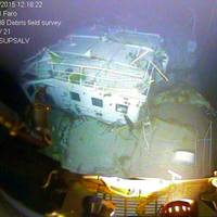
NTSB: Sunken Cargo Ship El Faro "Black Box" Still Missing
The video documentation of the cargo ship El Faro and the associated debris field has been completed but the vessel’s voyage data recorder was not located, according to the National Transportation Safety Board. “Over the years we’ve completed many investigations without the aid of recorders and other investigative tools,” said NTSB Chairman Christopher A. Hart. The 790-ft. ship went missing on Oct. 1 during Hurricane Joaquin and was located on Oct. 31 in about 15,000 feet of water in the vicinity of its last known position near Crooked Island, Bahamas.
Poor Communication behind Houston Ship Collision
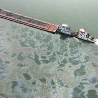
The National Transportation Safety Board (NTSB) determined that the Miss Susan, a shallow draft towing vessel with two barges, and the Summer Wind, a deep draft bulk carrier, collided on March 22, 2014, because the towing vessel crossed the Houston Ship Channel, impeding the passage of the bulk carrier that was transiting inbound, which could only transit within the channel. The collision resulted in the release of 168,000 gallons of fuel into the Houston Ship Channel from the…


