

Thoma-Sea Awarded Contract to Build Two NOAA Research Ships
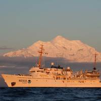
Houma, La. shipbuilder Thoma-Sea Marine Constructors has been awarded a contract to design and build two new research vessels for NOAA, for expected delivery in 2027 and 2028.The $624.6 million deal was awarded following a request for proposals that was open June–October 2022 and includes purchase options for up to two more vessels.The new ships will be less than 90 meters long, engineered to focus primarily on ocean mapping and nautical charting as part of NOAA’s mission to deliver tools and information to help mariners safely navigate the nation’s ports and harbors.
Winners of Walter B. Jones Memorial Awards Named
Eleven individuals and organizations have been named as winners of the 2014 Walter B. Jones Memorial Awards for Excellence in Coastal Ocean Resource Management, an award given by NOAA’sOffice for Coastal Management for exemplary leadership and a commitment to balancing the human use of coastal and ocean resources with the needs of the environment. These national awards, given every two years, honor individuals and organizations that have dedicated countless hours to conserve, protect, and improve the U.S. coasts. They recognize the application of innovative approaches, tools, or technology to advance the field. “This year’s award winners represent a wide range of uniquely driven people and activities in the pursuit of wise coastal resource management,” said Jeffrey L.
NOAA Seeks Hydrographic Panel Members
NOAA is seeking qualified candidates to apply for up to five voting member vacancies to serve on its Hydrographic Services Review Panel (HSRP) as of January 1, 2014. The HSRP is a federal advisory committee that advises the NOAA Administrator on current and emerging oceanographic and marine science technologies relating to operations, research and development; and dissemination of data pertaining to: a) hydrographic surveying; b) shoreline surveying; c) nautical charting; d) water level measurements; e) current measurements; f) geodetic measurements; g) geospatial measurements; h) geomagnetic measurements; and i) other oceanographic/marine related sciences.
Oregon Offers Wave Energy Development Opportunites
State of Oregon has amended its Territorial Sea Plan to allow for siting of marine renewable energy development projects in state waters. The amendment identifies four "Renewable Energy Suitability Study Areas" along the Oregon coast where initial development of wave energy will be encouraged and pose the least conflict with existing ocean uses and natural resources. The four areas are located off the coasts of Lakeside, Reedsport, Nestucca, and Camp Rilea, and total about 22 square miles or two percent of Oregon’s territorial sea.


