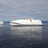
S. Korea Plans Autonomous Ship Research Facility

UIPA, the South Korean Information and Communication Technology Promotion Agency, awarded Kongsberg Digital the contract to supply a fully-featured bridge simulator for a new autonomous ship research facility in Ulsan, South Korea. The Korean government has committed to invest $110 million in the project over the next three years, with a goal of starting operations in 2023. The simulation contract is being delivered through maritime ICT convergence specialists eMARINE Global.The simulator will be used primarily for research and development of navigational equipment and display systems…
On Patrol with Cutting Edge Technology
Combat, patrol and first responder craft of all types are increasingly in need of state-of-the-art equipment to get the job done. That’s where FLIR and Raymarine come in.Raymarine products are known around the world for their rugged reliability and tactical advantage. From best-in-class sensors to integrated navigation displays, Raymarine systems enhance multi-agency interoperability for military, law enforcement and first responders. As a trusted supplier to myriad coastal and response vessels, Raymarine offers a comprehensive suite of professional tools. That mission is about to get bigger still.In April of 2017, FLIR was awarded a $50 million contract from the U.S. Coast Guard for integrated navigation electronics under the U.S.
EU-backed Autonomous Shipping Project Moves Forward
Hull to Hull (H2H), an EU-funded research project established to develop technical solutions for safer navigation in close proximity of other stationary or moving vessels and objects, is in its Concept Definition phase and will move on to the Technology Adaption and Integrations Work Package (WP03) this summer.H2H was established in November 2017 to develop solutions using the European Global Navigation Satellite System (EGNSS), EGNOS and Galileo, that can enhance safety in busy waters and during close maneuvering…
Software Solutions: Monitor & Track

As the maritime industry embraces the digital revolution, companies like GateHouse are poised to prosper. GateHouse in developing software solutions to support optimization, flexibility and mission critical operations for vehicle and vessel tracking, monitoring and satellite communications. We caught up with Michael Bondo Andersen, CEO and founder of GateHouse, for insights on his strategy moving the company forward. Looking at your maritime unit, Big Data is having a transformational impact on global maritime. Please detail your offering.
New Controls, Display Systems for CXO300 Outboard

British company Cox Powertrain said it will announce two exclusive new partnerships at this year’s Seawork International and showcase the engine control and display systems that have been chosen for the company’s high powered diesel outboard engine, the CXO300, ahead of its launch next year. Italian controls specialist Xenta Systems has been chosen to supply the engine controls system, which incorporates the joystick, throttle for the CXO300. Murphy by Enovation Controls will supply its new PowerView1200 display screen offering full-featured engine diagnostics on a powerful display screen.
SevenCs Launches New ECDIS Kernel
The new version of the SevenCs ECDIS Kernel SDK (Software Development Kit) 5.20 has been designed to meet all future requirements of the latest international standards to reduce implementation irregularities and improve the overall usability of chart display systems (IEC 61174 Standard edition 4.0; IHO S-52 Presentation Library edition 4.0; IHO S-64 Test Standard edition 3.0). Eric Rottman, Kernel SDK product manager, commented, “A major focus of the release version 5.20 has been laid on detection and indication of danger and caution objects.
Comark to Exhibit at Intelligent Ships Symposium
Comark, a designer and manufacturer of high performance computer and display solutions, will exhibit at the 2015 Intelligent Ships Symposium May 20-22, at the University of Pennsylvania Annenberg Center in Philadelphia. The Intelligent Ships Symposium is a biennial event which provides a forum for the military, government, academia and industry to come together to discuss technology initiatives that provide solutions to current and future needs of the U.S Navy. Located in booth #22, Comark will exhibit the latest computer and display systems of the MissionVue product line. Developed for the CDS TI-16 program, the MV242D 24 Display offers the latest in multi and glove touch technology with a Hi-Bright LCD LED Display.
Simrad HALO Pulse Compression Radar launched
Navico Commercial Marine Division today launched the Simrad HALO Pulse Compression Radar, the world’s most affordable solid-state, open-array radar system with pulse compression technology for non-SOLAS applications aboard commercial vessels. Combining the advantages of Simrad FMCW Broadband Radar and traditional pulse radar systems, HALO radar detects targets as close as 20 feet (6 metres) – well within pulse radar’s short-range “blind spot” – while delivering exceptional long-range performance up to 72 nautical miles. HALO radar provides unmatched target resolution, with Beam Sharpening for enhanced target separation control. In Dual Range mode…
Nautical Chart Updated for Charleston Harbor
The new nautical chart 11525 extends eastward, to cover an additional pilot boarding area for vessels headed to the Charleston Harbor. Ships entering the Port of Charleston will have a new and improved nautical chart that covers a larger area to ensure safer navigational approaches into the harbor. Available on the 4th of July, new chart 11525 (Charleston Harbor Entrance and Approach) replaces the old chart 11523 (Charleston Harbor Entrance). It expands chart coverage further east, covering an additional 345 square nautical miles that wasn’t on the old chart.
Electronic Cartography Market worth $20 Billion by 2020
According to the report "Electronic Cartography Market by Application (Marine - Commercial and Defense, Aviation - Marine - Commercial and Defense), Components (Systems, Charts), Marine Electronic Navigation Systems (ECDIS, ECS), Aviation Electronic Navigation Systems (Very Large Aircrafts, Wide Body Aircrafts, Narrow Body Aircrafts), Marine Electronic Charts Licensing Mode (PAYS, Direct), Geography (APAC, Europe, North America, South America, Middle East and Africa) Forecast and Analysis, 2014-2020", published by MarketsandMarkets, the electronic cartography market is expected to reach $20.3 billion, growing with a CAGR of 1.46% from 2014 to 2020. The last few years have witnessed a well paced revolution in the electronic cartographic market.
Northrop Grumman Awarded US$88-Million Navy Contract
According to the US Department of Defense, Navy, Northrop Grumman Systems Corp., Charlottesville, Va., is being awarded an $88,153,800 contract to acquire integrated bridge systems and steering/ship control systems, related hardware and associated services. DoD explains that the systems are comprised of chart servers, network interface boxes, flat panel displays, radar systems, navigation software, ship control software, global positioning systems, weather sensors, depth sensors, speed sensors, digital compass systems, ship control display systems and sonar systems. These items represent a modernization upgrade from existing systems currently in use.
NOAA Nautical Charts Now Permanently Free

After a three-month trial period, PDF versions of NOAA nautical charts will become a permanent product, free to the public. The free PDFs, which are digital images of traditional nautical charts, are especially valued by recreational boaters who use them to plan sailing routes and fishing trips. The free PDF charts are part of a suite of new and enhanced navigational products designed to make NOAA’s data more accessible to the general public. “Up to date charts help boaters avoid groundings and other dangers to navigation…
NOAA Updates New York Harbor Charts Post-Sandy
Ships, barges, ferries, and recreational boats in the busy New York Harbor will be able to navigate more safely thanks to an updated version of the harbor’s nautical chart recently issued by NOAA that includes data gathered in the navigational response to the damage caused by Sandy in October 2012. The latest edition of Chart 12334 – New York Harbor includes new depth measurements and shoreline depictions. “This new chart edition is the first product of a multi-year post-Sandy charting plan,” said Rear Admiral Gerd Glang, director of NOAA’s Office of Coast Survey.
McMurdo Widens AIS Range with Smartfind M15 Receiver
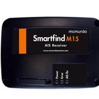
McMurdo, a business of the Orolia Group, announced that the Smartfind M15 Automatic Identification System (AIS) Receiver is now available. Designed for recreational vessels using a computer with AIS-capable navigation software, it receives AIS messages, so can see other AIS equipped vessels within VHF range and can assist with collision avoidance. The Smartfind M15 AIS Receiver will decode all AIS messages that are transmitted by AIS Class A, Class B transponders, AIS SARTs, AIS MOBs and Aids To Navigation, the manufacturer claims.
Cambridge Pixel Enhances RadarView
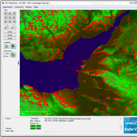
RadarView allows electronic navigation charts (ENC), tiled maps, world vector shoreline, and raster images, to be displayed with the primary radar video. Cambridge Pixel , a developer of sensor processing and display solutions, has enhanced its RadarView Windows-based radar visualisation software tool to allow complex map and charts, for example, electronic navigation charts (ENC), tiled maps, world vector shoreline, and raster images, to be displayed with the primary radar video.
Ulstein Bridge Vision Debuts
With the internal mandate to create better, safer and simpler solutions for ships’ crews, Ulstein introduces its patent-pending Ulstein Bridge Vision – a concept that promises major improvements for the operational centers of vessels. - a new breed of user-defined ergonomic work stations. Arne Ove Rødstøl, Product Manager Bridge in Ulstein Power & Control, explained that Ulstein engineers sought the expertise of industrial, graphic and interaction designers from The Oslo School of Architecture and Design (AHO).
New Anschuetz Autopilot Series NP 5000
The German-based navigation company Raytheon Anschütz announced the upcoming release of their new NautoPilot 5000 adaptive autopilot series, the successor of their NP 2000 autopilot series. The NP 5000 is based on the same Anschütz steering algorithms, but is enhanced to include highly advanced functions for economic and precise navigation such as an integrated steering performance display and a new course control operation mode. The new autopilot’s most obvious feature certainly is its large graphical display which offers six different day and night modes within an intuitive to operate touch screen. The screen is designed in line with the colour palettes which are in use for the display systems of Radar, Chart-Radar and ECDIS.
Lockheed, Navy Display Systems Contracts
Lockheed Martin has received a six-year contract from the U.S. Navy to provide performance-based logistics support for the AN/UYQ-70 (Q-70) Advanced Display System. The contract provides Q-70 logistics and supply support at over $13m a year for the first two years, with options for additional support over the next four years, bringing the total potential contract value to $72m. This contract follows a recently awarded $525.6m modification to the NAVSEA AN/UYQ-70(V) Advanced Display Systems production contract. The contract will be managed out of Lockheed Martin's business in Eagan, Minn., and products will be delivered from the company's Virginia Beach, Va., location. If option years are exercised, the contract will continue until 2014. Q-70 systems are widely used in U.S.
Navy Evaluates Display Technology
The Program Executive Officer for Integrated Warfare Systems (PEO IWS), Rear Adm. Tom Bush, hosted an industry day on August 7 to brief interested manufacturers and invite industry feedback on a recently released draft Indefinite Delivery Indefinite Quantity (IDIQ) solicitation to manufacture Navy Display Systems as well as develop and produce the Navy's next generation of displays, the Future Common Display System. The Navy's Future Common Display System will be the follow-on to the AN/UYQ-70, Advanced Display System. More than 3,200 AN/UYQ-70, Advanced Display Systems have been produced and integrated into ship, submarine, and aircraft combat systems.
Reality Checked
Shipowners are about to find themselves under a barrage of propaganda about electronic charts and the display systems that run them. These systems have been around for some years, and are used heavily in the offshore, dredging, fishing and leisure fields. But merchant shipping, with a few exceptions, has shied away from using electronic charting, preferring to wait for a common international standard and type-approved equipment. The common standard is now in place, and the first approved ECDIS systems are entering the market. By this summer, there will be a choice of systems, some offering glossy boxes with shiny buttons and some offering facilities owners never dreamt they needed. But what is the reality?
AIS: When & Where? Here & Now!
The events of September 11, 2001 will continue to have lingering effects on the world indefinitely. The most visible remnant in the maritime world is the drastically heightened sense of safety and security, as officials in countries around the globe seek to secure their borders from the threat of attack — either direct or covert — via ship. Many of the issues currently on the legislative fast track were already in the works pre-September 11. False crew documentation, enhanced vessel tracking and beefed-up harbor controls were much-discussed topic in previous years. As is the case more often than not, though, a disaster of some proportion is inevitably the impetus in moving from discussion to action.
Product: MX Marine Unleashes New Family of Electronics
At the Europort 2003 exhibition in Amsterdam last month, MX Marine debuted its new family of marine GPS/DGPS products, a family of products designed to provide a flexible and expandable platform for the next generation of integrated navigation and marine information systems. "These three new GPS products represent the leading edge of the new wave in marine navigation technology," said David Ritblatt, president of MX Marine. "The MX500, MX510 and MX520 will take the concept of integrated navigation systems to the next level, serving as the platform for a fully integrated marine information center." The new MX500, MX510 and MX520 GPS control/display systems are being introduced by MX Marine to work with the MX521 smart antenna or MX525 black box receiver…
MX Marine Introduces New GPS Products
MX Marine has unveiled a new family of marine GPS/DGPS products, which are designed to provide a flexible and expandable platform for the next generation of integrated navigation and marine information systems. The new MX500, MX510 and MX520 GPS control/display systems are being introduced by MX Marine to work with the MX521 smart antenna or MX525 black box receiver, providing a highly accurate integrated navigation solution that meets the latest international standards for GPS/DGPS, including Receiver Autonomous Integrity Monitoring (RAIM). The new-generation MX500, MX510 and MX520 are the first marine GPS systems to incorporate a common platform with the powerful Intel X-Scale 200 MHz processor with 16 MB Flash and 64 MB SDRAM memory, upgradeable to 400 MHz and 128 MB RAM.