

NOAA’s Coast Survey Plans for New Arctic Nautical Charts
Less sea ice and more ship traffic means new charts needed for safety. NOAA’s Office of Coast Survey has issued an updated Arctic Nautical Charting Plan, as a major effort to improve inadequate chart coverage for Arctic areas experiencing increasing vessel traffic due to ice diminishment. The update came after consultations with maritime interests and the public, as well as with other federal, state, and local agencies. “As multi-year sea ice continues to disappear, vessel traffic in the Arctic is on the rise,” said Rear Admiral Gerd Glang, NOAA Coast Survey director.
Arctic Nautical Charts: NOAA Plans Updates

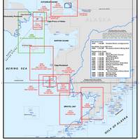
Less sea ice and more ship traffic means new charts needed for safety. NOAA’s Office of Coast Survey has issued an updated Arctic Nautical Charting Plan , as a major effort to improve inadequate chart coverage for Arctic areas experiencing increasing vessel traffic due to ice diminishment. NOAA plans to create 14 new charts to complement the existing chart coverage. For example, seven of the charts will complete chart coverage from the Alaska Peninsula to Cape Lisburne at the edge of the North Slope…
NOAA: New AK Chart Makes Arctic Safer

NOAA: New Alaska navigational chart makes increased Arctic shipping safer; Kotzebue Harbor chart replaces measurements last taken in 19th century. NOAA formally presented today to Alaska officials a new nautical chart for Kotzebue Sound in the Alaskan Arctic, a sparsely charted region that is seeing increased vessel traffic because of the significant loss of summer sea ice. The new chart depicts the full range of depth measurements and object detection acquired during a full ocean bottom survey last summer by the NOAA hydrographic survey ship Fairweather.
NOAA Begins Production With Esri

GIS Creates Integrated Data Workflow for More Efficient Chart Production. The National Oceanic and Atmospheric Administration (NOAA) has implemented a new nautical charting system based on Esri GIS technology to produce more navigational products than ever before without increasing its budget or personnel needs. The new system, NCS II, is based on Esri Nautical Solution, and it allows NOAA to centralize the management of hydrographic data for US coastal waters. Since accepting Esri Nautical Solution as part of its production system in 2009…


