

exactEarth to Provide AIS Services for MDA's Dark Vessel Detection Program
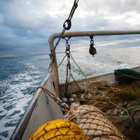
exactEarth Ltd. has signed an agreement with MDA to provide advanced Satellite-AIS data services as part of MDA's recently announced Dark Vessel Detection (DVD) program for the Government of Canada. The DVD program is intended to detect and identify vessels that have switched off their AIS transponders and are engaged in illegal, unreported and unregulated (IUU) fishing.IUU fishing is a global problem that results in significant economic loss—estimated at $23 billion per year…
exactEarth Tallies $5.2 Mln AIS Data Deal
Satellite-AIS data services provider exactEarth Ltd. said it has expanded an alliance agreement with one of its existing channel partners.The amended agreement extends the current deal between the companies by 3.5 years to December 2023. exactEarth estimates that this amended agreement will generate additional incremental revenues of approximately $7 million CAD ($5.2 million), or $2 million CAD ($1.5 million) per year on an annualized basis.Under the terms of the new agreement…
Airbus Enhances OceanFinder capabilities
Aerospace solutions provider Airbus Defense and Space has upgraded its digital maritime service to detect and track vessels around the globe.First launched in 2018, OceanFinder leverages Airbus’ advanced constellation of optical and radar satellites, combined with real-time global Automatic Identification System (AIS) data, and the latest in automated analytics, to support a broad range of critical applications across defense and security, shipping, oil and gas, and insurance markets.OceanFinder’s latest updates introduce a number of innovative features – extending the service’s capabilities in several key areas.From today, users will benefit from enhanced imagery and AIS data correlation to identify the precise location of a non-responding vessel in near real-time.
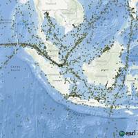
MarineTraffic Partners With exactEarth
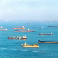
MarineTraffic is partnering with exactEarth to deliver additional real-time information to its users.The additional satellite data compliments the MarineTraffic coastal receiver network: the world's largest and most extensive system consisting of 3,500 points of presence allowing for real-time vessel tracking data of most of the global shipping fleet. The addition of exactEarth data to the existing satellite dataset on MarineTraffic will particularly enhance the visibility of vessels in both the Gulf of Mexico and the South China Sea.
Space X Launches Fourth Set of Iridium NEXT Satellites
Iridium Communications announced that, SpaceX successfully launched the fourth set of 10 Iridium NEXT satellites into orbit from Vandenberg Air Force Base in California. The launch marks the midway point of the Iridium NEXT launch program, and was the first Iridium launch to use a SpaceX flight-proven rocket. The first stage booster for Iridium-4 was previously used for Iridium-2, making Iridium the first company to reuse the same rocket booster. Each launch strategically delivers new satellites to specific orbital planes, so that the complete Iridium NEXT constellation will be operational as soon as possible after all launches are complete.
Iridium NEXT Successful Third Launch

Iridium Communications has announced the successful third launch and deployment of 10 Iridium NEXT satellites. The satellites were delivered into low-Earth orbit approximately one hour after a SpaceX Falcon 9 rocket lifted off from Vandenberg Air Force Base in California at 5:37 a.m. PDT. With two successful launches having already been completed this year, this third batch of 10 satellites brings the total number of Iridium NEXT satellites in orbit to 30, nearly half the amount required for a full Iridium NEXT operational constellation.
exactEarth, Alltek Expand Small Vessel Tracking Service
Satellite AIS data services provider exactEarth Ltd. announced that its exactTrax small vessel monitoring technology is now incorporated into Alltek Marine Electronic Corp’s (AMEC) AIS Tracking Beacon (TB560). The AMEC TB560 is a simplified Class B AIS device that offers an efficient and cost-effective vessel monitoring solution within AIS VHF transmission range. Now outfitted with exactTrax technology from exactEarth, which extends small vessel tracking beyond traditional coastal surveillance, the AMEC TB560 can reliably be detected from space. exactTrax allows for the secure transmission and reliable detection of signals from the millions of artisanal and small-scale commercial fishing boats and small commercial work boats currently operating around the world.
exactEarth Expands Small Vessel Tracking Offering
Satellite AIS data services provider exactEarth Ltd. has made its small vessel tracking solution, exactTrax, available for integration with all AIS transceiver manufacturers. A number of different exactTrax-enabled transceivers are already available, which enables customers to choose the most appropriate hardware for their small vessel tracking needs. exactTrax is a solution for providing users with a complete picture of small vessel activity in their maritime domain. exactTrax continually monitors the millions of small vessels navigating the world’s oceans and waterways, and supports SOLAS (Safety of Life at Sea), fisheries management…
New Real-time Maritime Tracking Service
exactEarth Ltd , provider of Satellite AIS data services announces the launch of exactView RT powered by Harris (exactView RT) – the world’s first global, persistent real-time Satellite AIS service. This capability is expected to enable a wide variety of new service capabilities for the global maritime community and to contribute strongly over the next 20 years to the improvement of maritime safety, commerce, navigation, environmental management and security. exactView RT consists of a system of more than 60 maritime satellite payloads…
Ghana's Vessel Tracking Deal for exactEarth
exactEarth Ltd. has been selected by the Fisheries Commission (West Africa Regional Fisheries Programme), an agency of the Ministry of Fisheries and Aquaculture Development (MOFAD) of the Government of Ghana, for the provision of Satellite AIS data services as well as a small vessel tracking solution. The contract value is in a range of $1.0-$2.0 million for a 12 month period and will enable Ghana to acquire the technology necessary to monitor its expansive coastlines and deter illegal fishing in its national waters. Along with a comprehensive Satellite AIS data feed, exactEarth will provide MOFAD with 450 Class B AIS transceivers to be installed on inshore fishing vessels which will be tracked via satellite utilising exactEarth’s exactTrax small vessel tracking technology.
Small Vessel Tracking Tested in South Africa
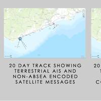
exactEarth Europe Limited, a UK subsidiary of exactEarth Ltd, a provider of Satellite AIS data services, recently concluded the main part of its ‘South Africa Safety Initiative for Small Vessels’ (OASIS) project – a small vessel tracking trial with the South African Maritime Safety Authority (SAMSA), part-funded by the UK Space Agency (UKSA) under its ‘International Partnership Space Program’ (IPSP). A key aspect of SAMSA's mandate is to ensure safety of life at sea, including small vessels in the fisheries, leisure marine and workboat sectors.
Partnership Offers Real-time Maritime Tracking
Satellite Automatic Identification System (AIS) data services provider exactEarth Ltd.and space, geospatial and remote sensing solutions company Harris Corporation have formed an alliance to provide a new level of AIS data service that will deliver real-time global coverage for maritime vessel tracking. The new service will leverage the persistent global coverage and real-time connectivity of the Iridium NEXT constellation through the implementation of 58 hosted payloads covering the Maritime VHF frequency band. Compatibility testing of the hosted payload with the Iridium satellites has been completed and the first launch is scheduled for early 2016 with the completed constellation expected in 2017.
AIS Satellite Launch Date Set
The highest detection performance Automatic Identification System (AIS) satellite ever built, will be launched by a Soyuz launch vehicle from the Baikonur Cosmodrome in Kazakhstan on on 22nd July 2012. AIS is currently deployed on more than 80,000 vessels globally, however AIS base station receivers are mostly based on land and can only track ships moving up to 50 nautical miles off the coast. exactEarth is pioneering space-based AIS services that increases the range, enabling the monitoring of vessels throughout the World’s oceans. exactView-1 (previously known as ADS-1b) was built under contract for exactEarth and will become the fifth deployed satellite in exactEarth’s advanced vessel monitoring satellite constellation.
exactEarth at GeoMaritime 2012
exactEarth is exhibiting at and sponsoring the first annual GeoMaritime event in London, UK running June 13-14. The company is looking forward to participating in this unique forum where industry, defence, government and commercial organisations will gather to explore the benefits of maritime geospatial information and discuss current issues facing the maritime surveillance sector. The VP of Global Sales and Marketing for exactEarth, John Allan, will be presenting in association…
Singapore and London Celebrate AXSDry4.0’s Launch
On Thursday 24th May, AXSMarine unveiled AXSDry4.0, a software to replace their current widely used AXSDry software, by hosting Launch parties in London and Singapore. On May 24th 2012, AXSMarine officially launched AXSDry4.0. The invitation only event gathered over 300 guests from the dry bulk industry. Companies who attended include Benline, BRS, Cargill, GFI, ICAP, Kline bulk, Navico, Noble, Oldendorff, Raffles, SSY and many other important players from the shipping industry. Held in two new trendy places, The Exchange (Singapore) and The Oyster Shed (London), the events gave guests the opportunity for a first look at the revamped chartering system.
exactEarth Receives New Orders
exactEarth Ltd., a satellite AIS data services provider, announced that it has recently booked multiple orders for exactAIStm, its global vessel tracking and monitoring system. The orders, which have been placed by government agencies in several countries including South Africa and Japan, are in excess of $2 million over the next 12 months. exactEarth also announced that the commissioning process related to its recent satellite launch is proceeding well and this advanced AIS payload will be placed into service this month as planned. In a series of tests the satellite payload, newly named exactView2, has demonstrated very good vessel detection rates in even the highest-density shipping areas of the world.
exactEarth Assists in Pacific Rim Disaster Relief
In response to the recent earthquake and tsunami that brought devastation to Japan and the Pacific Rim, exactEarth is offering its data service free of charge for the next two weeks to any competent maritime authority wishing to have access to their vessels anywhere in the Pacific Rim. With thousands of vessels presently in the Pacific Rim region, exactEarth is offering this service in efforts to assist in locating vessels for search and rescue incidents. This is a continuation of one of exactEarth's core missions - to help save lives in support of humanitarian efforts. The next several days are critical for rescue efforts and the entire exactEarth team is standing by to assist. Please contact [email protected] or call 519-622-4445 for further information on this offer.


