

What's in a Foot? December 31, 2022 Marks End of U.S. Survey Foot
NOAA and the National Institute of Standards and Technology (or NIST) are starting the new year off on the “right” foot.On New Year’s Eve, the two federal agency partners will officially retire the use of one of two measuring feet, to reduce surveying errors that can cost money.Discontinuing the use of the U.S. survey foot and embracing of its replacement — the international foot — are also part of NOAA’s modernization of the National Spatial Reference System.“Officially retiring one of these measurements will reduce accidental confusion in engineering…
NOAA Hires Fugro to Monitor Shoreline Changes in Texas, Louisiana
The National Oceanic and Atmospheric Administration (NOAA) has awarded Fugro two mapping projects on the US Gulf Coast to monitor and quantify shoreline change in this flood-prone region.The projects, located in Texas and Louisiana, are underway and were awarded under an existing indefinite delivery indefinite quality (IDIQ) contract to support the agency’s Coastal Mapping Program. Geo-data deliverables are scheduled for Q3 2023 and will be integrated into the national shoreline dataset…
New Lineup for NOAA Hydrographic Services Panel
NOAA administrator Kathryn Sullivan, Ph.D., has appointed six members to the Hydrographic Services Review Panel, a federal advisory committee that gives NOAA independent advice for improving a range of services and products that support navigation and coastal resilience. Capt. “Providing coastal communities, boaters, and the commercial maritime industry with timely, reliable, accurate, and authoritative information is essential as we strive to keep commerce flowing through our nation’s ports,” Sullivan said. Rear Admiral Ken Barbor (ret.), U.S. Lawson W. Capt. Gary A. Scott R.
Navigational Charts App Debuts at Ocean Business
An independent consultancy and software development company will launch a new web and PC based navigational charting app at Ocean Business 2015. Norcom Technology Limited said its eChart software combines up to date information from different sources including wreck, cable, tide and geographical data for navigational charts, making it suited for use by companies carrying out desktop studies prior to installation of offshore structures, cables, pipelines and vessel monitoring.
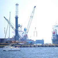
Geo Shipyard Delivers Catamaran Survey Vessel
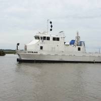
Geo Shipyard, Inc. has built and delivered a new Survey Catamaran Vessel, Blake, for David Evans and Associates Inc.’s Marine Services Division in Gulfport, Mississippi. The newbuild, delivered in October, features wave-piercing bows, Tier 3 Cat diesels, twin 55-kW generators, a full suite of survey instrumentation, an A frame for towing astern, a DTI survey winch and a stainless steel hydraulically operated survey strut with a moon pool and hydraulically operated door through the wing deck to lower the strut for side scanning. There’s also a bow crane for side scanning in shallow water.
DEA’s New 82-foot Survey Vessel Commissioned
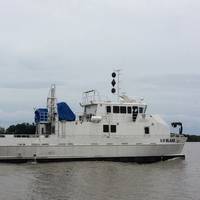
David Evans and Associates, Inc.’s Marine Services Division commissioned its new 82-foot hydrographic survey and scientific vessel Blake in a ceremony held in the vessel’s homeport of Gulfport, Mississippi. At the ceremony, U.S. Senator Thad Cochran of Mississippi broke a Champagne bottle across the Blake’s bow. In addition to remarks by the Senator, Rear Admiral Gerd Glang, the director of the National Oceanic and Atmospheric Administration’s Office of Coast Survey and the U.S. National Hydrographer, and Mayor of Gulfport William Gardner Hewes spoke to attendees.
19th Century Shipwreck Found off Golden Gate Bridge
NOAA announced it has found the underwater wreck of the passenger steamer City of Chester, which sank in 1888 in a collision in dense fog near where the Golden Gate Bridge stands today. The announcement was made during a press event at Gulf of Farallones National Marine Sanctuary’s San Francisco headquarters at Crissy Field. NOAA’s predecessor agency first located ship in 1890, two years after it sank. The story of City of Chester will be shared with the public in a future waterfront exhibit NOAA will place at the sanctuary office at Crissy Field. The office is the former U.S.
Coast Survey to Resove Magenta Line Issues
The Office of Coast Survey has announced that future editions of nautical charts of the Intracoastal Waterway will be updated to include an improved "magenta line" that has historically aided navigation down the East Coast and around the Gulf Coast. Additionally, Coast Survey will change the magenta line's function, from the perceived "recommended route" established more than a hundred years ago, to an advisory directional guide that helps prevent boaters from going astray in the maze of channels that comprise the route.
NOAA Updates New York Harbor Charts Post-Sandy
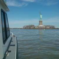
Ships, barges, ferries, and recreational boats in the busy New York Harbor will be able to navigate more safely thanks to an updated version of the harbor’s nautical chart recently issued by NOAA that includes data gathered in the navigational response to the damage caused by Sandy in October 2012. The latest edition of Chart 12334 – New York Harbor includes new depth measurements and shoreline depictions. “This new chart edition is the first product of a multi-year post-Sandy charting plan,” said Rear Admiral Gerd Glang, director of NOAA’s Office of Coast Survey.
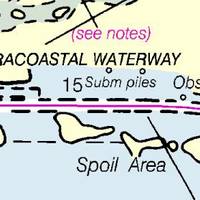
NOAA Updates Cobscook Bay Area Chart
Northern Maine vessels will be able to navigate more safely around the dangerous Cobscook Bay thanks to an updated version of the area's nautical chart issued by NOAA. The latest chart includes a new detailed illustration-called a "chart inset"-of the waters around Falls Island, providing safer passage for mariners who transit those waters. While NOAA cartographers had updated Chart 13394 (Grand Manan Channel) over the past several years, using depth measurements and obstruction locations acquired during a major hydrographic survey in 2010, a new inset was needed specifically for Falls Island. "Larger, more detailed scale coverage helps mitigate the dangers to navigation in these areas," explained Cmdr. Shep Smith, chief of NOAA Office of Coast Survey's Marine Chart Division.
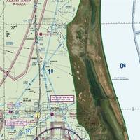
New Navigational Product Trio from NOAA
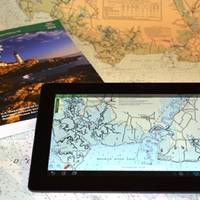
NOAA highlight new US Chart 1, new chart of California waters with IMO TSS shown, and a beta mobile chart app for boaters. New U.S. For the 65 years since the U.S. Coast and Geodetic Survey issued the first edition of U.S. Chart No.1 in 1948, mariners have had a standard guide for understanding the symbols, abbreviations and terms used on paper nautical charts. In a major step forward, a new edition of that guide also describes the symbols specified by the International Hydrographic…
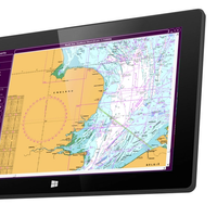
US Chart No. 1 Goes Electronic
U.S. Coast and Geodetic Survey Chart No.1 has described the symbols used on paper nautical charts for 65 years. Mariners have had a standard guide for understanding the symbols, abbreviations and terms used on paper nautical charts since 1948. In a major step forward, a new edition of that guide also describes the symbols specified by the International Hydrographic Organization for the display of electronic navigational charts (ENC) on Electronic Chart Display and Information Systems (ECDIS). Several maritime nations produce their own versions of Chart 1. The U.S. Chart No.
NOAA & US Power Squadrons Sign Agreement
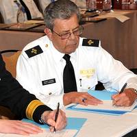
NOAA’s Office of Coast Survey & US Power Squadrons sign a Memorandum of Agreement to improve cooperative charting program. Rear Adm. Gerd Glang, director of NOAA’s Office of Coast Survey, recently sat down with John Alter, chief commander of the U.S. Power Squadrons (USPS) to sign up to a collaboration that began fifty years ago. The USPS is a nonprofit organization dedicated to safe boating through instruction in seamanship, navigation, and related subjects. With nearly 40,000 members in more than 400 squadrons across the U.S.
NOAA and U.S. Power Squadrons Renew Program
This week, NOAA and the U.S. Power Squadrons, a non-profit organization dedicated to safe boating, will renew a 50-year commitment to a cooperative charting program that helps to update the nation's thousands of navigational charts. Under the voluntary program, formalized by a Memorandum of Agreement, members of the U.S. Power Squadrons scan water and land areas, looking for changing conditions that may not be reflected on NOAA nautical charts. Power Squadrons members submit their reports online, and NOAA cartographers review and incorporate changes to their navigation products. "The partnership between Coast Survey and the Power Squadrons is a long and successful one, speaking to our shared vision of safety on U.S.
Esri GPS Base Station Joins National Network
Esri recently installed a GPS base station to assist its GIS developers and to support surveyors, engineers, scientists, and those in public works and public safety in the community surrounding the Esri campus in Redlands, California. The base station, named GISA, has been accepted by the National Geodetic Survey (NGS) and incorporated into the national Continuously Operating Reference Station (CORS) network. "GPS, originally designed as a US Department of Defense system, has become part of everyday life, with the technology in all types of devices from smartphones to shipping containers," said Brent Jones, Esri surveying and engineering industry manager.
NOAA’s Coastal Mapping Program Offers Huge Benefits: Report
For every dollar American taxpayers spend on NOAA’s National Geodetic Survey (NGS) Coastal Mapping Program, they receive more than $35 in benefits, according to a recent independent socio-economic scoping study. The program provides critical baseline data for accurately mapping America’s official shoreline—important for national security, maritime shipping and navigation, and provides geographical reference data needed to manage, develop, conserve and protect coastal resources.
NOAA Announces New Members of The Hydrographic Services Review Panel
NOAA Administrator Jane Lubchenco recently appointed nine new members to the Hydrographic Services Review Panel, a federal advisory committee that gives NOAA independent advice for improving ocean and coastal navigation products, information, data and services. “Optimizing the benefits of navigation services and products is a priority for the agency,” said Margaret Spring, chief of staff for NOAA and the agency’s representative to the Committee on the Marine Transportation System (CMTS).
New Members of NOAA’s Hydrographic Services Review Panel
NOAA Administrator Jane Lubchenco recently appointed nine new members to the Hydrographic Services Review Panel, a federal advisory committee that gives NOAA independent advice for improving ocean and coastal navigation products, information, data and services. “Optimizing the benefits of navigation services and products is a priority for the agency,” said Margaret Spring, chief of staff for NOAA and the agency’s representative to the Committee on the Marine Transportation System (CMTS). “We look forward to hearing perspectives and receiving advice from our new committee members, who represent a wide variety of maritime and coastal zone stakeholder interests. Dr. Lawson W. Stephen Carmel, Maersk Line, Ltd. Jeffrey Carothers, Fugro Consultants, Inc. Dr. Dr. David A. Scott R.
NOAA Ship Decommissioned
U.S. decommissioned today in a ceremony at its home port in Norfolk, Va. waterways. manages the NOAA fleet of ships and aircraft. efficiently. charts. survey platform in the world. maritime commerce. terabytes - one terabyte equaling 1,000 gigabytes. mosaics as well as imagery of historical wrecks like the USS Monitor. oceanography, fisheries research and homeland security surveys. security and nautical charting and returned in November. marked an end to its 39 years of service. and all waters in between. the nation. finding the wreckage of John F. Kennedy's aircraft in 1999. 990 off the coast of Rhode Island. Cmdr. two years. Air 990 recovery efforts. tragedies involving aircraft lost at sea. who served in the U.S. Coast and Geodetic Survey. and the U.S. Naval Academy.
NOAA to Ensure GPS Accuracy
NOAA will lead an international effort to pinpoint the locations of more than 40 global positioning satellites in Earth orbit, which is vital to ensuring the accuracy of GPS data that millions worldwide rely upon every day for safe navigation and commerce. NOAA personnel will compile and analyze satellite orbit data from 10 analysis centers worldwide to ensure the accuracy of GPS information. For the next four years NOAA’s National Geodetic Survey will serve as the Analysis Center Coordinator for the International Global Navigation Satellite Systems Service, a voluntary federation of more than 200 organizations that provide continuous global satellite-tracking data.
NOAA Launches New Marine Science Portal
View of the USS Monitor wreck, which sank on Dec. 31, 1862, and now teams with marine life. NOAA and Immersion Presents launched oceanslive.org, a marine science portal that offers live video and special content to educate people of all ages about the ocean, including national marine sanctuaries. Immersion Presents is an after-school science education program founded by ocean explorer Robert Ballard. "NOAA is excited to offer this dynamic Internet-based resource, which will allow students, educators and the public to share in the thrill of discovery while learning more about the natural and cultural treasures of our national marine sanctuaries and the underwater world," said NOAA National Marine Sanctuary program director Daniel J. Basta.
HSRP Meeting
The Hydrographic Services Review Panel (HSRP) will be meeting November 19-20. The NOAA Hydrographic Services Review Panel (HSRP) is a Federal Advisory Committee that advises the NOAA Administrator on topics relating to operations, research and development, and dissemination of data pertaining to: hydrographic surveying; nautical charting; water level measurements; current measurements; geodetic measurements; and geospatial measurements. The HSRP will hold its next meeting in Tampa, Florida to discuss NOAA’s Navigation Services programs. The HSRP will hear from maritime interests and non-navigation users about connections to NOAA’s Navigation Services and Climate during two Stakeholder Panels. The agenda also includes a discussion of the Integration of PORTS® Data Into the U.S.
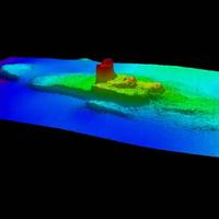
NOAA Team Assesses Debris Impacts in Gulf Region
view of side scan sonar image of sunken ship in Pascagoula, Miss. NOAA’s Office of Response and Restoration and Office of Coast Survey, working with the U.S. Coast Guard and other federal and state agencies, are assisting with Gulf of Mexico recovery efforts by performing hydrographic surveys and risk assessments of underwater debris left in the wake of Hurricane Katrina. The mapping aspect of the project will aid in the risk assessment and prioritization of the removal of debris to restore safe navigation and re-establish commercial fishing in the regions. The survey work will include sounding measurements to determine the depth of the debris…


