

LADAR: Laser Sensor Technology for the Maritime Industry
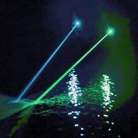
Research scientist and entrepreneur Sverre Dokken believes laser-based remote sensing has big potential in the maritime domain. But what is LADAR, who’s it for and what are the key benefits?“Our mission is to be the world leader in innovative maritime sensor products that enhance the safety and security of shipping and all manner of offshore activity,” says Ladar Ltd (LDR) principal Sverre Dokken.In the sensor vanguardEssentially a laser-based navigational aid, LADAR (Laser Detection and Ranging) combines long-distance object detection with high-accuracy measurement…
Danger Lurking: Above & Below the Surface

Feds issue Interim Guidelines for reefing old rigs at the same time that NOAA identifies myriad potentially polluting shipwrecks. Salvage opportunities abound. In late June, the U.S. Interior Department revised its interim policy for defunct, offshore oil-and-gas platforms, making it easier to turn them into artificial reefs under an initiative by the agency’s Bureau of Safety and Environmental Enforcement or BSEE. Separately, and at virtually the same time, a new NOAA report that examines national oil pollution threat from shipwrecks has been presented to the U.S. Coast Guard.
New Esri Ocean Industry Manager: Drew Stephens

Drew Stephens to lead Esri's Geographic Information Systems (GIS) for Ocean and Coastal Environments Industry. Esri has hired Drew Stephens to expand the market for GIS within the ocean industry. Esri, the world leader in GIS, has accelerated the development of its ocean technologies via the Esri Ocean GIS Initiative. As Esri's industry manager for ocean and coastal environments , Stephens will play a key role in this effort through his diverse background and GIS experience. "Stephens has worked with Esri for many years promoting the use of GIS to design sustainable practices for land and sea…
Traditional Paper Charts in Electronic Format
Seazone Solutions introduce SeaZone HydroView|Charts for use where marine data needs to be displayed rather than analysed. SeaZone HydroView|Charts offer full global coverage, having been created from digitised and geo-referenced paper charts for GIS display, human interpretation and contextual mapping. These raster map layers are available for immediate use in Geographic Information Systems for a range of applications, without the need for additional software, add-ons or plug-ins, resulting in gains in time and performance. HydroView Charts provides ideal backdrop mapping for a variety of applications from desktop to Internet. They can be also combined with existing datasets to make the display and dissemination of maps within reports or over the Internet simple and effective.
Port Awarded Grant for GIS Project
The Department of Homeland Security has awarded the Port a $542,490 grant to fund a Geographic Information Systems (GIS) and Tactical Survey Information System, which will create a digital mapping and data collection system of the Port’s facilities and infrastructure. The GIS and Tactical Survey project has two parts that integrate with one another and requires the services of two separate contractors. GIS is a digital mapping system that identifies utilities, roads, train tracks, and land use designations in a series of visual layers. The Tactical Survey will provide advanced visualization and target-folder information to port personnel and local first responders by integrating with a variety of other Port applications including security, executive management, and operations management.
NOAA Receives Funding For Electronic Charts
Congress has appointed money for the National and Atmospheric Agency (NOAA) to dramatically increase its survey and charting program. Under the Appropriations bill, NOAA’s navigation services will receive $120.2 million for Fiscal Year 2001, representing a total increase of $24 million over Fiscal Year 2001. The increased funding is in part due to the hard work of a coalition of maritime interests including AWO. A section of the bill which specifically drew focused attention from AWO and its members is the appropriation of $4.3 million for Electronic Navigational Charts (ENC). This allows NOAA to move forward with what the agency describes as “the next-generation navigational tool.” This is the first time there has been specific funding provided by Congress for ENC development.
Leica and NovAtel Will Develop Technologies For GPS
Leica Geosystems and NovAtel Inc. have entered an agreement to develop new technologies for global positioning systems (GPS). This is particularly relevant for equipment that will be based on the new upcoming Global Navigation Satellite Systems (GNSS). In the mid-eighties Leica Geosystems was one of the first companies to develop and market GPS surveying systems. NovAtel, founded in 1978, also has the reputation of being one of the most successful innovators of advanced concepts in GPS technologies. These include significant contributions to the development of Satellite Based Augmentation Systems (SBAS) such as WAAS, MSAS and EGNOS.
IXSEA Names Hoof New Sales Manager
In order to strengthen their activities in the scientific market and to branch out further into other industries such as defense, IXSEA appointed Arne Hoof as Sales Manager based in the new IXSEA subsidiary in Hannover, Germany. Arne will be developing the market for IXSEA products and managing sales in Germany. Arne holds an Engineering Diploma in Geodesy from the University of Hannover and a Certificate of Academic Proficiency in Hydrographic Surveying from the University of New Brunswick, Canada. He previously worked in customer support and software training and as project engineer at Hamburg Port Authority with CARIS Geographic Information Systems bv.
ICCL and CI Launch Project to Protect Sensitive Marine Areas
should be avoided. chaired by internationally recognized marine biologist Dr. Sylvia Earle. recognized on navigation charts. current operational practices by ICCL member lines to protect the environment. advanced wastewater purification system). cruise ship. identified by a GIS study commissioned by the science panel. biodiversity," said Dr. director of CI's Global Marine Division. recommendation can be carried out. operations. cruise industry by the seven-member independent science panel. through the U.S. practices. http://www.iccl.org. marine environment. world's oceans," said Michael Crye, ICCL president. science panel's recommendations and determine how to best implement them. wastewater discharges, storm water runoff and marine vessels.
The Marine Advanced Technology Education (MATE) Center:
The Marine Advanced Technology Education (MATE) Center, headquartered at Monterey Peninsula College in Monterey, California, is a National Science Foundation (NSF)-funded partnership of organizations concerned with marine science and technology education. The MATE Center coordinates and facilitates the development of educational programs in marine science and technology involving grades 9-16, with an emphasis on community colleges. In the Monterey Bay region, MATE and Monterey Peninsula College have developed a new Marine Science and Technology Associate Degree and Certificate Program that begins this Fall 1999 semester with courses geared to prepare students for careers in marine science and technology.
MMS Awards Contract For Royalty Reengineering
The U.S. Department of the Interior's Minerals Management Service awarded a $47 million, seven-year contract to Andersen Consulting to develop, install and operate an integrated financial system that will improve the Federal government's Royalty Management Program (RMP). With the signing of this contract, MMS fully enters the implementation phase of its reengineering initiative, which was spurred by aging computer systems, changing energy markets, and the need to place its business enterprise on business cycles and processes that better align with industry and financial institutions. The RMP, which is charged with collecting, accounting for and distributing billions of dollars in revenues associated with minerals activity on Federal and American Indian lands…
MMS Awards Contract for Royalty Reengineering
The U.S. Department of the Interior's Minerals Management Service awarded a $47 million, seven-year contract to Andersen Consulting to develop, install and operate an integrated financial system that will improve the Federal government's Royalty Management Program (RMP). With the signing of this contract, MMS fully enters the implementation phase of its reengineering initiative, which was spurred by aging computer systems, changing energy markets, and the need to place its business enterprise on business cycles and processes that better align with industry and financial institutions. The RMP, which is charged with collecting, accounting for and distributing billions of dollars in revenues associated with minerals activity on Federal and American Indian lands…
NOAA Releases New Poster of Lake Ontario Floor
A new color poster depicting features on the floor of Lake Ontario has been released by the Commerce Department's National Oceanic and Atmospheric Administration (NOAA). This is the third Great Lake to be depicted with new, highly detailed bathymetry, following Lakes Michigan and Erie. In addition to the main map, insets show details of bottom relief in part of the Rochester Basin, and in the vicinity of Charity Shoal. Also included are text explaining the geology and geomorphology of the main lake floor features, and a list of references. The bathymetry was produced with data from the entire historic hydrographic sounding database from the United States and Canada.


