

Marad: Send Gulf Transit Plans in Advance
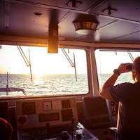
The U.S. maritime agency has told U.S.-flagged commercial vessels they should send transit plans in advance to American and British naval authorities if they intend to sail in Gulf waters following several incidents over tankers involving Iran.The seizure of commercial vessels and attacks on tankers near the Strait of Hormuz have unsettled shipping lanes that link Middle Eastern oil producers to global markets.The United States, which has increased its military forces in the region…
Ocean Alliance Calls APM Terminals Port Elizabeth
APM Terminals Port Elizabeth welcomed the 8,700 TEU capacity CMA CGM Bianca, marking the first call of the weekly Ocean Alliance US East Coast Loop 3 Service, providing direct service to the US East Coast from ports in China and Southeast Asia. After a formal welcoming ceremony held at the facility, APM Terminals Port Elizabeth hosted a reception for senior executives of Ocean Alliance member lines to commemorate the occasion. The CMA CGM Bianca arrived and departed on schedule with a berth productivity of 129.2 moves per hour (MPH) for the 4,393 container moves at the terminal, for 30.1 gross MPH, and average dwell for rail-destined containers of less than one day. Until recently, container ships calling the Port of New York & New Jersey were mainly of the 5,000-8,000 TEU size class.
Northrop Grumman Awarded US$88-Million Navy Contract
According to the US Department of Defense, Navy, Northrop Grumman Systems Corp., Charlottesville, Va., is being awarded an $88,153,800 contract to acquire integrated bridge systems and steering/ship control systems, related hardware and associated services. DoD explains that the systems are comprised of chart servers, network interface boxes, flat panel displays, radar systems, navigation software, ship control software, global positioning systems, weather sensors, depth sensors, speed sensors, digital compass systems, ship control display systems and sonar systems. These items represent a modernization upgrade from existing systems currently in use.
Lockheed Martin Awarded Contracts Two GPS lll Satellites

Lockheed Martin inform that the U.S. Air Force has awarded it more than $245 million in contract options to complete production of its seventh and eighth next-generation Global Positioning System satellites, known as GPS III. “With eight GPS III satellites now fully under contract, the GPS III program is moving from development into recurring production,” said Mark Stewart, vice president of Lockheed Martin’s Navigation Systems mission area. GPS III is an important program for the Air Force…
GPS lll Progress Report Update From Excelis

Exelis says it has successfully completed and fully tested six transmitter assemblies, which are integral payload components for the first in a series of the next generation of GPS III navigation satellites. The navigation payload transmitters carry high-powered GPS signals from space to Earth, benefitting military, commercial and civilian users. To ensure the space vehicle navigation payload meets performance requirements over the mission life, Exelis subjected the transmitter assemblies to a rigorous test program which includes random vibration…
GPS lll Satellite Build Contract Goes to Lockheed Martin
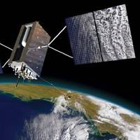
The U.S. Air Force has awarded Lockheed Martin more than US$200-million in contract options to complete production of its fifth and sixth next-generation Global Positioning System satellites, known as GPS III . Lockheed Martin explain that the GPS III improves capability to meet the evolving demands of military, commercial and civilian users. GPS III satellites will deliver three times better accuracy; provide up to eight times improved anti-jamming capabilities; and include enhancements which extend spacecraft life 25 percent further than the prior GPS block.
Mixed Messages on Monitoring and Automation Technology
A recent study found that 84% of port owners, operators and contractors said they would expect increased safety to be the primary benefit in specifying an automated system to monitor factors such as mooring line tension, approach speed and environmental conditions, according to a new independent market report by the marine systems business of Trelleborg. However, the majority (60%) of those surveyed only uses human or manual guidance at their facilities both during initial docking and mooring, and to monitor environmental conditions as the vessel continues to berth.
BAE Sees Way to Replace GPS
Military platforms commonly use Global Positioning Systems (GPS) to find their position and navigate. GPS rely upon a specific and relatively weak satellite signal that is vulnerable to disruption. Known as Navigation via Signals of Opportunity (NAVSOP), BAE Systems’ new system is able to calculate its position by making use of the hundreds of different signals that are all around us. The NAVSOP system is also able to work in the most remote parts of the world, such as the Arctic, by picking up signals that include Low-Earth-Orbit satellites and other civilian signals. By exploiting a wide range of signals, NAVSOP is resistant to hostile interference such as jamming (a particular weakness of GPS) and spoofing, where a bogus signal tricks a device into misidentifying its location.
Project Profile, Muuga Port
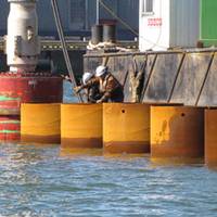
In very challenging weather conditions Danish contractor Per Aarsleff is installing its largest profile and one of its longest combination steel pile retaining walls for the extension to the container terminal in the Port of Muuga on the Gulf of Finland south coast, 17km east of the Estonian capital Tallinn. The site team, with its fleet of specialist marine plant, has been coping with freezing temperatures, strong winds and rough seas at the exposed site to accurately drive over 420 tubular steel piles up to 1.67m diameter and 45m long into the seabed.
Comms Balloon Tested Aboard USS Boxer
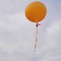
Members of the Arizona Air National Guard embarked aboard USS Boxer (LHD 4) demonstrated an advanced communication platform, the Combat SkySat balloon Dec. The most modern communication balloon platform available, the Combat SkySat is larger than a weather balloon, and has the potential to provide communications between ship and helicopter, ship to shore, and between those on shore. "There are some places between leaving ships and during insertions or raids where communication can be problematic," said Arizona Air National Guard Master Sgt. Kris Errett.
Bill Requires Pilots to Use Laptops
Rep. Ellen Tauscher, The senior Northern Californian on the House Transportation and Infrastructure Committee, introduced the Vessel Navigation and Safety Improvement Act. The legislation instructs the Coast Guard to issue regulations that require pilots to carry their own electronic chart devices, known as Portable Pilot Units, with them to provide an extra level of safety over the ship’s navigation systems. “The ecosystem of the Bay and how it affects the overall health of our communities is too important not to require the highest safety standards for navigating large container and tanker ships into San Francisco Bay, especially traffic transporting hazardous material,” said Rep. Ellen Tauscher.
Ellicott Advances Dredging Tech
Ellicott International recently unveiled details on a new type of dredge that actually walks by itself. The dredge moves on three moving spuds or traveling carriages enabling it to remain in exact position at all times because there are always two spuds firmly anchored in the bottom. It walks with the spuds while floating on the surface. This positioning allows the cutter to move forward into the next cut without losing position. This same technology also enables the dredge to move backwards to pick up contaminated material which dredging may have missed yet still remains in the same exact position to continue the forward dredging. The new swinging ladder dredge with three traveling spud carriages using no cables.
Seacor McCall Honors Engineer Colin Black

Colin Black addressing the guests at the new vessel's commissioning. The Colin B. McCall, named for noted mechanical engineer Colin Black, is a 160 by 30 ft. crew boat with an aft deck that is 91.5 by 24.75 ft. that can carry 280 long tons with about 7,000 gallons of fuel on board. Seating is provided for a total of 68 passengers with 52 of those in business class seats. Main propulsion is provided by four Cummins KTA38 M2 engines delivering 1,350 hp each in a Heavy Duty rating at 1,950 rpm for a total of 5,400 hp.
News: Seacor McCall Honors Engineer Colin Black
The Colin B. McCall, named for noted mechanical engineer Colin Black, is a 160 by 30 ft. crew boat with an aft deck that is 91.5 by 24.8 ft. that can carry 280 long tons with about 7,000 gallons of fuel on board. Seating is provided for a total of 68 passengers with 52 of those in business class seats. Main propulsion is provided by four Cummins KTA38 M2 engines delivering 1,350 hp each in a Heavy Duty rating at 1,950 rpm for a total of 5,400 hp. A Thrustmaster 75 hp electric over hydraulic bow thruster is installed in a 24-in. tunnel. Electrical service is provided by two Cummins-powered 99 kW generator sets. The vessel's U.S gross registered tonnage in under 100 tons while the International Gross tonnage is under 400 tons. It is built to U.S. Coast Guard Subchapter T/L and ABS load line.
Leica and NovAtel Will Develop Technologies For GPS
Leica Geosystems and NovAtel Inc. have entered an agreement to develop new technologies for global positioning systems (GPS). This is particularly relevant for equipment that will be based on the new upcoming Global Navigation Satellite Systems (GNSS). In the mid-eighties Leica Geosystems was one of the first companies to develop and market GPS surveying systems. NovAtel, founded in 1978, also has the reputation of being one of the most successful innovators of advanced concepts in GPS technologies. These include significant contributions to the development of Satellite Based Augmentation Systems (SBAS) such as WAAS, MSAS and EGNOS.
New Satellite System Could Find Sunken Ships
A new European Union-backed radio satellite system could help find sunken ships, EU officials said, promoting the potential benefits of the "Galileo" satellite navigation system. The EU hopes to have the system up and running by 2005 at a potential cost to taxpayers of around $2.9 billion, although the EU hopes private firms will contribute 50 percent. The EU this month secured the radio frequencies needed to launch the system at an international conference in Turkey. More detailed plans will be drawn up before the end of the year. Galileo, a European rival to military global positioning systems operated by the United States and Russia, will be able to locate objects or people to within 16.4 ft. (5 m).
Savi to Deploy Security and Tracking Network at VPA Terminals
cargo container shipments. Marine Terminal. status of RFID-tagged containers. information collected by the network infrastructure. employ its technology at our terminals," said J. executive director. information network. transporting ocean containers. security needs across the global supply chain. integrated domain awareness, port security and Secure Freight.
Technology: DPS: Expanding Options for Many Operators
Paul English, sales and business development manager for Alstom's Marine and Offshore activities, looks back at the company's role in the development of Dynamic Positioning Systems. In recent years, dynamic positioning (DP) systems have become almost as accepted a feature of certain types of marine and offshore vessels as autopilot. DP — which automatically controls a ship's heading and station keeping (either a fixed or moving target) while minimizing thruster activity — has considerably expanded the options for shipowners/operators whose vessels remain at sea for long periods of time, often in deep water and in areas where laying anchors is either not an option due to seabed structures, or impractical because of timescales.
Cape Hatteras Lighthouse Beacon to Go Dark
The beacon atop the Cape Hatteras lighthouse was extinguished, as crews prepare to move the North Carolina landmark that has stood guard over the "graveyard of the Atlantic" for more than a century. But even as sections of a granite foundation supporting the nation's tallest brick lighthouse were being cut away last week, local residents battled to block the $9.8 million move. Opponents fear when the lighthouse goes, the island's only highway will be threatened because the U.S. National Park Service has said it will no longer maintain critical groins that prevent beach erosion near the lighthouse. "They certainly aren't true to their word.
Ellicott Announces New Dredging Technology
Ellicott International offers details on a new type of dredge which actually walks by itself. The dredge moves on three moving spuds or traveling carriages enabling it to remain in exact position at all times because there are always two spuds firmly anchored in the bottom. It walks with the spuds while floating on the surface. This positioning allows the cutter to move forward into the next cut without losing position. This same technology also enables the dredge to move backwards to pick up contaminated material which dredging may have missed yet still remains in the same exact position to continue the forward dredging. The new dredge lends itself to precise dredging and positioning especially in rivers where there are currents.


