

Nautical Chart Updated for Charleston Harbor
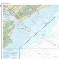
The new nautical chart 11525 extends eastward, to cover an additional pilot boarding area for vessels headed to the Charleston Harbor. Ships entering the Port of Charleston will have a new and improved nautical chart that covers a larger area to ensure safer navigational approaches into the harbor. Available on the 4th of July, new chart 11525 (Charleston Harbor Entrance and Approach) replaces the old chart 11523 (Charleston Harbor Entrance). It expands chart coverage further east, covering an additional 345 square nautical miles that wasn’t on the old chart.
NOAA: New AK Chart Makes Arctic Safer

NOAA: New Alaska navigational chart makes increased Arctic shipping safer; Kotzebue Harbor chart replaces measurements last taken in 19th century. NOAA formally presented today to Alaska officials a new nautical chart for Kotzebue Sound in the Alaskan Arctic, a sparsely charted region that is seeing increased vessel traffic because of the significant loss of summer sea ice. The new chart depicts the full range of depth measurements and object detection acquired during a full ocean bottom survey last summer by the NOAA hydrographic survey ship Fairweather.
NOAA’s Newest Chart to Support Puerto Rico Maritime Economy
The Port of San Juan, which is experiencing a tremendous growth of maritime traffic and planning for more, received an additional economic boost today when NOAA debuted a new nautical chart that will make ocean-going vessel traffic safer and more efficient through San Juan Bay and the port area. “There is not only more traffic, but larger vessels are making San Juan their port call,” said Capt. John Lowell, director of NOAA’s Office of Coast Survey. “Mariners asked for NOAA’s help when they started finding themselves too far right of the port entrance,” Lowell said. “The San Juan harbor pilots knew the ship captains were at risk of endangering their vessels.
NOAA’s New Chart Supports Puerto Rico Maritime Economy

The Port of San Juan, which is experiencing a tremendous growth of maritime traffic and planning for more, received an additional economic boost today when NOAA debuted a new nautical chart that will make ocean-going vessel traffic safer and more efficient through San Juan Bay and the port area. “There is not only more traffic, but larger vessels are making San Juan their port call,” said Capt. John Lowell, director of NOAA’s Office of Coast Survey. “Mariners asked for NOAA’s help when they started finding themselves too far right of the port entrance,” Lowell said.


