

Freire Shipyard Inks Deal to Build Oceanographic Research Vessel
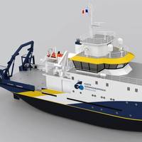
Freire Shipyard signed a contract with IFREMER - the French national institute for ocean science - for the construction of a new 40.3-m vessel for the French oceanographic fleet. It will be designed to deal with all disciplines of oceanography in Atlantic coastal areas: geosciences and paleoclimatology, physical oceanography and biogeochemistry, biological oceanography, and ecosystem functioning, from the coastline to the continental shelf. It will also perform duties related to fishery on the continental shelf and will accommodate a crew of 12 people and 10 scientists…
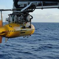
French Send Deep Diving Robot to Help Titanic Sub Search
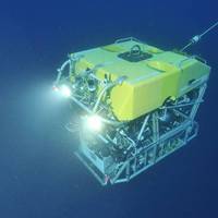
A French robot that can dive to 20,000 feet (6,000 meters) underwater is on its way to help find a tourist submersible that vanished as it descended to the Titanic wreck and it could help free the sub if it is trapped, its operator said on Wednesday.The unmanned robot, called Victor 6000, can dive deeper than other equipment now at the site in the North Atlantic and has arms that can be remotely controlled to cut cables or perform other maneuvers to release a stuck vessel, the operator said.The robot…
Missing Titanic Submersible Update: Searchers Detect Subsea Sounds
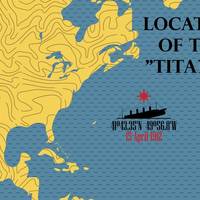
Search teams detected underwater sounds while scanning the North Atlantic for a tourist submersible that vanished with five people aboard during a deep-sea voyage to the century-old wreck of the Titanic, the U.S. Coast Guard said early on Wednesday.The detection of the sounds by Canadian aircraft on Tuesday, day three of the search, was reported by the Coast Guard as the clock ticked down to the last 24 hours of the missing craft's presumed oxygen supply.Robotic undersea search operations were diverted to the area where the sounds seemed to originate…
Polar POD Project Enters Shipyard Construction Phase in France
Ifremer, Jean-Louis Etienne and the entire Polar POD team announced its construction by the Piriou shipyards in association with 3C Metal, under the direction of the project owner, Ifremer. The scientific program of this international oceanographic "station" is being overseen by the French National Centre for Scientific Research (Centre national de la recherche scientifique, CNRS), in partnership with the French National Centre for Space Studies (Centre National d'Etudes Spatiales…
SCIENCE: Seafloor Microplastic Hotspots Controlled by Deep-sea Currents
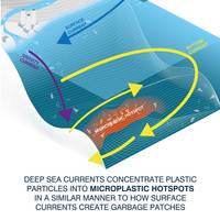
New research has revealed the highest levels of microplastic yet recorded on the seafloor, with up to 1.9 million pieces in an area of just one square metre.Published this week in the journal Science, this study shows how deep-sea currents act as conveyor belts, transporting tiny plastic fragments and fibers across the seafloor. These currents can concentrate microplastics within huge sediment accumulations, which the authors of the research term ‘microplastic hotspots’. These…
Robots Help Map England’s Deepwater Canyons
The first true three-dimensional picture of submarine canyon habitats has been produced using a combination of marine robotics and ship-based measurements. The information captured in this new set of maps ranges in scale from the 200km canyon down to the size of an individual cold-water coral polyp, and will be used to inform the management of the only English Marine Conservation Zone in deep water. This ‘nested map’ is the result of a recent scientific expedition to the Whittard Canyon in the Bay of Biscay, led by the National Oceanography Centre (NOC).
Satellite Images Reveal Ocean Acidification
Ocean acidification can now be seen from space, highlighting an ongoing danger of climate change and revealing the regions most at risk. Pioneering techniques that use satellites to monitor ocean acidification are set to revolutionize the way that marine biologists and climate scientists study the ocean. This new approach offers remote monitoring of large swathes of inaccessible ocean from satellites that orbit the Earth some 700 km above our heads. Seawater absorbs about a quarter of the carbon dioxide, a greenhouse gas that humans release into the atmosphere each year, mostly from the burning of fossil fuels, according to the National Oceanic and Atmospheric Administration (NOAA).
Satellites Reveal Worldwide Ship Traffic Up 300%

Maritime traffic on the world’s oceans has increased four-fold over the past 20 years, according to a new study quantifying global ship traffic. The research used satellite data to estimate the number of vessels on the ocean every year between 1992 and 2012. The number of ships traversing the oceans grew by 60% between 1992 and 2002. Shipping traffic grew even faster during the second decade of the study, peaking at a rate of increase of 10 percent per year in 2011. Traffic increased in every ocean during the 20 years of the study…
New Tidal Wave Energy Device Completes Sea Trials
In the continuing quest to harvest efficient, renewable energy from the power of the world’s tides, an organization called Sustainable Marine Energy’s announced that its PLAT-O tidal energy platform has successfully completed its first field trials. Despite the tremendous power and predictability of the world’s waves and tides, efforts to successfully build and bring to market a device to harness, store and transmit power in an efficient manner have been largely unsuccessful in the commercial sense.
Worldwide Ship Traffic Up 300% Since 1992
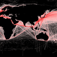
Maritime traffic on the world’s oceans has increased fourfold over the past 20 years, according to a strudy recently published by the American Geophysical Union which examined international ship traffic. The research, which used satellite data to estimate the number of vessels on the ocean every year between 1992 and 2012, found that the number of ships traversing the oceans grew by 60 percent over the time span, while shipping traffic grew even faster during the second decade of the study, peaking at rate of increase of 10 percent per year in 2011.
Dean James Wins Best Poster Prize at Ocean Business
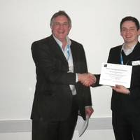
Chelsea's Technical Director, Dr. John Attridge, presented the prize for best poster to Dean James (University of Oxford) at the Microfluidics and Microsensor Sensor Technology for Oceanographic and Environmental Science Applications Workshop held during Ocean Business at NOC Southampton. The Challenger Society hosted this fascinated one-day workshop which focused on developments in microfluidics and microsensor technology for oceanographic and environmental science applications.
BV Close in Offshore Wind Agreement

Bureau Veritas says an innovative decision support system for the structural maintenance of Floating Offshore Wind Turbines (FOWTs) is close to being finalised. The initiative could result in significant cost and energy saving for all types of renewable marine energy farms. The system has been developed within the framework of Eurogia+, the Eureka cluster for low-carbon energies. The partners in this project - Bureau Veritas, Materiaal Metingen Europe, University of Liège, DN&T…
Polar Expedition Vessel the Sunken 'S.S. Terra Nova' Discovered
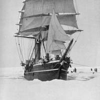
Schmidt Ocean Institute’s flagship 'R/V Falkor' locates the wreck of historic exploration ship off the coast of Greenland. During routine functional performance testing of the mutibeam mapping echosounders on the Schmidt Ocean Institute’s flagship R/V Falkor, the team aboard — including researchers from the University of New Hampshire, Ifremer, and Woods Hole Oceanographic Institution — discovered the S.S. Terra Nova, a whaler, sealer and polar exploration ship that sunk off the southern coast of Greenland in September, 1943, after being damaged by ice.
Seafuture Sponsored by Italian Trade Commission
The Italian Trade Commission and the Liguria Region are sponsoring an event in La Spezia to facilitate and create collaborations and partnerships between universities, companies, research centers, and other stakeholders in the maritime field. Seafuture will host engineers, designers, manufacturers and distributors of sea-related equipment and technology. The event will feature a number of thematic and technical seminars, forums, and meetings aimed at sharing up-to-date information and data under all institutional, technical and scientific aspects. • Eco-compatible solutions for ports, ship and coastal areas. Security and control management of anthropogenic activities. Management, control & prevention of high-risk operations, man-caused extreme natural events.
Propulsion Updates
Geislinger GmbH recently delivered its biggest torsional elastic coupling — a coupling with an outer diameter of 2.8-m and a weight of 36.3 tons. The coupling will be built into the drive line of a VLCC tanker, with an energy saving counter-rotating double propeller. More than 2,000 single parts were produced in the Geislinger works in Bad St. Leonhard and assembled in the works in Salzburg. The coupling transmits half of the 27,160 KW engine power at 74 rpm and in this way protects the gear box, which changes the direction of rotation for the backwards running propeller. This causes the energy of the swirling water in the gushing of the propeller to be used and therefore the degree of effectiveness is increased by about 14 percent.


