

Nautical Chart Updating – White Paper by OceanGrafix
OceanGrafix, the exclusive provider of NOAA print-on-demand (POD) nautical charts for U.S. waters, announces the availability of “The Creation of Accurate, Precise Charts: Understanding U.S. Nautical Chart Updates and Their Distribution.” This new white paper highlights why nautical charts are so important to mariners—including recreational boaters—and explains how a mariner can easily access chart updates. “Recreational boaters, unlike commercial mariners, are not required to carry nautical charts. But as more demands are put on our waterways, busy coasts mean more risk for accidents,” says Capt. John Lowell, director of NOAA’s Office of Coast Survey.
NOAA’s Newest Chart to Support Puerto Rico Maritime Economy
The Port of San Juan, which is experiencing a tremendous growth of maritime traffic and planning for more, received an additional economic boost today when NOAA debuted a new nautical chart that will make ocean-going vessel traffic safer and more efficient through San Juan Bay and the port area. “There is not only more traffic, but larger vessels are making San Juan their port call,” said Capt. John Lowell, director of NOAA’s Office of Coast Survey. “Mariners asked for NOAA’s help when they started finding themselves too far right of the port entrance,” Lowell said. “The San Juan harbor pilots knew the ship captains were at risk of endangering their vessels.
NOAA’s New Chart Supports Puerto Rico Maritime Economy
The Port of San Juan, which is experiencing a tremendous growth of maritime traffic and planning for more, received an additional economic boost today when NOAA debuted a new nautical chart that will make ocean-going vessel traffic safer and more efficient through San Juan Bay and the port area. “There is not only more traffic, but larger vessels are making San Juan their port call,” said Capt. John Lowell, director of NOAA’s Office of Coast Survey. “Mariners asked for NOAA’s help when they started finding themselves too far right of the port entrance,” Lowell said.
NOAA to Deliver More Charts, Faster

Revolutionary Change in NOAA Nautical Chart Production Means More Products, Faster, for Maritime Use. NOAA's development of a new navigational chart processing system, designed to meet the changing needs of the maritime community, moves into initial limited production on September 21. The new system, which slims down the current map production process while it beefs up performance, represents a technological leap forward in creating the navigational charts used to speed ships and products safety through the nation's maritime transportation system.
U.S., Arctic Coastal States Improve Nautical Charts
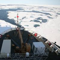
The United States joined other Arctic Coastal States in a mutual effort to develop nautical charts that will improve the safety of mariners transiting the Arctic. At a meeting in Ottawa, representatives from Canada, Denmark, Norway, Russia and the United States established a new Arctic Regional Hydrographic Commission. According to U.S. representatives at the meeting, there have been increases in ice-diminished conditions that are seen over longer periods, resulting in a doubling of vessel traffic in the Arctic since 2005.
NOAA Fairweather Updates Arctic Charts
As Arctic ice recedes, countries are looking forward to faster, safer and more efficient sea routes across the top of the world. Responding to a request from the U.S. Navy, U.S. Coast Guard, Alaska Maritime Pilots and the commercial shipping industry, NOAA sent one of its premier surveying vessels, NOAA Ship Fairweather, to detect navigational dangers in critical Arctic waters that have not been charted for more than 50 years. Fairweather, whose homeport is Ketchikan, Alaska, will spend July and August examining seafloor features, measuring ocean depths and supplying data for updating NOAA’s nautical charts spanning 350 square nautical miles in the Bering Straits around Cape Prince of Wales.


