

Chart Tile Service to Aid Charts Update
NOAA Coast Survey gives commercial navigation systems better tool to receive updated nautical charts. Accessing up-to-date nautical charts on electronic systems and mobile apps is about to get easier, as developers start adopting NOAA Coast Survey's new Chart Tile Service prototype. Navigational chart users should not notice any difference in how their charting systems operate - except that service providers will be able to quickly update the charts with hundreds of corrections applied weekly by NOAA, so users will have the corrected versions faster than ever before. Coast Survey released the NOAA prototype chart tile and metadata service on December 7.
NOAA Certifies More Printing Agents

The availability of paper "print-on-demand" nautical charts continues to expand, as NOAA's Office of Coast Survey has added three more printing companies to its roster of certified agents for paper charts. "The most recent printers to join the NOAA paper chart program represent the enduring connections between maritime tradition and progress," said Capt. Shep Smith, chief of Coast Survey's Marine Chart Division. "Companies with histories going back decades, and even centuries, support a firm foundation for the continuing production and delivery of U.S. Iver C. Weilbach & Co.
Coast Survey to Resove Magenta Line Issues
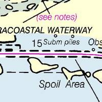
The Office of Coast Survey has announced that future editions of nautical charts of the Intracoastal Waterway will be updated to include an improved "magenta line" that has historically aided navigation down the East Coast and around the Gulf Coast. Additionally, Coast Survey will change the magenta line's function, from the perceived "recommended route" established more than a hundred years ago, to an advisory directional guide that helps prevent boaters from going astray in the maze of channels that comprise the route.
Charting Paperless Navigation in U.S. Waters
Pasha Hawaii, SeaRiver Maritime Inc., and perhaps ConocoPhillips will soon share the practice of paperless navigation in U.S. domestic trades. Each of these three ship owner/operators is managing a transition to paperless navigation at distinctly significant stages. Their progress opens a window into the evolution of electronic navigation, now taking place worldwide. There are other U.S. operators on a similar path, to be sure, but the prominence of these three is exemplary. The…
NOAA: End of Traditional Paper Nautical Charts
NOAA’s Office of Coast Survey, which creates and maintains the nation’s suite of over a thousand nautical charts of U.S. coastal waters, announced major changes ahead for mariners and others who use nautical charts. Starting April 13, the federal government will no longer print traditional lithographic (paper) nautical charts, but will continue to provide other forms of nautical charts, including print on demand charts and versions for electronic charting systems. “Like most other mariners…
Death Knell for NOAA Traditional Paper Nautical Charts
NOAA’s Office of Coast Survey has announced major changes ahead for mariners and others who use nautical charts. Starting April 13, 2014, the federal government will no longer print traditional lithographic (paper) nautical charts . NOAA will continue to provide other forms of nautical charts, including Print-on-Demand paper charts as well as electronic and digital formats. Since 1862, those lithographic nautical charts -- available in marine shops and other stores -- have been printed by the U.S. government and sold to the public by commercial vendors.
NOAA Updates Cobscook Bay Area Chart
Northern Maine vessels will be able to navigate more safely around the dangerous Cobscook Bay thanks to an updated version of the area's nautical chart issued by NOAA. The latest chart includes a new detailed illustration-called a "chart inset"-of the waters around Falls Island, providing safer passage for mariners who transit those waters. While NOAA cartographers had updated Chart 13394 (Grand Manan Channel) over the past several years, using depth measurements and obstruction locations acquired during a major hydrographic survey in 2010, a new inset was needed specifically for Falls Island. "Larger, more detailed scale coverage helps mitigate the dangers to navigation in these areas," explained Cmdr. Shep Smith, chief of NOAA Office of Coast Survey's Marine Chart Division.
US Chart No. 1 Goes Electronic
U.S. Coast and Geodetic Survey Chart No.1 has described the symbols used on paper nautical charts for 65 years. Mariners have had a standard guide for understanding the symbols, abbreviations and terms used on paper nautical charts since 1948. In a major step forward, a new edition of that guide also describes the symbols specified by the International Hydrographic Organization for the display of electronic navigational charts (ENC) on Electronic Chart Display and Information Systems (ECDIS). Several maritime nations produce their own versions of Chart 1. The U.S. Chart No.
NOAA’s Coast Survey Plans for New Arctic Nautical Charts
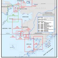
Less sea ice and more ship traffic means new charts needed for safety. NOAA’s Office of Coast Survey has issued an updated Arctic Nautical Charting Plan, as a major effort to improve inadequate chart coverage for Arctic areas experiencing increasing vessel traffic due to ice diminishment. The update came after consultations with maritime interests and the public, as well as with other federal, state, and local agencies. “As multi-year sea ice continues to disappear, vessel traffic in the Arctic is on the rise,” said Rear Admiral Gerd Glang, NOAA Coast Survey director.
Arctic Nautical Charts: NOAA Plans Updates
Less sea ice and more ship traffic means new charts needed for safety. NOAA’s Office of Coast Survey has issued an updated Arctic Nautical Charting Plan , as a major effort to improve inadequate chart coverage for Arctic areas experiencing increasing vessel traffic due to ice diminishment. NOAA plans to create 14 new charts to complement the existing chart coverage. For example, seven of the charts will complete chart coverage from the Alaska Peninsula to Cape Lisburne at the edge of the North Slope…
NOAA: New AK Chart Makes Arctic Safer
NOAA: New Alaska navigational chart makes increased Arctic shipping safer; Kotzebue Harbor chart replaces measurements last taken in 19th century. NOAA formally presented today to Alaska officials a new nautical chart for Kotzebue Sound in the Alaskan Arctic, a sparsely charted region that is seeing increased vessel traffic because of the significant loss of summer sea ice. The new chart depicts the full range of depth measurements and object detection acquired during a full ocean bottom survey last summer by the NOAA hydrographic survey ship Fairweather.
NOAA Begins Production With Esri

GIS Creates Integrated Data Workflow for More Efficient Chart Production. The National Oceanic and Atmospheric Administration (NOAA) has implemented a new nautical charting system based on Esri GIS technology to produce more navigational products than ever before without increasing its budget or personnel needs. The new system, NCS II, is based on Esri Nautical Solution, and it allows NOAA to centralize the management of hydrographic data for US coastal waters. Since accepting Esri Nautical Solution as part of its production system in 2009…


