

Jeppesen Cover ENC Major APAC Shipping Routes
Jeppesen agrees with Indonesian Navy Hydrographic Office to distribute Electronic Navigation Charts (ENC) for Indonesia including Straits of Malacca. With the completion of this agreement, Jeppesen says it will provide the worldwide commercial shipping industry with comprehensive ENC coverage for Indonesian waters — waters encompassing major Asian Pacific (APAC) trade routes critical to the flow of international commerce. Accurate and up-to-date ENCs are a vital tool for safe navigation…
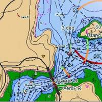
Malaysia & S.Korea Waters: Jeppesen Extends ENC Coverage
Jeppesen is now distributing official Electronic Navigation Charts (ENCs) with local partners in Malaysia and Korea. Jeppesen will distribute Royal Malaysian Navy (RMN) ENCs for Malaysia from Jeppesen’s local partner Okenos. Included in this newly available ENC coverage is the Strait of Malacca, one of the most important commercial waterways in the world. As the main channel between the Indian and Pacific Oceans, the Strait of Malacca links the major Asian economies of India, China, Japan and South Korea. It is estimated that 25 percent of all oil transported by sea passes through the Strait of Malacca, notable for its shallow waters, narrow passages and heavy shipping traffic.
Jeppesen, Brazil Forge Marine Data Agreement
Jeppesen and ’s Directorate of Hydrography and Navigation (DHN) have reached an agreement giving Jeppesen access to all of the nautical charts and data published by DHN for ’s sovereign waters. The agreement, signed through Empresa Gerencial de Projetos Navais (EMGEPRON), will allow Jeppesen to use DHN’s high quality nautical charts and data in its industry leading marine navigation products for both commercial and light marine users. With direct access to sovereign data, Jeppesen is able to ensure the highest levels of quality and integrity, thereby increasing the safety of maritime navigation. The agreement also makes possible new chart and data coverage areas for Brazilian waters.


