

ASGARD: Developing an Anti-Spoofing Weapon

Saab and GMV are collaborating in ASGARD, an EU-funded project that aims to improve maritime security when using GNSS and OSNMA. The project addresses the growing threat of GNSS spoofing and other cyberattacks on navigation systems used in the maritime industry.The ASGARD project, run by Saab and GMV, is an ambitious European Union (EU) initiative that aims to develop advanced technologies to improve Global Navigation Satellite System (GNSS) and Open Service Navigation Message Authentication (OSNMA) security in maritime environments.
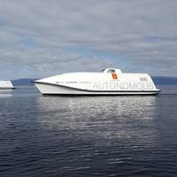
Argeo First to Operate Maritime Robotics' Mariner X Unmanned Surface Vessel
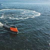
Maritime Robotics' new multi-purpose Unmanned Surface Vehicle (USV) platform, the Mariner X, is the company's most configurable and optimizable USV platform to date, built to deliver high-quality data acquisition at sea.The first operator of the new Mariner X USV platform is Argeo. Dubbed Argus, Argeo’s first unmanned survey and inspection vehicle is intended to exploit the strong demand for accurate ocean mapping, especially within the growing offshore wind market. The Argus…
Wärtsilä Unveils 'Smart' Camera System for Ships
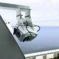
Wärtsilä Voyage has launched its Smart Panoramic Edge Camera System (S.P.E.C.S), designed to enhance marine safety by providing 360 degree situational awareness, streamed directly to the bridge in real-time.In addition to eliminating blind spots with digital panoramic cameras located around the vessel, S.P.E.C.S can also provide a birds-eye view of the ship and its surroundings, which the developer notes is a significant advantage when docking. The system’s cameras provide a calibrated range grid around the vessel to give precise measurement of distances.
Furuno's RD50 Remote Data Display Now Features 3-Axis Speed
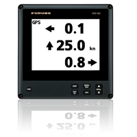
The Furuno RD50 Remote Data Display has received an upgrade with software version 1.16, introducing the new 3-Axis Speed Indication when connected to a Satellite Compass. Critical for towboats, ferries and other commercial vessels, 3-Axis Speed Indication simultaneously displays important speed information for three different points of reference: Longitudinal Speed (ahead-astern), Transverse Speed port-starboard at the stern, and Transverse Speed port-starboard from a user-determined reference point.The RD50’s 8.4" Color LCD provides a wide variety of data from onboard sensors…
Sonardyne's Sensors for Ocean Infinity's Armada USV Fleet
Ocean Infinity, a U.S. based marine survey firm developing the world's largest fleet of unmanned surface vessels - Armada - has ordered Sonardyne sensors for its robotic vessels.As reported previously, Ocean Infinity in February launched Armada, a marine technology and data company boasting the industry's largest fleet of unmanned surface vehicles (USV).Sonardyne said Wednesday it would provide the first wave of Ocean Infinity’s new Armada fleet with key sensor technologies for underwater platform navigation…
CYSEC SA Wins Maritime Cyber Security Contract
CYSEC SA, a cybersecurity company from Switzerland, has been awarded a contract by the European Space Agency (ESA) to develop a solution mitigating the cyber risks related to ship tracking using satellite communications.The digital revolution also impacts the shipping industry by integrating automated navigation, cargo-tracking systems and digital platforms which facilitate operations, trade and the exchange of data. To achieve this transformation, the mitigation of cyber security…
IMO Reviews GMDSS Requirements
International Maritime Organization (IMO)'s Sub-Committee on Navigation, Communications and Search and Rescue (NCSR) said that it will continue its ongoing work to review GMDSS requirements, to enable the use of modern communication systems in the Global Maritime Distress and Safety System (GMDSS), while removing requirements to carry obsolete systems.Search and rescue at sea depends on the integrated satellite and terrestrial radio-communication communications system - the GMDSS. The GMDSS is mandatory under the International convention for the Safety of Life at Sea (SOLAS).According to the Sub-Committee, the aim is to finalize the review in 2021, for submission to the Maritime Safety Committee (MSC), so that SOLAS amendments can be adopted for entry into force in 2024.
Autonomous Shipping – Cyber Hazards Ahead
![A look at the typical areas most frequently seen as the scene of common accidents on board workboats. (source: European Maritime Safety Agency [EMSA])](https://images.marinelink.com/images/maritime/w200h200c/a-look-at-the-typical-105797.jpg)
If autonomous vessels are the future of maritime shipping, then cyber threats may be its Achilles heel. Congested shipping, restricted visibility, limited maneuverability, and intensive docking activities all contribute to port hazards – 42 percent of EU reported marine accidents (injury/death/damage to ships) took place in port areas and 44 percent of workboat fatalities occurred on Tugs. Autonomous shipping should provide numerous benefits including increased safety by relieving crewmembers of unsafe and repetitious tasks.
Smart Navigation System

The research project Prepare Ships, led by RISE Research Institutes of Sweden, will develop a navigation system that foresees the positions of other vessels through machine learning. This reduces the risk of collisions and enables more efficient navigation. The project has recently been granted funding through the “European GNSS Agency”, GSA.A consortium of Swedish, Norwegian and German partners has now been given the go-ahead for their research and innovation project that will increase safety and efficiency in shipping.
CSSC CMC Wins MED Certificates from DNV GL
The international accredited registrar and classification society DNV GL announced the award of three Marine Equipment Directive (MED) certificates to the China State Shipbuilding Corporation Marine Technology Co., Ltd. (CSSC CMC).The MED module B certificates for Echo Sounder, Doppler Speed Log, and Global Navigation Satellite System (GNSS) were presented during the Nor-Shipping trade fair in Oslo, it said.“These three latest MED certificates represent the continuation of a long and productive cooperation between DNV GL and CSSC,” said Norbert Kray, DNV GL’s Regional Manager for Greater China. “For these latest certificates we were able to mobilize our global team and leverage the latest technologies to deliver an extremely efficient approval process.”In 2015…
UTEC Introduces New AUV Launch and Recovery System
UTEC, a global surveying company in subsea services group Acteon, recently commissioned its new launch and recovery system (LARS) for the fleet of seven autonomous underwater vehicles (AUV) it uses for seabed surveys in the oil and renewables industries.UTEC’s new LARS is a floating garage that enables an AUV to be launched and recovered without needing a small boat, thereby simplifying operations and improving safety. It also increases efficiency and reduces costs by enabling AUV surveys in parallel with construction or laying activities, as the LARS can be deployed from the same work vessel.The LARS will see its first use on a pipeline…
USCG Navigation Center: Steering a steady course for safe, secure, efficient waterways

The U.S. Coast Guard’s Navigation Center (NAVCEN) is involved in a number of activities that have an impact on all Americans, even if they don’t realize it.From motorists checking directions with their Global Positioning System (GPS) to boaters to ships coming and going to U.S. ports, the NAVCEN plays an unseen but vital role.With a staff of19 officers, 17 enlisted personnel and 19 civilians, NAVCEN falls under the Director of Marine Transportation Systems (CG-5PW) at USCG Headquarters…
EU-backed Autonomous Shipping Project Moves Forward
Hull to Hull (H2H), an EU-funded research project established to develop technical solutions for safer navigation in close proximity of other stationary or moving vessels and objects, is in its Concept Definition phase and will move on to the Technology Adaption and Integrations Work Package (WP03) this summer.H2H was established in November 2017 to develop solutions using the European Global Navigation Satellite System (EGNSS), EGNOS and Galileo, that can enhance safety in busy waters and during close maneuvering…
Inmarsat Faces US, Chinese Competition in Maritime Safety
Britain's Inmarsat will lose its monopoly in maritime safety communications after the International Maritime Organization gave Iridium and China's BeiDou Navigation Satellite System the green light to develop competing systems.Inmarsat's shares fell as much as 14 percent after U.S.-based Iridium said late Monday its network had been recognized as a provider of Global Maritime Distress & Safety System (GMDSS).The stock was trading down 9 percent at 1345 GMT, while Iridium was up 4.7 percent in New York.Inmarsat announced the approval of its own new safety service and congratulated Iridium and B
Britain Reviewing Risks to its Satellite-Reliant Infrastructure
Britain is reviewing its reliance on satellite-based technology for critical infrastructure including the Global Positioning System (GPS) as the threat of jamming attacks and disruptions grows, a government report said on Tuesday. Emergency services, transport, communications and financial networks are among key sectors which depend on Global Navigation Satellite Systems (GNSS) such as GPS. Such technology needs accurate and reliable position and timing signals. Experts say the problem with GNSS is their weak signals…
Cyber Threats Prompt Return of Radio for Ship Navigation
The risk of cyber attacks targeting ships' satellite navigation is pushing nations to delve back through history and develop back-up systems with roots in World War Two radio technology. Ships use GPS (Global Positioning System) and other similar devices that rely on sending and receiving satellite signals, which many experts say are vulnerable to jamming by hackers. About 90 percent of world trade is transported by sea and the stakes are high in increasingly crowded shipping lanes.
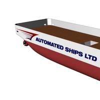
BOURBON to Support World's First Autonomous OSV Project
BOURBON entered into a Memorandum of Understanding (MOU) with Automated Ships Ltd to support the building of the world’s first autonomous, fully-automated prototype vessel for offshore operations, in collaboration with the project’s primary technology partner, KONGSBERG. BOURBON will provide detailed input to the development and design of the Hrönn project, ensuring flexibility, reliability and cost efficiency to operate safely and effectively in the offshore environment. In the second phase of the project…
World First: Unmanned Autonomous Boat for Offshore Ops
While talk of autonomous operations in the maritime sector have swirled for years, the talk becomes reality as Automated Ships Ltd. (an M Subs Ltd subsidiary) and Norway’s Kongsberg Maritime signed a Memorandum of Understanding to build the world’s first unmanned and fully-automated vessel for offshore operations. In January 2017, Automated Ships Ltd will contract the ‘Hrönn’, which will be designed and built in Norway in cooperation with KONGSBERG. Sea trials will take place…
Fugro Launches G4 Service
Fugro has further extended its technology leadership in the field of GNSS augmentation systems for offshore positioning applications with the launch of its G4 service. The new satellite correction service is the first to take advantage of all four GNSS (Global Navigation Satellite Systems): GPS, GLONASS, BeiDou and Galileo. GNSS augmentation services significantly improve position accuracy compared to unaided GNSS receivers, which are commonly used in the consumer sector. By using all available GNSS satellites, Fugro’s G4 service is designed to improve availability and reliability of offshore positioning and will thus enhance the safety and productivity of a wide range of survey and other activities offshore.
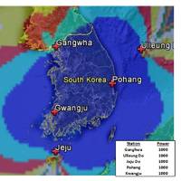
EU Pulls Plug on Back-Up Nav System
A British-led initiative to create a back-up to satellite navigation systems for ships has been pulled after failing to garner interest from other European countries, despite its proponents pointing to the growing risk of disasters at sea. Vessels increasingly rely on devices that employ satellite signals to find a location or keep exact time, including the Global Positioning System (GPS). Paper charts are used less frequently due to a loss of traditional skills among seafarers. Experts say GPS is vulnerable to signal loss from solar weather effects or radio and satellite interference or deliberate jamming, which South Korea experienced from North Korea in recent years.
Fugro Introduces G2+ Positioning Service
Fugro has introduced its high accuracy G2+ service for the GNSS augmentation field, the company announced today. The G2+ service is designed to benefit offshore operators around the globe who require positioning and measurement accuracy at the centimeter level. G2+ is an enhancement of Fugro’s G2 service (based on GPS and GLONASS) and utilizes highly advanced GNSS augmentation algorithms developed in-house. The code and carrier-phase signals transmitted by GPS and GLONASS satellites are monitored globally by Fugro’s worldwide network of reference stations. These observations are processed centrally in real-time using the company’s proprietary algorithms to generate precise corrections which are used to augment the standard signals broadcast by GPS and GLONASS satellites.
Rising from the Ashes

The federal government is now taking steps to reverse its 2010 decision to terminate the nation’s LORAN program. The LORAN program was initiated during World War II, when US and Allied forces fighting in the Pacific Theater needed a good means of navigation in that vast ocean. The US Coast Guard was charged with establishing and operating chains of Loran-A stations throughout the Pacific. With war’s end, the program was extended to coastal areas of the United States and elsewhere. Over time, Loran-A was replaced by Loran-C, which provided both greater coverage and improved accuracy.
Threats to Global Navigation Satellite Systems
Originally developed to guide Allied convoys safely across the Atlantic, the use of synchronized low frequency radio signals as a navigational aid revolutionized modern maritime navigation in the 1940s. Faced with operating ships and aircraft over vast areas, researchers pioneered the use of radio signals to aid navigation in regions where poor weather conditions made traditional methods—such as dead reckoning and celestial navigation—exceptionally difficult. This system was eventually named LORAN.


