

ASGARD: Developing an Anti-Spoofing Weapon

Saab and GMV are collaborating in ASGARD, an EU-funded project that aims to improve maritime security when using GNSS and OSNMA. The project addresses the growing threat of GNSS spoofing and other cyberattacks on navigation systems used in the maritime industry.The ASGARD project, run by Saab and GMV, is an ambitious European Union (EU) initiative that aims to develop advanced technologies to improve Global Navigation Satellite System (GNSS) and Open Service Navigation Message Authentication (OSNMA) security in maritime environments.
Wärtsilä Unveils 'Smart' Camera System for Ships
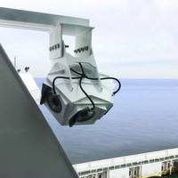
Wärtsilä Voyage has launched its Smart Panoramic Edge Camera System (S.P.E.C.S), designed to enhance marine safety by providing 360 degree situational awareness, streamed directly to the bridge in real-time.In addition to eliminating blind spots with digital panoramic cameras located around the vessel, S.P.E.C.S can also provide a birds-eye view of the ship and its surroundings, which the developer notes is a significant advantage when docking. The system’s cameras provide a calibrated range grid around the vessel to give precise measurement of distances.
Furuno's RD50 Remote Data Display Now Features 3-Axis Speed
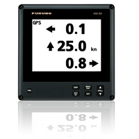
The Furuno RD50 Remote Data Display has received an upgrade with software version 1.16, introducing the new 3-Axis Speed Indication when connected to a Satellite Compass. Critical for towboats, ferries and other commercial vessels, 3-Axis Speed Indication simultaneously displays important speed information for three different points of reference: Longitudinal Speed (ahead-astern), Transverse Speed port-starboard at the stern, and Transverse Speed port-starboard from a user-determined reference point.The RD50’s 8.4" Color LCD provides a wide variety of data from onboard sensors…
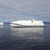
Sonardyne's Sensors for Ocean Infinity's Armada USV Fleet

Ocean Infinity, a U.S. based marine survey firm developing the world's largest fleet of unmanned surface vessels - Armada - has ordered Sonardyne sensors for its robotic vessels.As reported previously, Ocean Infinity in February launched Armada, a marine technology and data company boasting the industry's largest fleet of unmanned surface vehicles (USV).Sonardyne said Wednesday it would provide the first wave of Ocean Infinity’s new Armada fleet with key sensor technologies for underwater platform navigation…
CYSEC SA Wins Maritime Cyber Security Contract
CYSEC SA, a cybersecurity company from Switzerland, has been awarded a contract by the European Space Agency (ESA) to develop a solution mitigating the cyber risks related to ship tracking using satellite communications.The digital revolution also impacts the shipping industry by integrating automated navigation, cargo-tracking systems and digital platforms which facilitate operations, trade and the exchange of data. To achieve this transformation, the mitigation of cyber security…
IMO Reviews GMDSS Requirements
International Maritime Organization (IMO)'s Sub-Committee on Navigation, Communications and Search and Rescue (NCSR) said that it will continue its ongoing work to review GMDSS requirements, to enable the use of modern communication systems in the Global Maritime Distress and Safety System (GMDSS), while removing requirements to carry obsolete systems.Search and rescue at sea depends on the integrated satellite and terrestrial radio-communication communications system - the GMDSS. The GMDSS is mandatory under the International convention for the Safety of Life at Sea (SOLAS).According to the Sub-Committee, the aim is to finalize the review in 2021, for submission to the Maritime Safety Committee (MSC), so that SOLAS amendments can be adopted for entry into force in 2024.
Autonomous Shipping – Cyber Hazards Ahead
![A look at the typical areas most frequently seen as the scene of common accidents on board workboats. (source: European Maritime Safety Agency [EMSA])](https://images.marinelink.com/images/maritime/w200h200c/a-look-at-the-typical-105797.jpg)
If autonomous vessels are the future of maritime shipping, then cyber threats may be its Achilles heel. Congested shipping, restricted visibility, limited maneuverability, and intensive docking activities all contribute to port hazards – 42 percent of EU reported marine accidents (injury/death/damage to ships) took place in port areas and 44 percent of workboat fatalities occurred on Tugs. Autonomous shipping should provide numerous benefits including increased safety by relieving crewmembers of unsafe and repetitious tasks.
Smart Navigation System

The research project Prepare Ships, led by RISE Research Institutes of Sweden, will develop a navigation system that foresees the positions of other vessels through machine learning. This reduces the risk of collisions and enables more efficient navigation. The project has recently been granted funding through the “European GNSS Agency”, GSA.A consortium of Swedish, Norwegian and German partners has now been given the go-ahead for their research and innovation project that will increase safety and efficiency in shipping.
CSSC CMC Wins MED Certificates from DNV GL
The international accredited registrar and classification society DNV GL announced the award of three Marine Equipment Directive (MED) certificates to the China State Shipbuilding Corporation Marine Technology Co., Ltd. (CSSC CMC).The MED module B certificates for Echo Sounder, Doppler Speed Log, and Global Navigation Satellite System (GNSS) were presented during the Nor-Shipping trade fair in Oslo, it said.“These three latest MED certificates represent the continuation of a long and productive cooperation between DNV GL and CSSC,” said Norbert Kray, DNV GL’s Regional Manager for Greater China. “For these latest certificates we were able to mobilize our global team and leverage the latest technologies to deliver an extremely efficient approval process.”In 2015…
EU-backed Autonomous Shipping Project Moves Forward
Hull to Hull (H2H), an EU-funded research project established to develop technical solutions for safer navigation in close proximity of other stationary or moving vessels and objects, is in its Concept Definition phase and will move on to the Technology Adaption and Integrations Work Package (WP03) this summer.H2H was established in November 2017 to develop solutions using the European Global Navigation Satellite System (EGNSS), EGNOS and Galileo, that can enhance safety in busy waters and during close maneuvering…
Inmarsat Faces US, Chinese Competition in Maritime Safety
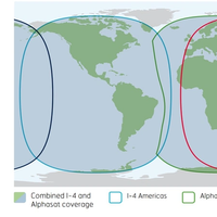
Britain's Inmarsat will lose its monopoly in maritime safety communications after the International Maritime Organization gave Iridium and China's BeiDou Navigation Satellite System the green light to develop competing systems.Inmarsat's shares fell as much as 14 percent after U.S.-based Iridium said late Monday its network had been recognized as a provider of Global Maritime Distress & Safety System (GMDSS).The stock was trading down 9 percent at 1345 GMT, while Iridium was up 4.7 percent in New York.Inmarsat announced the approval of its own new safety service and congratulated Iridium and B
Safeguarding GPS When Global Positioning Doesn’t Work

Suppose the Global Positioning System (GPS) receivers used for your vessel, offshore oil platform, or port facility could not generate position data needed for your operations. How would your crew or staff respond? Initial troubleshooting efforts may indicate equipment failures, antenna masking, or possibly human error. Additionally, the lack of position data will likely force your crew or staff to resort to secondary means to obtain position information. If position data cannot be regained, then the receivers may have lost GPS due to intentional or unintentional interference.
MSC Approves SOLAS Amendments
The International Maritime Organization’s (IMO) Maritime Safety Committee (MSC), which met at the Organization's London headquarters for its 94th session, from November 17-21, 2014, approved draft SOLAS amendments to make mandatory the International Code of Safety for Ships using Gases or other Low- flashpoint Fuels (IGF Code); adopted other SOLAS amendments; continued its work on its action plan on passenger ship safety; and approved and adopted a number of items put forward by the subcommittees. The MSC also adopted the Polar Code and related amendments to the International Convention for the Safety of Life at Sea (SOLAS) to make it mandatory.
Europe Grapples with Threat of Ships Sailing Blind
Europe has yet to fully wake up to the danger of maritime disasters caused by signal jamming and blackouts of satellite navigation devices, say the proponents of a back up system on trial in British and Dutch ports. Ships increasingly rely on systems that employ satellite signals to find a location or keep exact time including the Global Positioning System (GPS) and GLONASS. But experts say such systems are vulnerable to signal loss from solar weather effects or radio and satellite interference and can also be affected by intentional jamming by criminal gangs, nation states or potentially from militant groups. The General Lighthouse Authorities of the UK and Ireland (GLA) is pioneering a radio-based back-up prototype called eLoran.
McMurdo Completes Techno-Sciences Acquisition
Strategic acquisition validates Orolia's McMurdo Group as premier supplier of COSPAS-SARSAT search and rescue solutions, establishes U.S. McMurdo Group, a global company in end-to-end search and rescue (SAR) and maritime domain awareness (MDA) solutions, today announced the successful acquisition of Techno-Sciences, Inc. (TSi), a provider of SAR satellite ground stations, integrated emergency response center systems and coastal surveillance solutions. Terms of the acquisition were not disclosed. TSi’s Beltsville, Maryland location becomes the U.S. Headquarters for McMurdo Group, a division of Orolia (NYSE Alternext Paris – FR0010501015 – ALORO), global specialist in critical Global Navigation Satellite System solutions.
Orolia, Transas Partner to Offer e-Maritime Solutions
Orolia (NYSE Alternext Paris – FR0010501015 – ALORO), global specialist in critical Global Navigation Satellite System solutions, and Transas Group, global leader in maritime simulation, navigation and surveillance systems, today announced that they have signed a Memorandum of Understanding whereby they will jointly develop new solutions to address the maritime industry’s need for high-end e-maritime systems that integrate the latest in Maritime Domain Awareness (MDA) and Search and Rescue (SAR) functionality. Under the terms of the agreement, the two groups will leverage complementary products, state-of-the-art technologies and in-depth expertise in vessel management, asset protection and emergency response to create innovative solutions that continue to save lives and improve operations.
e-Navigation: Multi-GNSS Receiver Chips Coming
Furuno say new multi-GNSS (Global Navigation Satellite System) receiver chips "eRideOPUS 6" and "eRideOPUS 7" will be available from summer 2013. The new receiver chips are multi-GNSS compliant single-chip LSIs, capable of concurrently receiving signals from multiple satellites of GNSS systems, i.e., GPS, GLONASS, Galileo, etc., and Satellite-Based Augmentation Systems (SBAS) as well as Japan's Quasi-Zenith Satellite System (QZSS). The ability to concurrently receive GNSS and GNSS augmentation signals from multiple satellites belonging to different satellite services means that the receivers have a higher probability of acquiring a greater number of satellites at any single point in time.
China Plan 2020 World Satnav Coverage
China's navigation system BeiDou (with 16 satellites up at present) is expected to achieve full-scale global coverage by around 2020. The BeiDou Navigation Satellite System (BDS) will then be able to provide highly accurate and reliable positioning, navigation and timing service with the aid of a constellation of 35 satellites, reports Xinhua. China started to build up its own space-based Positioning, Navigation and Timing system in 2000 by launching the first satellite for an experimental version of the BeiDou which has since started providing licensed services for China's government and military users in transport, weather forecasts, fishing, forestry, telecommunications, hydrological monitoring and mapping.
Shipping Fairways NW Australia Discussed at AMSA Meeting
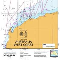
The third meeting of the Navigation Safety Advisory Group (NSAG) recently met to consider safety of navigation concerns in Australian waters. (NSAG is the peak consultative body for matters relating to the Australian Maritime Safety Authority's (AMSA) responsibilities for the safety of navigation in Australian waters). The meeting attracted 24 navigation practitioners and representatives from the Australian Hydrographic Service, port and state marine authorities, industry peak bodies, shipping companies and marine pilots.
Russia Offers India GLONASS Deal
The Global Navigation Satellite System (GLONASS), which was officially launched in 1993, is a Russian counterpart to the U.S. Global Positioning System (GPS). It fixes the location and speed of surface, sea and air objects to within an accuracy of one meter. Russia and India have been cooperating on use of GLONASS for more than four years, but Russia has not previously offered equal joint participation in upgrading the system. Deputy Prime Minister Dmitry Rogozin, who has special responsilibity for Russia's military-industrial complex, said: "We have offered our Indian counterparts not only use of the Glonass system but also participation in upgrading it. We practically see it as a joint effort.
Esri GPS Base Station Joins National Network
Esri recently installed a GPS base station to assist its GIS developers and to support surveyors, engineers, scientists, and those in public works and public safety in the community surrounding the Esri campus in Redlands, California. The base station, named GISA, has been accepted by the National Geodetic Survey (NGS) and incorporated into the national Continuously Operating Reference Station (CORS) network. "GPS, originally designed as a US Department of Defense system, has become part of everyday life, with the technology in all types of devices from smartphones to shipping containers," said Brent Jones, Esri surveying and engineering industry manager.
LightSquared Outlines Plan to Avoid GPS Interference

Marine electronics industry still has major concerns. An official of LightSquared, the company that has been under fire for its plan to offer mobile satellite services that could seriously interfere with Global Positioning System (GPS) signals, told a gathering at the 2011 NMEA International Marine Electronics Conference & Expo that solutions were in the works to prevent disruptions from occurring. “Our integrated network will bring great benefits to wireless users nationwide, but at the same time we’re committed to ensuring this service doesn’t interfere with any GPS devices.
European Global Navigation Satellite System
The UK Department for Transport summarized the Department’s work on the European Global Navigation Satellite System programs Galileo and EGNOS. Galileo is the European Union’s global navigation satellite system (GNSS) and will be fully interoperable with the US GPS system. The European Geostationary Navigation Overlay Service (EGNOS) is the first pan-European satellite navigation system. It augments GPS, making it more suitable for safety-critical applications, such as navigating ships through narrow channels. (9/16/10). (Source: Bryant’s Maritime News)


