

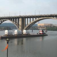
Sensor Systems Improve Marine Navigation Near US Naval Bases
Maritime navigational safety near two U.S. Navy installations in Kings Bay, Ga., and Portsmouth, N.H. has been improved thanks to new Physical Oceanographic Real-Time Systems, also known as PORTS, installed by NOAA and the U.S. Navy. They are the first new PORTS in two years, and the 34th and 35th in the nationwide network.The system near Naval Submarine Base Kings Bay, the East Coast home to America’s Ohio-class submarines, is an integrated series of sensors which will provide critical real-time information on oceanographic and meteorological conditions.
E-Navigation is the Future of Shipping

Trading worldwide without electronic tools is no longer an option, young navigators and crew are switched on to digital technology and they want to have this new technology at their fingertips rather than the messy, slow and labour and paper-intensive methods of the past.Tor Svanes, the founder and CEO of NAVTOR, believes that electronic chart and display information systems (ECDIS) is now a must have navigational tool in the modern era.ECDIS has become the modus operandi on all ships…
Trelleborg's Safepilot for Shell's Brent Data Decommissioning Project
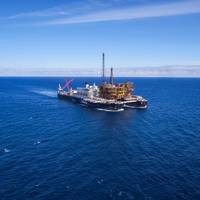
SafePilot from Trelleborg’s marine systems operation helped to pilot Allseas’ 200 meter-long barge, Iron Lady, from the Tees Bay to Able UK’s Seaton Port in Hartlepool which transported Shell’s 24,200 ton Brent Delta topside to Able’s facility on May 2, 2017.The Shell-operated Brent field, is located 115 miles east of the Shetland Islands, in 140 meters water depth, and has been in production since 1976. As part of Shell’s complex Brent Decommissioning Project, the Brent Delta topside, was lifted from the concrete legs of the Gravity Base Structure using innovative single lift technology.
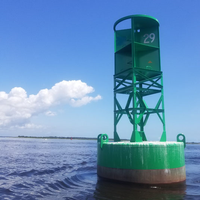
Buoy Shot and Sunk off Block Island
A U.S. Coast Guard crew was conducting regular aids-to-navigation maintenance when they found a buoy submerged near Block Island, R.I. When the crew raised the 12,000-pound buoy on Monday, they discovered it was riddled with 20 bullet holes. Clay Head buoy number 7 marks a large rock three feet below the water's surface and is supposed to be key navigational tool for mariners. Instead it turned into a navigational hazard on a route frequently transited by ferries providing critical supplies to Block Island.
Polferries, Sup4Nav Ink Navdec system Deal
The Navdec system designed to improve safety of passengers and freight and aimed to support navigators in collision situations was tested on board the ferry m/f Wawel and m/f Mazovia in 2016. This invention will also be installed now on m/f Baltivia sailing from Świnoujście to Ystad. Polferries decided to equip all ferries with Navdec system to improve safety of passengers and freight. Accordingly, an agreement to this effect was signed between Polferries and Sup4Nav on 8th of December 2016 in Kołobrzeg. The navigational decision support system NAVDEC is the first navigational tool worldwide that performs information functions as well as those typical of decision support systems.
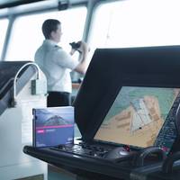
ECDIS: The Quiet Revolution in Maritime Navigation
Driven by the SOLAS-mandated transition to ECDIS, the adoption of digital navigation is the most visible sign of how navigational practices are being transformed. Additional tools are also playing an important role in supporting bridge teams and delivering accurate navigational information to the bridge. We are now halfway through the transition period under the timetable set out in the amendments to the SOLAS Convention adopted in 2009, requiring the mandatory carriage of ECDIS for ships engaged on international voyages.
AIS Regulations: New Responsibilities and Opportunities
March Coast Guard deadline represents milestone for AIS use in U.S. From increasing situational awareness and enhancing the safety and security of maritime transportation, to its use in accident investigation, search and rescue, Aids to Navigation and asset monitoring, the role of AIS (Automatic Identification System) as a flexible and developing technology continues to grow in significance. The month of March 2016 – has come and gone – and represents an important milestone which will increase the prevalence and general awareness of AIS.
SevenCs Supports MariGreen Project
SevenCs is part of the EU INTERREG V A cross-border project “MariGreen” to support the maritime industry in the transition towards more efficient, greener and more sustainable shipping. The MariGreen project develops innovations for greener and low-emission shipping and supports in particular small and medium enterprises. There are 12 innovation projects behind "MariGreen" that are dealt with by a total of 59 partners located in the Netherlands and Germany. Alternative fuel for ships, Wind Energy Systems for freight and passenger shipping, improvement of logistics operations, resource-efficient ship operations and safety issues in nautical education and training are among the main topics. SevenCs engages in the MariGreen work stream “Wind propulsion in commercial shipping”.
MAST, WESMAR Partner on Maritime Security

A new partnership between maritime security company MAST and marine sonar systems provider WESMAR has been established to protect super yachts and the maritime industry from security risks. Phil Cable, CEO of MAST, said: “Global threats to assets and personnel operating in the maritime environment are complex and continually evolving. WESMAR President Bruce Blakey said: “Our sonar technology is used as a navigational tool for obstacle avoidance and other underwater threats. In addition to being an asset to vessels…
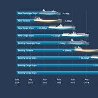
Majority of Global Tanker Fleet Yet to Adopt ECDIS
The majority of ships in the global tanker fleet have yet to adopt ECDIS, according to data published for the first time by the United Kingdom Hydrographic Office (UKHO). The SOLAS regulations on the mandatory carriage of ECDIS will come into force from July 1, 2015 for all tankers over 3,000 gross metric tons, apart from permitted exemptions. Over 8,500 tankers will be required to comply with these rules and, with less than 10 months to go, the UKHO can reveal that 58% of these ships do not yet use an ENC service.
UK's Portsmouth Pilots Choose SevenCs Navigational Tool
The providers of the system, SevenCs inform that after a series of trials with different Portable Pilot Units (PPU) the Portsmouth Pilots have selected ORCA Pilot G2 as their navigation tool of choice. The new software is produced by SevenCs, the leading maritime software development company for navigation and chart production. With Centerprise International as the local distributor for the UK, customers can rely on a strong partner with a proven track record for governmental and public service IT projects. Ben McInnes, Deputy Harbour Master and Portsmouth Pilot said: “The new software is easy to use and offers amazing capabilities. The SevenCs solution offers the pilot organization a maximum of freedom in selecting their preferred hardware and sensors.
FAST 2011: Focuses on Future of Fast Sea Transportation
Naval Architects and marine engineers from around the world gathered in Honolulu in September for the 11th International Conference on Fast Sea Transportation (FAST 2011). The four-day biannual symposium promoted world-wide cooperation among scientists and engineers involved with all aspects of the high-speed maritime industry. FAST 2011 was the Fast Foundation’s 20th anniversary. Kjell Holden of the Norwegian Univ. of Science and Technology and FAST International Standing Committee…
NOAA Receives Funding For Electronic Charts
Congress has appointed money for the National and Atmospheric Agency (NOAA) to dramatically increase its survey and charting program. Under the Appropriations bill, NOAA’s navigation services will receive $120.2 million for Fiscal Year 2001, representing a total increase of $24 million over Fiscal Year 2001. The increased funding is in part due to the hard work of a coalition of maritime interests including AWO. A section of the bill which specifically drew focused attention from AWO and its members is the appropriation of $4.3 million for Electronic Navigational Charts (ENC). This allows NOAA to move forward with what the agency describes as “the next-generation navigational tool.” This is the first time there has been specific funding provided by Congress for ENC development.


