

New Lineup for NOAA Hydrographic Services Panel
NOAA administrator Kathryn Sullivan, Ph.D., has appointed six members to the Hydrographic Services Review Panel, a federal advisory committee that gives NOAA independent advice for improving a range of services and products that support navigation and coastal resilience. Capt. “Providing coastal communities, boaters, and the commercial maritime industry with timely, reliable, accurate, and authoritative information is essential as we strive to keep commerce flowing through our nation’s ports,” Sullivan said. Rear Admiral Ken Barbor (ret.), U.S. Lawson W. Capt. Gary A. Scott R.
NOAA: US to See More Floods from Sea Level Rise

Most of U.S. coast may see 30 or more days a year of floods up to 2 feet above high tides. By 2050, a majority of U.S. coastal areas are likely to be threatened by 30 or more days of flooding each year due to dramatically accelerating impacts from sea level rise, according to a new NOAA study, published in the American Geophysical Union’s online peer-reviewed journal Earth’s Future. The findings appear in the paper From the Extreme to the Mean: Acceleration and Tipping Points for Coastal Inundation due to Sea Level Rise…
Jacksonville Adds PORTS Real-time Data System
Officials from NOAA, the Jacksonville Marine Transportation Exchange, and the Jacksonville Port Authority officially dedicated a new information system today which will increase safety for ships using the St. Johns River. The system, called Physical Oceanographic Real-Time System (PORTS), provides real-time information on water levels, currents, meteorological conditions, and under-bridge clearance, giving users critical information when traveling through the river. The St. Johns River in Jacksonville will become the 23rd location to use the system and is the second largest PORTS ever established. “Our nation’s ports are critical cogs in our country’s economic engine,” said Kathryn D. Sullivan, Ph.D., under secretary of commerce for oceans and atmosphere and NOAA administrator.
NOAA Offers a New Way to See Currents
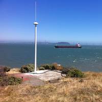
A new NOAA National Ocean Service website will provide mariners near real-time coastal ocean surface current observations and tidal current predictions in coastal waters using high frequency (HF) radar, making marine navigation safer for mariners and commercial shippers. The web-based observations are now available for the Chesapeake and San Francisco Bays in areas vital for marine navigation, with additional locations to follow. The product was made possible by NOAA’s Center for Operational Oceanographic Products and Services (CO-OPS) using data from the NOAA-led U.S.
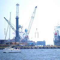
New, New York Harbor Current Meter
NOAA uses data from a new current meter in New York harbor operated by New Jersey’s Stevens Institute of Technology. The system provides enhanced real-time information to mariners travelling through the nation’s second busiest port. The Stevens current meter measures the direction, speed, and volume of ocean currents in the harbor’s navigation channels, north of the Narrows between Brooklyn and Staten Island. Its data will be used in NOAA’s Physical Oceanographic Real-Time System (PORTS®) system…
NOAA Study Investigates El Nino Effects
Coastal communities along the U.S. East Coast may be at risk to higher sea levels accompanied by more destructive storm surges in future El Niño years, according to a new study by NOAA. The study was prompted by an unusual number of destructive storm surges along the East Coast during the 2009-2010 El Niño winter. The study, led by Bill Sweet, Ph.D. from NOAA’s Center for Operational Oceanographic Products and Services, examined water levels and storm surge events during the ’cool season’ of October to April for the past five decades at four sites representative of much of the East Coast: Boston, Atlantic City, N.J., Norfolk, Va., and Charleston, S.C.
NOAA Installs System to Improve Safety & Efficiency
Ship captains and pleasure boaters can now get free real-time information on water and weather conditions for Cherry Point, Wash., from a newly installed NOAA ocean observing system that makes piloting a ship safer and more efficient. The NOAA Physical Oceanographic Real-Time System (PORTS) at Cherry Point provides observations of tides, currents, water and air temperature, barometric pressure and winds. Collected from a variety of sensors in and around the port, the data is available online and by phone: 888-817-7794 (toll-free).
Sea Level Anomaly Along U.S. Atlantic Coast
Persistent winds and a weakened current in the Mid-Atlantic contributed to higher than normal sea levels along the Eastern Seaboard in June and July, according to a new NOAA technical report. After observing water levels six inches to two feet higher than originally predicted, NOAA scientists began analyzing data from select tide stations and buoys from Maine to Florida and found that a weakening of the Florida Current Transport—an oceanic current that feeds into the Gulf Stream—in addition to steady and persistent Northeast winds, contributed to this anomaly. “The ocean is dynamic and it’s not uncommon to have anomalies,” said Mike Szabados, director of NOAA’s Center for Operational Oceanographic Products and Services.
NOAA PORTS Installed in Mobile Bay
Mobile, Ala. has become the 14th location in the United States to install the Physical Oceanographic Real-Time System. that can reduce the risk of vessel groundings and increase the amount of cargo moved through the port. The system will become operational on Dec. Operational Oceanographic Products and Services, PORTS measures, integrates, and disseminates observations of water levels, currents, salinity, wind, and bridge clearance. dredged channel depth. Port of Mobile PORTS data are updated every six minutes and thoroughly quality controlled to ensure accuracy. marine transportation community, the data are freely accessible on the Internet at http://www.tidesandcurrents.noaa.gov/ports. NOAA PORTS information users include port authorities, vessel pilots, shipping companies, U.S.


