

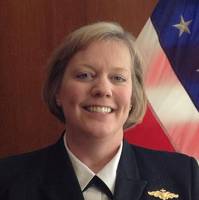
Rear Admiral Hann Confirmed to NOAA Leadership Post
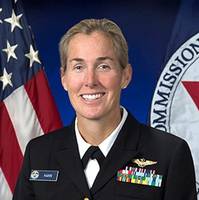
The U.S. Senate confirmed on Tuesday evening President Biden’s nomination of NOAA Rear Admiral Nancy Hann to lead the NOAA Office of Marine and Aviation Operations (OMAO) and NOAA Commissioned Officer Corps (NOAA Corps), one of the nation’s eight uniformed services.“From flying into hurricanes to crewing remote explorations to the deepest depths of the ocean, the NOAA Corps drives NOAA’s science forward,” said U.S. Secretary of Commerce Gina M. Raimondo. “Rear Admiral Hann’s leadership…
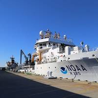
Thoma-Sea Marine Wins Deal to Build Pair of NOAA Oceanographic Ships
NOAA’s effort to recapitalize its aging fleet of research ships took a major step forward today with the U.S. Navy’s award of a $178,082,877 contract to Thoma-Sea Marine Constructors LLC, Houma, La., for the detailed design and construction of two new oceanographic ships.NOAA is acquiring the vessels through an agreement with the Naval Sea Systems Command, a leader in building, providing and procuring large research ships for the nation's research fleet.The first ship, to be named Oceanographer, will be homeported in Honolulu.
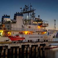
NOAA Sets Up Vessel Ops Support in Rhode Island
NOAA has awarded a lease to Massa Industries, LLC for office space in Middletown, R.I., that will temporarily house a new marine operations support facility for Rhode Island-based NOAA ships Henry B. Bigelow and Okeanos Explorer.The Middletown facility will also support NOAA personnel engaged in the design and construction of a new pier for the two ships and a permanent NOAA marine operations support facility at Naval Station Newport. NOAA expects to occupy the interim facility in the fall of 2020 and relocate it to the naval station in 2023.“With an expanded presence in Rhode Island…
NOAA to Order New Research Ships in 2020
The U.S.' National Oceanic and Atmospheric Administration (NOAA) said it expects to award contracts for the construction of two new oceanographic ships by the end of the year. Once in service, the new large oceangoing, multi-mission research vessels will support missions ranging from general oceanographic research and exploration to marine life, climate and ocean ecosystem studies, NOAA said.“When completed, these new state-of-the-art ships will be vital for collecting high-quality data and leading scientific discoveries,” said Neil Jacobs, Ph.D., acting NOAA administrator.
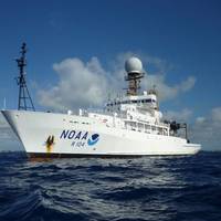
NOAA Deploys Survey Ships for Arctic Charting Projects
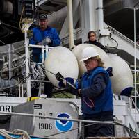
NOAA announced the official launch of its 2015 Arctic hydrographic survey season took place this morning, in Kodiak, Alaska, in a World Ocean Day ceremony which showcased the deployment of the NOAA ships Rainier and Fairweather. “Most Arctic waters that are charted were surveyed with obsolete technology, with some of the information dating back to Captain Cook's voyages, long before the region was part of the United States,” said NOAA deputy under secretary for operations Vice Admiral Michael S. Devany in remarks directed to the crews of NOAA ships.
NOAA to Explore Depths of Caribbean Sea
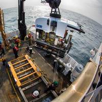
Public can watch seafloor discoveries live online April 9-30. Beginning April 9, scientists aboard NOAA Ship Okeanos Explorer will begin a series of 20 dives to investigate previously unseen depths of the Caribbean Sea and Atlantic Ocean – and the public can follow along online. During dives that are expected to go as deep as 3.7 miles, a sophisticated unmanned submarine, called a remotely operated vehicle, or ROV, will broadcast live video from the seafloor, allowing anyone with Internet access to watch the expedition as it unfolds.
NOAA to Boost Arctic Nautical Charting
NOAA plans increased 2015 Arctic nautical charting operations, coordinating with U.S. As commercial shipping traffic increases in the Arctic, NOAA informs it is taking steps to update nautical charts in the region. NOAA’s Office of Coast Survey will use data collected by two of its own ships, Rainier and Fairweather, as well as the U.S. Coast Guard cutter Healy and a private sector hydrographic contractor to cover nearly 12,000 nautical miles in the Arctic for use in updating its navigational charts.
Lynch Takes Helm of NOAA’s Atlantic Fleet
NOAA Capt. Anne K. Lynch has assumed command of the agency's Marine Operations Center-Atlantic in Norfolk, Va., which manages the day-to-day operations of the nine research and survey ships in NOAA's Atlantic fleet. Each year these ships conduct dozens of missions to assess fish and marine mammal stocks, conduct coral reef research, collect seafloor data to update nautical charts, and explore the ocean. Lynch relieves NOAA Corps officer Anita Lopez, who has served as the center's commanding officer since June 2012.
NOAA: New AK Chart Makes Arctic Safer
NOAA: New Alaska navigational chart makes increased Arctic shipping safer; Kotzebue Harbor chart replaces measurements last taken in 19th century. NOAA formally presented today to Alaska officials a new nautical chart for Kotzebue Sound in the Alaskan Arctic, a sparsely charted region that is seeing increased vessel traffic because of the significant loss of summer sea ice. The new chart depicts the full range of depth measurements and object detection acquired during a full ocean bottom survey last summer by the NOAA hydrographic survey ship Fairweather.
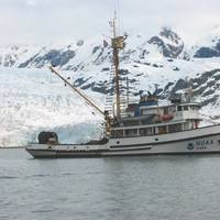
NOAA Ship Rainier Returns to Alaska for Sea Floor Surveys
NOAA Ship Rainier returns to Alaska to conduct sea floor surveys in support of safe navigation. NOAA Ship Rainier has begun a month long survey of the sea floor near Alaska’s Prince of Wales Island as part of a multi-year effort to update nautical charts for the area. In addition to supporting marine navigation, data acquired by the 231-foot hydrographic survey vessel will also support marine ecosystem studies and improve inundation models for areas vulnerable to tsunamis. “We are pleased to return to Alaska to continue these important surveys…
NOAA's Thomas Jefferson Conducting Surveys
NOAA Ship Thomas Jefferson conducts sea floor surveys to keep shipping safe along Long Island coast. NOAA Ship Thomas Jefferson continues today on a three-month survey of the sea floor off the coast of New York, Connecticut and Rhode Island, as part of a multi-year effort to update nautical charts for Block Island Sound and keep large ships and commerce moving safely. In addition to supporting marine navigation, data acquired by the 208-foot hydrographic survey vessel will also support a seafloor mapping initiative by Connecticut and New York.
NOAA Fairweather Departs on Survey Mission
NOAA Ship Fairweather, a 231-foot survey vessel, departed Kodiak, Alaska, today on a mission to conduct hydrographic surveys in remote areas of the Arctic where depths have not been measured since before the U.S. bought Alaska in 1867. NOAA will use the data to update nautical charts to help mariners safely navigate this important but sparsely charted region, which is now seeing increased vessel traffic because of the significant loss of Arctic sea ice. Over the next two months, Fairweather will conduct hydrographic surveys covering 402 square nautical miles of navigationally significant waters in Kotzebue Sound, a regional distribution hub in northwestern Alaska in the Arctic Circle.
NOAA’s Fairweather Maps Bering Straits
Responding to a request from the U.S. Navy, U.S. Coast Guard, Alaska Maritime Pilots and the commercial shipping industry, NOAA sent one of its surveying vessels, NOAA Ship Fairweather, to detect navigational dangers in critical Arctic waters that have not been charted for more than 50 years. Fairweather, whose homeport is Ketchikan, Alaska, will spend July and August examining seafloor features, measuring ocean depths and supplying data for updating NOAA’s nautical charts spanning 350 square nautical miles in the Bering Straits around Cape Prince of Wales.
NOAA, Navy Monitor Ocean Conditions Near Spill
NOAA Ship Thomas Jefferson is underway on a mission to deploy a variety of U.S. Navy ocean monitoring instruments in the vicinity of the BP Deepwater Horizon oil spill. The floats, drifters and autonomous underwater vehicles will aid researchers in monitoring the surface and deep currents that are distributing the oil. Of particular interest is the Loop Current and its potential to spread the oil to a much wider area. “NOAA is proud to partner with the U.S. Navy in the ongoing…
$73.6M New NOAA Fisheries Survey Vessel
NOAA awarded a $73.6m American Recovery and Reinvestment Act contract to Marinette Marine Corporation located in Marinette, Wis., for the construction of a new fisheries survey vessel, which will dramatically improve NOAA’s ability to conduct surveys for fish, marine mammals and turtles off the U.S. West Coast and in the eastern tropical Pacific Ocean. The vessel will be the fifth in a series of state-of-the-art Oscar Dyson-class ships built for the agency. “Our fisheries and marine ecosystems are critical to our nation’s economy,” said Jane Lubchenco, Ph.D., under secretary of commerce for oceans and atmosphere and NOAA administrator.
NOAA's 15-Year Plan to Invest in Ships
15 years. scientists. Vice Admiral Conrad C. commerce for oceans and atmosphere and NOAA administrator. arrived at NOAA in 2001, the average age of our fleet was 32 years. next 15 years. to systematically replace or upgrade the fleet. ocean and climate studies. not found in the commercial fleet. on Aug. 13. Bell M. Shimada, which will be homeported on the West Coast. Marine and Aviation Operations. personnel.
NOAA's Oldest Ship Retired
NOAA ship John N. Cobb, the oldest and only wooden hulled ship in the NOAA fleet, was decommissioned in after 58 years of service. The 93-ft. fisheries research vessel began service in 1950 with the Bureau of Fisheries, predecessor to NOAA's Fisheries Service, conducting albacore tuna surveys in , , and . Homeported in , Cobb has operated primarily in Alaskan waters for much of her service life, most recently in support of the fisheries service's Auke Bay Laboratories in . "The John N. Cobb has been an extremely productive platform for NOAA.
VT Halter Marine to Build Swath Vessel for NOAA
Photo Credit: NOAANOAA announced that VT Halter Marine Inc. of Pascagoula, Miss., will complete the final design and build of a new Small Waterplane Area Twin Hull Coastal Mapping Vessel, or SWATH CMV, for the agency. NOAA exercised a $15m option for the ship with VT Halter Marine, which also completed the vessel's preliminary design under a separate option. The primary mission of the SWATH CMV will be to map the full seafloor in coastal areas for the nation's nautical charts. It will operate in waterways along the Atlantic and Gulf coasts, Caribbean Sea and Great Lakes, conducting basic hydrographic surveys of the seafloor using side scan and multibeam sonar technologies.
NOAA Ship Decommissioned
U.S. decommissioned today in a ceremony at its home port in Norfolk, Va. waterways. manages the NOAA fleet of ships and aircraft. efficiently. charts. survey platform in the world. maritime commerce. terabytes - one terabyte equaling 1,000 gigabytes. mosaics as well as imagery of historical wrecks like the USS Monitor. oceanography, fisheries research and homeland security surveys. security and nautical charting and returned in November. marked an end to its 39 years of service. and all waters in between. the nation. finding the wreckage of John F. Kennedy's aircraft in 1999. 990 off the coast of Rhode Island. Cmdr. two years. Air 990 recovery efforts. tragedies involving aircraft lost at sea. who served in the U.S. Coast and Geodetic Survey. and the U.S. Naval Academy.
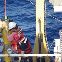
NOAA Mariner Dies When Survey Launch Capsizes
Eric Koss of Woodinville, Wash., was killed August 13 when the hydrographic survey launch he was piloting in Prince William Sound, Alaska, capsized after being struck by high waves, the National Oceanic and Atmospheric Administration (NOAA) said today. NOAA is an agency of the U.S. Department of Commerce. Koss, a member of the crew of the NOAA hydrographic survey ship Rainier, and two other crew members, David Fischman and NOAA Corps Ensign Jennifer Johnson, were in a small launch conducting surveys of the sea bottom off Point Elrington, Elrington Island, in Resurrection Bay. The work had been underway in rough seas, conditions that were normal for that area. The launch was apparently hit by high waves, which turned the boat sideways and capsized it.


