

Derecktor Wins Deal to Build Hybrid RVl for University of Vermont
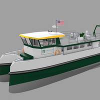
The University of Vermont (UVM) has ordered what is touted as the first hybrid research vessel, a project which brings together Derecktor Shipyards, BAE Systems and Chartwell Marine.The 19-meter catamaran will be designed for low-emission, low-fuel-burn operations and is set for launch in April 2022. Chartwell Marine’s hybrid design, which is powered by two Cummins QSB 6.7m 306hp diesel engines and two BAE AC traction motors, will provide the University with a new research and instruction platform to facilitate its advanced research operation.
Port Security: Autonomous ANTX
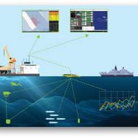
Geophysical seismic surveys and port security may appear to have little in-common. However, it turns out that managing complex marine seismic operations, where 10km-long seismic streamers have to be deployed harmoniously alongside other offshore marine assets, isn’t that dissimilar to managing – and protecting – port facilities.It's an area that ION Geophysical, more known for seismic data acquisition technology, has recently been proving its expertise in, using its Marlin system for marine operations management.
NUWC Division, Newport Signs EPA with New Bedford Whaling Museum
Capt. Michael R. Coughlin, commanding officer of the Naval Undersea Warfare Center (NUWC) Division, Newport, and James Russell, president and chief executive officer (CEO) of the New Bedford Whaling Museum (NBWM), signed an education partnership agreement (EPA) for undersea acoustic research during a brief ceremony on Friday, March 31. Under the EPA, NUWC Newport will provide research, expertise, and material on the Navy's historic and current role in marine mammal research in conjunction with the museum’s recently acquired collection of historic marine mammal recordings, photographs and collection equipment. The William A. Watkins Collection of Marine Mammal Sound Recordings and the William E.
El Faro’s Voyage Data Recorder Recovered
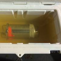
The voyage data recorder (VDR) from El Faro, a U.S. flagged cargo ship that sank during Hurricane Joaquin in October 2015, has been recovered from the ocean floor late Monday evening, the U.S. National Transportation Board (NTSB) said. The recovery of the capsule caps a 10-month-long effort to retrieve the recorder, which was designed to record navigational data and communications between crewmembers on the ship’s bridge. Investigators hope the recorder will reveal information about the final hours of El Faro’s voyage and the circumstances leading up to the sinking.
US Aims to Recover El Faro VDR in Next Few Months
The U.S. National Transportation Safety Board hopes to recover the voyage data recorder from the cargo ship El Faro, which sank during a hurricane killing all 33 crew on board, over the next two to three months, an agency official said on Thursday. A surveillance trip to the site where the ship sank last year, some 15,000 feet (4,600 meters) below sea level off the Bahamas, pinpointed the location of the recorder on April 26. It should contain navigational data and the last 12 hours of audio on the ship's bridge, Brian Curtis, acting director of the Office of Marine Safety at the NTSB, told reporters. He spoke after the voyage to locate the recorder returned to port in Massachusetts. "We know where it is but it is still a tall challenge.
The Hydroptere Flies with Finesse
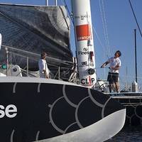
After a year resting in Long Beach, the Hydroptere returns to sailing. French and American sponsors are joined by a new partner: Finesse Solutions of Santa Clara (California), a manufacturer of measurement and control solutions for life sciences process applications. The Hydroptere - called "the flying boat" - is the fastest hydrofoil trimaran in the world, averaging more than 51 knots over 500 meters and exceeding 50 knots over one nautical mile. The crew of Hydroptere intends to set a world speed record across the Pacific Ocean from Los Angeles to Hawaii.
Rosneft to Carry Out Ecologic Fishery Research in Laptev Sea
For the first time in history of Arctic Rosneft will carry out integrated ecologic fishery research on three licensed sites (LS) of Laptev Sea: Anisinsko-Novosibirsky, Ust’ Lensky and Ust’ Oleneksky. The Program of ecologic fishery research realization is the first and obligatory part of licensed sites water areas geologic research, which includes geological and ichthyological surveys. As a result of the research an integrated picture of original (background) ecological state will be received. The field investigations with two vessels will last for 90 days. In this period of time scientists and experts of Murmansk Marine Biological Institute Kola Scientific Center of Russian Academy of Sciences and State Oceanographic Institute named after N.
Historic Great Lakes Shipwreck Possibly Discovered
Steven Libert, president of the Great Lakes Exploration Group, announced he has located what is believed to be the remains of Le Griffon, the first European ship to have sailed the upper Great Lakes. The 45-ton barque carrying seven cannons was built by the legendary French explorer Rene-Robert Cavalier, Sieur de La Salle who was attempting to establish a Northwest Passage through Canada. La Salle wanted to provide a faster way to connect France with its trading partners in the Far East and Le Griffon was to be a vital link in the route between Niagra and Illinois.
Deep Sea UV Implodes in Kermadec Trench
Woods Hole Oceanographic Institute (WHOI) says its deep sea unmanned submersible 'Nereus' has gone missing 10km down while exploring one of the world's deepest spots – the Kermadec Trench, located north east of New Zealand. Surface debris was found, suggesting the vessel suffered a catastrophic implosion as a result of the immense pressures where it was operating. The WHOI apprises that everything was going fine, then the camera feeds abruptly went dark, and the researchers lost communication with the vehicle. Apparently they were not particularly worried: it had happened before and the vehicle designers had planned for something like this.
Coast Guard, Partners Complete Arctic Oil Recovery Exercise
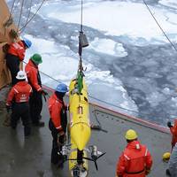
Members of the Coast Guard Research and Development Center, under the guidance of the Coast Guard’s recently released Arctic Strategy, worked with partner federal agencies and scientific organizations to successfully complete a simulated spilled oil response and recovery exercise aboard the Coast Guard Cutter Healy on the Arctic ice field Tuesday. The exercise involved air, surface and underwater assets to simulate the detection and recovery of oil from ice-strewn water. Assets…
Coast Guard to Test Arctic Oil Spill Technologies
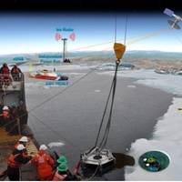
The U.S. Coast Guard Research and Development Center (RDC) plans to test and evaluate oil spill detection and recovery technologies in the Arctic Ocean as part of Operation Arctic Shield 2013. A multi-agency team of engineers and scientists led by RDC researchers will conduct a series of demonstrations in September 2013 aboard Coast Guard Cutter Healy to test and evaluate capabilities of various unmanned aerial systems (UAS), an unmanned underwater vehicle (UUV) and a remotely operated vehicle (ROV) to search for simulated oil spills.
Coast Guard to Test Oil Spill Technologies in Arctic
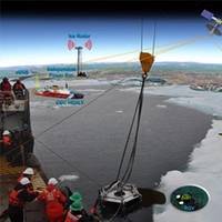
The U.S. Coast Guard Research and Development Center (RDC) plans to test and evaluate oil spill detection and recovery technologies in the Arctic Ocean as part of Operation Arctic Shield 2013. A multi-agency team of engineers and scientists led by RDC researchers will conduct a series of demonstrations in September aboard Coast Guard Cutter Healy to test and evaluate capabilities of various unmanned aerial systems (UAS), an unmanned underwater vehicle (UUV) and a remotely operated vehicle (ROV) to search for simulated oil spills.
PlanetSolar Bound for Boston
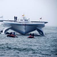
swissnex Boston welcomes "PlanetSolar DeepWater Expedition," June 22-26, 2013. In support of its mission to build stronger relationships between scientists, entrepreneurs and innovators in Massachusetts and Switzerland, swissnex Boston is welcoming the world's largest solar-powered boat to Boston's Fan Pier for its inaugural visit. Together with PlanetSolar and the University of Geneva, swissnex Boston is hosting a series of educational, business and media events about solar technology and climate change…
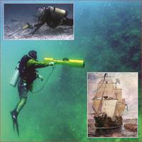
Harold Eugene Doc Edgerton
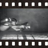
Harold Eugene ‘Doc’ Edgerton was born in Fremont, Nebraska, on April 6, 1903. He was one of three children born to Frank and Mary Edgerton, and from an early age Edgerton like to see what made things tick, spending hours taking things apart and putting them back together. He first became interested in photography through his uncle who was a studio photographer, and his uncle would spend time with the young Edgerton showing him the ins and outs of photography including developing and printing the pictures they took.
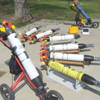
Subsea Robotics: ROV & AUV Market & Tech Trends
The Duke University Center on Globalization, Governance and Competitiveness (CGGC) recently completed a study on ocean technologies, including remotely operated vehicles (ROVs) and autonomous underwater vehicles (AUVs), for a consortium led by Nova Scotia’s Department of Economic and Rural Development and Tourism (ERDT). Excerpts from the report on the market and technology trends in ROVs and AUVs are provided in this article. Global ROV vehicle sales in 2010 totaled approximately $850 million.
NOAA: Air Pollution Plummets when Ships Shift Fuels
New clean fuel regulations in California and voluntary slowdowns by shipping companies substantially reduce air pollution caused by near-shore ships, according to a new NOAA-led study published online today in Environmental Science & Technology. The study examined a container ship operating under a 2009 California regulation requiring that ships switch to low-sulfur fuels as they approach the California coast, and also adhering to a voluntary state slowdown policy, intended to reduce pollution. The research team found that emissions of several health-damaging pollutants, including sulfur dioxide and particulate matter, dropped by as much as 90 percent.
Ambitious Students Participate in "Project Shiphunt"
Sony and Intel’s Project Shiphunt team of young explorers, scientists and historians has returned to shore with news of its underwater discovery: shipwrecks of the schooner M.F. Merrick and the steel freighter Etruria, in deep water off of Presque Isle in Lake Huron. The project was completed with “much thanks to pings, processing and 3D,” according to one marine archaeologist. Current Media, the Peabody-and Emmy Award-winning independent television and online network founded in 2005, will air their adventure as the hour-long special, “Project Shiphunt,” on August 30th at 10 p.m. ET.
Wrecks of the World II, June 6-7
the World: Evaluating and Addressing Potential Underwater Threats” (WOW) II” on Monday, June 6 and Tuesday, June 7, 2011 at the Maritime Institute of Technology and Graduate Studies (MITAGS) in the Washington, DC area (Linthicum Heights, MD) USA. The conference will explore the problem of potentially polluting wrecks and recent incidents around the world that have caused government agencies and responsible parties to look proactively at preventing catastrophic oil and other chemical releases from these long-submerged shipwrecks which may contain as much as 20 million tons of oil and other hazardous materials. Sporadic or continuous leakages or potential sudden massive spillages from these wrecks pose a continual risk across the globe.
More Orders for OceanServer Iver2 AUV
OceanServer Technology announced that it has received purchase orders for 12 new Iver2 AUVs from seven different customers during the last two months. Vehicle orders span four different defense related applications with the majority of these vehicles going to overseas customers. Research related vehicles will be delivered to Woods Hole Oceanographic Institute (WHOI), University of Michigan, YSI Environmental and the US Naval Research Laboratory. The University of Michigan will be taking delivery of their third Iver2 AUV…
Passing of Molly Murphy Crowley

Molly Murphy Crowley, 71, of Piedmont, Calif., Crowley Maritime Corporation board member, past Portland, Ore. real estate mogul, philanthropist and competitive amateur golfer died March 21 following an illness surrounded by her family at her Indian Wells, Calif. vacation home. Mrs. Crowley was born Nov. 27, 1938 in Portland to Dorothy and Peter Murphy. She was the third of eight children, and attended grade school at St. Thomas More Catholic School and high school at Holy Child Academy in Portland, and college at Manhattanville College in Purchase, N.Y.
USACE Deploys Data Buoy Off R.I. Coast
The U.S. Army Corps of Engineers (USACE), New England District, and the Rhode Island Coastal Resources Management Council (CRMC) have partnered to perform an extensive study of the shoreline in southern Rhode Island. This study, known as the Rhode Island Regional Sediment Management (RSM) Plan, is a multi-year program focused on developing a plan for managing sand as a resource rather than as a waste product. The foundation of this study is numerical modeling which is highly dependent on site specific wave data. As part of this study, a significant level of data collection, surveying and numerical modeling will be performed. Currently deployed wave buoys do not provide the wave data that is necessary to conduct this study.
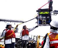
Harbor Branch Gets $2m Navy Grant
Harbor Branch Oceanographic Institute received a $2m grant from the U.S. Navy to develop a robotic laser system to identify mines and other threats in ports and coastal waters. The system to be developed at Harbor Branch would involve a group of underwater robots scanning the water with laser beams and sending information to shore or to a ship above. According to project leader Fraser Dalgleish, an assistant research professor at Harbor Branch, the technology would allow images of much larger areas of the ocean than are now possible.
High-Tech Survey of Rare Deep Coral Reefs
The Waitt Institute for Discovery and Woods Hole Oceanographic Institution have joined forces to launch the Catalyst Program, making available for the first time a versatile and highly portable deep-sea tool kit and operations team, which can be rapidly deployed anywhere in the world. This unprecedented collaboration features the Waitt Institute's two newly built Hydroid REMUS 6000 Autonomous Underwater Vehicles (AUVs), which can explore depths of up to 6000 meters, or 3.7 miles, below the ocean's surface. These innovative multi-sensor platforms are equipped with high-tech survey instruments capable of recording critical oceanographic data, photo-imaging deep-sea features, and producing detailed sonar maps of the ocean floor.


