

Video: USCG Aids Cargo Ship Taking on Water off Puerto Rico
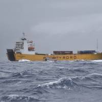
U.S. Coast Guard air and surface rescue crews at Sector San Juan responded and assisted the distressed M/V Island Express Wednesday afternoon, after the ship started taking on water when it departed the Port of San Juan for storm avoidance in anticipation of Tropical Cyclone 9.The M/V Island Express, a Cyprus flagged 412-foot ro-ro cargo ship, and its 18-man crew is now safely moored in San Juan Harbor.Coast Guard watchstanders in Sector San Juan received a Mayday VHF radio transmission on Channel 16 from the Captain of the M/V Island Express…
NOAA Awards $967,000 to 11 Marine Debris Removal Projects
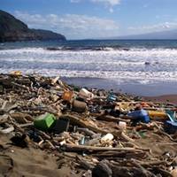
NOAA’s Marine Debris Program provided $967,000 through its Restoration Center to support locally driven, community-based marine debris prevention and removal projects. Eleven groups across the country received funding to remove derelict fishing nets, litter, lumber, tires and other harmful marine debris from shorelines and coastal waters. “Marine debris plagues coastlines all over the country, and these communities have the expertise and motivation to address it,” said Nancy Wallace, Marine Debris Program director.
NOAA’s Newest Chart to Support Puerto Rico Maritime Economy
The Port of San Juan, which is experiencing a tremendous growth of maritime traffic and planning for more, received an additional economic boost today when NOAA debuted a new nautical chart that will make ocean-going vessel traffic safer and more efficient through San Juan Bay and the port area. “There is not only more traffic, but larger vessels are making San Juan their port call,” said Capt. John Lowell, director of NOAA’s Office of Coast Survey. “Mariners asked for NOAA’s help when they started finding themselves too far right of the port entrance,” Lowell said. “The San Juan harbor pilots knew the ship captains were at risk of endangering their vessels.
NOAA’s New Chart Supports Puerto Rico Maritime Economy
The Port of San Juan, which is experiencing a tremendous growth of maritime traffic and planning for more, received an additional economic boost today when NOAA debuted a new nautical chart that will make ocean-going vessel traffic safer and more efficient through San Juan Bay and the port area. “There is not only more traffic, but larger vessels are making San Juan their port call,” said Capt. John Lowell, director of NOAA’s Office of Coast Survey. “Mariners asked for NOAA’s help when they started finding themselves too far right of the port entrance,” Lowell said.


