

UKHO Names Armour Director of Customer Division

The UK Hydrographic Office (UKHO) has announced the appointment of Cathrine Armour as the new Director of its Customer Division.Armour brings experience in leading data, science and technology-centric organizations, and will be instrumental in developing the UKHO as a leading marine geospatial information agency and hydrographic office.Armour joins the UKHO from Catapult’s South West Center of Excellence in Satellite Applications, a partnership led by the University of Exeter to stimulate the data economy; helping UK businesses develop new products and solutions using satellite technology.
EMEC Metocean Data to Stimulate Inovation
The European Marine Energy Centre (EMEC) has provided a series of metocean data sets to be used in a new Scottish open innovation competition aiming to stimulate creative thinking and data science to design new data products for the benefit of the marine environment, communities and economy.Organized by Highlands and Islands Enterprise (HIE) and the Data Lab, Scotland’s Blue Growth Data Challenge will make available data sets from 2015 in-situ observations and numerical modelling from EMEC’s wave and tidal energy test facilities in Orkney.The data sets include wave conditions at EMEC’s Billia Croo wave test site; meteorological observations in two locations adjacent to EMEC’s wave and tidal test sites…
Satellites to Track Illegal 'Pirate Fishing'
Run by the British technology firm Satellite Applications Catapult and backed by the Pew Charitable Trusts, project 'Eyes on the Seas' will open a "Virtual Watch Room". Computers will be able to watch satellite feeds of the waters around Easter Island, a Chilean territory in the southeastern Pacific Ocean, and the western Pacific island nation of Palau, which lacks the resources to monitor all the illegal fishing taking place near its waters. The project is now live and capable of monitoring waters across the world's oceans.
New Satellite System to Track Illegal "Pirate Fishing"
Run by the British technology firm Satellite Applications Catapult and backed by environmental groups, Project 'Eyes on the Sea' will open a "Virtual War Room". Experts will be able to watch satellite feeds of the waters around Easter Island, a Chilean territory in the southeastern Pacific Ocean, and the western Pacific island nation of Palau, which lacks the resources to monitor all the illegal fishing taking place near its waters. The technology analyses numerous sources of live satellite tracking data, enabling monitors to link to information about a ship's country of registration and ownership history to spot suspicious vessels.
Satellite Service Alliance Between Inmarsat & Cisco
Global Xpress (GX) video & multi-media content to be delivered by alliance of Inmarsat and Cisco. Cisco will provide Inmarsat with a state-of-the-art satellite applications service delivery platform and a high-performance access network for GX, its new superfast global broadband system launching in 2014. The world leader in networking solutions, Cisco will also develop a router for end-users that give them access to both the BGAN network and Global Xpress. Cisco will build and operate the network on a fully managed basis before transferring it to Inmarsat. This GX/BGAN integrated platform will allow Inmarsat and its partners to rapidly develop and remotely deploy innovative applications, and it will also extend the reach of new services across the entire Inmarsat network.
UNOSAT 3D Map of Piracy in Gulf of Aden
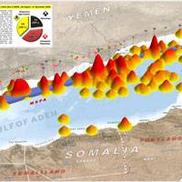
UNOSAT, the UN Institute for Training and Research (UNITAR) Operational Satellite Applications Program, released a 3D map of piracy incidents in the Gulf of Aden for 2008. This 3D perspective map illustrates the relative spatial density of reported pirate incidents in the Gulf of Aden for 2008, current as of 21 November. Incidents that have occurred within 5km of the Maritime Security Patrol Area (MSPA) following implementation on 26 August 2008 are identified. A spatial analysis of the pattern changes in attacks has also been conducted.


