

BOEM and NOAA Release North Atlantic Right Whale and Offshore Wind Strategy
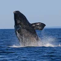
The US Bureau of Ocean Energy Management (BOEM) and the National Oceanic and Atmospheric Administration (NOAA) Fisheries have released a final joint strategy to protect and promote the recovery of endangered North Atlantic right whales while responsibly developing offshore wind energy.The strategy builds on existing mitigation measures to protect North Atlantic right whales from the potential impacts of offshore wind development and was developed to support the Biden-Harris administration's goal of deploying 30GW of offshore wind by 2030.North Atlantic right whales are approaching extinction.
UAF’s GINA Provides a Guiding Hand in Arctic Ocean Research
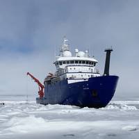
The research vessel Sikuliaq navigated among and around the chunks and slabs of Arctic sea ice above Alaska for several weeks on two voyages this fall, breaking through frozen slabs when it had to, just as its sturdy hull is designed to do. It's now on a third trip.The Sikuliaq, a 261-ft. ice-capable research vessel operated by UAF, pauses in the Arctic Ocean in June 2021 during its fifth year of operation. A few months later, it traveled farther north than ever before — almost 500 miles beyond Point Barrow.Satellite imagery produced at the Geographic Information Network of Alaska…
SatCom Firm Narrowed Down Lost Flight MH370 Location
Inmarsat informs that the Prime Minister of Malaysia, Mr Najib Razak, has stated that new analysis of satellite information from Inmarsat, validated by the UK’s Air Accidents Investigation Branch, concluded that MH370 flew along the southern corridor, and that its last position was in the middle of the Indian Ocean, west of Perth. The Prime Minister added: “This is a remote location, far from any possible landing sites. The announcement came after Inmarsat, as an advisor to the UK’s Accident Air Investigation Branch (AAIB)…
Intellian Launches New VSAT Control Software

Intellian launched Aptus, a new graphical interface based PC software for monitoring and control of Intellian VSAT antennas which it says simplifies use and provides antenna operational data. The Aptus PC software is compatible with all Intellian VSAT antennas and can also be used on the 3-Axis TVRO systems. The software is connected via the onboard network, allowing for use with either PC through a simple one-click installation. Straightforward IP connection over the Internet from anywhere in the world and set-up…
Spying Oil Spills from Space
The Australian Maritime Safety Authority (AMSA) is trialing the use of satellites to detect oil spills in Australian waters. Satellite-based Synthetic Aperture Radar (SSAR) can identify potential oil spills directly from orbit. These satellite sensors can monitor day and night, can see through cloud, rain, fog and other weather. It is one of the most effective and reliable ways of spotting oil spills and the ships that cause them. AMSA’s Acting Marine Environment Division General Manager Jamie Storrie said AMSA currently relies on other vessels, airlines or the public to report any oil spill or marine pollution. “By the time a spill is reported, the oil may have already spread to sensitive areas and the chances of catching the polluter are poor,” Mr. Storrie said.


