

New Dry Bulk Commodity Analytics Company Launched
DBX, a new dry bulk commodity analytics firm based in London, officially launched earlier this year having successfully completed Signal Venture’s incubation program, and it has now initiated a round of seed funding.The venture started in the summer of 2020 with all around support from Signal Ocean. This support included financial, data, technology and recruitment, OilX, an oil commodity analytics firm previously launched by Signal, also provided high level technical support.DBX…
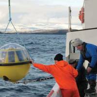
Maersk Vessels Transmit Live Weather Data to Meteorologists
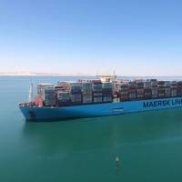
Container shipping giant A.P. Moller - Maersk said it has teamed up with National Meteorological Service of Germany, Deutscher Wetterdienst (DWD) to install automated weather stations enabling a portion of its fleet to transmit live data to help forecast weather and climate.In the largest project of its kind, A.P. Moller - Maersk (Maersk) has installed automated weather stations (AWS) on 50 of its vessels creating a pulsating oceanic web of weather and climate observations. All collected data is transmitted live to the National Meteorological Service of Germany…
NOAA Launches West Coast, Gulf of Mexico Coastal Models
NOAA on Wednesday announced two new coastal condition forecast models intended to help enhance decision making for mariners along the West Coast and Northern Gulf of Mexico. The models provide continuous quality-controlled data on water levels, currents, water temperature and salinity out to 72 hours.Forecasts from both models are used by commercial and recreational mariners, fisherman, emergency managers, search and rescue responders, and National Weather Service marine weather…
Arctic Sea Ice Lows Mark a New Polar Climate Regime
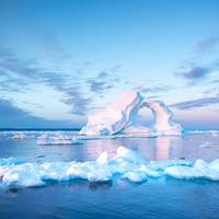
At the edge of the ice blanketing part of the Arctic Ocean, the ice looked sickly. Where thick sheets of ice once sat atop the water, now a layer of soft, spongey slush slid and bobbed atop the waves.From the deck of a research ship under a bright, clear sky, “ice pilot” Paul Ruzycki mused over how quickly the region was changing since he began helping ships spot and navigate between icebergs in 1996.“Not so long ago, I heard that we had 100 years before the Arctic would be ice free in the summer,” he said. “Then I heard 75 years, 25 years, and just recently I heard 15 years.
Tech Talk: Managing Ship Biofouling During Layups due to COVID-19

Biofouling control measures for ships are usually selected to match their operational profiles, and so what happens when constant service ships become idle for prolonged periods or operate at slower service speeds? Will they become vulnerable to fouling, and what measures can be taken to reduce the risk? These questions can best be answered by understanding the biology of the waters in which the vessels are located, the ecology of the different immersed parts of the ship, the biofouling control methods that have been applied or in use…
World Magnetic Model Updated
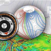
NOAA officials announced today the World Magnetic Model (WMM), a representation of Earth’s large-scale magnetic field and an indispensable complement to GPS devices used by NATO, the United States and United Kingdom militaries, as well as civil applications ranging from mineral exploration to smartphone apps, has been updated. Changes in the Earth's outer core trigger unpredictable changes in its magnetic field, an invisible force that extends from Earth's interior to where it meets a stream of charged particles emanating from the Sun.
Thickness of Antarctic Sea Ice Surpass Expectations
Antarctica's ice paradox has yet another puzzling layer. Not only is the amount of sea ice increasing each year, but an underwater robot now shows the ice is also much thicker than was previously thought, a new study reports. The discovery adds to the ongoing mystery of Antarctica's expanding sea ice. According to climate models, the region's sea ice should be shrinking each year because of global warming. Instead, satellite observations show the ice is expanding, and the continent's sea ice has set new records for the past three winters. At the same time, Antarctica's ice sheet (the glacial ice on land) is melting and retreating. Measuring sea ice thickness is a crucial step in understanding what's driving the growth of sea ice…
NOAA, NASA & BOEM to Monitor Biodiversity
NOAA, NASA and the Department of the Interior's Bureau of Ocean Energy Management (BOEM) have joined together to support three demonstration projects that will lay the foundation for the first national network to monitor marine biodiversity at scales ranging from microbes to whales. The projects, to be funded at approximately $17 million over the next five years, subject to the availability of funds, will demonstrate how a national operational marine biodiversity observation network could be developed. Such a network would serve as a marine resource management tool to conserve existing biodiversity and enhance U.S. biosecurity against threats such as invasive species and infectious agents.
Navy's Global Ocean Forecast System Goes Public
The U.S. Naval Research Laboratory (NRL) & the National Center for Environmental Prediction (NCEP) within the National Ocean and Atmospheric Administration (NOAA) have entered into a formal agreement that results in NCEP using Navy developed global ocean forecast model technology to make environmental ocean forecasts for public use. “Development of an advanced global ocean prediction system has been a long-term Navy interest,” said Dr. Gregg Jacobs, head, NRL Ocean Dynamics and Prediction Branch.
The Arctic: Emerging Maritime Frontier

The Commandant of the United States Coast Guard, Admiral Bob Papp, Jr. spoke of the Arctic as an emerging frontier during the 2013 State of the Coast Guard Address in February 2013. He said, “… one example of what our future holds can be seen in the emerging frontier of the Arctic, where there is a new ocean appearing. In September 2012, we observed the lowest sea ice extent in recorded history, and there are vast areas of open water where there used to be ice…As the receding ice increasingly gives way to commercial ventures…
Muddy Footprints: Satellite's View of Ship Pollution
Long tracks of elevated nitrogen dioxide (NO2) levels show up along certain shipping routes when viewed from NASA's Aura satellite. For more than a decade, scientists have observed “ship tracks” in natural-color satellite imagery of the ocean. These bright, linear trails amidst the cloud layers are created by particles and gases from ships. They are a visible manifestation of pollution from ship exhaust, and scientists can now see that ships have a more subtle, almost invisible, signature as well, according to 'NASA Earth Observatory'.
GOM Sheen Investigation Plan Approved
FOSC for the Deepwater Horizon oil spill in New Orleans approved a joint plan from BP and Transocean. The Federal On-Scene Coordinator for the Deepwater Horizon oil spill in New Orleans approved a joint plan from BP and Transocean Thursday. The joint plan was required by Coast Guard Capt. Duke Walker to identify the source of a sheen located in the Gulf of Mexico that has been associated with Macondo 252 oil. The Notice of Federal Interest informed BP and Transocean that they may be responsible for costs related to identifying the source of the sheen and cleanup. The proposed joint plan includes satellite observations and mobilizing remotely operated vehicles to examine the original Macondo well area including the wreckage, debris, and the riser on the sea floor.
Navy Charts Way Ahead in Arctic
The chief of naval operations created a task force, headed by the Navy's senior oceanographer, to better understand and evaluate the changing climate and its implications for maritime security. "Task Force Climate Change was initiated ... to assess the Navy's preparedness to respond to emerging requirements and to develop a science-based time line for future Navy actions regarding climate change," explained Rear Adm. "Because the Arctic is changing faster than any other place on the planet, our first deliverable will be a strategic roadmap proposing actions for the Navy regarding the Arctic region," Titley said. This may include an assessment of how the maritime strategy applies to the Arctic region…


