

Kongsberg Marine Bags Award for DPS
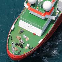
The state-of-the-art DPS i-Series Differential Positioning System has won the ‘Innovative Dredging Technology of the Year’ category at the Dredging and Port Construction Awards 2018.The judges highlighted the unique system as a powerful tool for dredging contractors who can now leverage the same abilities for high-precision applications as offshore operators; using sensor technology combined with satellite positioning systems to improve not just the position of dredging vessels but also their efficiency.Ines Nastali, the editor of Dredging and Port Construction, a tightly focused business and technical journal for the dredging industry celebrating its 50th anniversary this year…
NASA, Norway to Develop Arctic Laser-Ranging Station
NASA and the Norwegian Mapping Authority are partnering to develop a state-of-the-art satellite laser ranging station 650 miles from the North Pole that will produce high-precision locations of orbiting satellites, help track changes in the ice sheets and improve the efficiency of marine transportation and agriculture. The Arctic station will be the latest addition to a global network of space geodetic stations, which measure and monitor the size and shape of Earth, its orientation in space, the exact location of points on its surface and how these locations change over time. Space geodesy has a decades-long history at NASA due to its important role in the positioning and navigation of satellites.
Human Factor Competencies for Future Mariner
Capt Pradeep Chawla, Managing Director QHSE & Training, Anglo-Eastern Ship Management Ltd., Presented a paper at the Nautical Institute Hong Kong Branch Seminar – “Competencies of a Future Mariner” on 23 October 2015. This paper discusses the changes that are taking place in the maritime industry and their effects on the daily life of the seafarers. It further discusses the human factor competencies that will be essential for the future mariner. The last two decades have been extremely fast paced with respect to technology influencing every walk of life. Internet, Google, Facebook, Linkedin, smartphones, WhatsApp etc. and their effects on the way we communicate, interact and learn are well-known.
Fugro Introduces G2+ Positioning Service
Fugro has introduced its high accuracy G2+ service for the GNSS augmentation field, the company announced today. The G2+ service is designed to benefit offshore operators around the globe who require positioning and measurement accuracy at the centimeter level. G2+ is an enhancement of Fugro’s G2 service (based on GPS and GLONASS) and utilizes highly advanced GNSS augmentation algorithms developed in-house. The code and carrier-phase signals transmitted by GPS and GLONASS satellites are monitored globally by Fugro’s worldwide network of reference stations. These observations are processed centrally in real-time using the company’s proprietary algorithms to generate precise corrections which are used to augment the standard signals broadcast by GPS and GLONASS satellites.
Fugro Launches Seastar XP2
Fugro Satellite Positioning released its Seastar XP2 PPP GNSS augmentation service on July 1, 2014, which provides increased redundancy for mission-critical offshore GNSS position and navigation applications. Like Fugro’s flagship Seastar G2 service, XP2 is an L1/L2, phase-based, Orbit and Clock PPP service. Similar to the 24+ American GPS satellites, XP2 incorporates a number of Russian GLONASS satellites to generate corrections that permit the calculation of a real-time position solution. The new XP2 service mimics Fugro’s flagship G2 and offers accuracies approaching it.
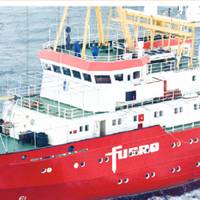
Dutch Survey Vessel Joins Search for MH370
Dutch engineers this week started a months-long survey to map unchartered deep-sea terrain at the bottom of the Indian Ocean, the next step in the search for the wreck of Malaysian Airlines flight MH370, a company official told Reuters. A survey ship from Dutch engineering company Fugro , carrying 40 crew and technicians, began mapping out an area larger than the Netherlands, some 1000 miles (1,600 km) east of the northwest coast of Australia. The search for the lost plane is…
Fugro Awarded Five-Year Positioning Contract by DOF ASA
Fugro has won a contract from DOF ASA for the provision of precise satellite positioning for the entire DOF fleet of more than 70 vessels globally. The contract is valid for a firm five years with two optional years and also includes the new vessels in DOF’s continuously expanding fleet. DOF an owner and operator of purpose-built vessels providing services to the offshore energy sector across the entire offshore lifecycle. Fugro, a provider of precise satellite positioning to the offshore oil and gas industry, will provide three completely independent high precision differential Global Navigation Satellite Systems to DOF. In addition DOF’s subsea vessels will be equipped with state-of-the-art hardware and software developed by Fugro, providing a truly independent solution for each vessel.
Kongsberg Launches Laser-based Reference System
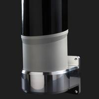
Kongsberg Seatex launched SpotTrack, a multi-target laser based relative position reference system. SpotTrack delivers accurate range and bearing measurements and is primarily intended for Dynamic Positioning (DP) operations. Kongsberg Describes SpotTrack as a robust, lightweight, motion stabilized rotating laser sensor offering precision range and bearing readings to one or multiple retro-reflective targets. As a multi-target sensor, SpotTrack uses an advanced detection system and tracking algorithms for true target recognition – minimizing lock-on to false reflections.
Applied Weather Technology Appoint New CEO

Ship routing advisory services & onboard voyage optimization systems provider Applied Weather Technology, Inc. (AWT) has appointed Haydn Jones as Chief Executive Officer. From AWT's headquarters in the Silicon Valley, Jones will lead AWT's 10 offices to deliver industry leading products and services to the company's 800 shipping clients. Most recently, Jones served as AWT's director of international operations, overseeing sales, marketing and business development. He is also a member of the parent company board of directors.
AWT Appoints New CEO Haydn Jones

Seasoned Maritime Executive Has Deep Industry Experience and Strong Focus on Ship Efficiency Systems. Applied Weather Technology, Inc. (AWT) appointed Haydn Jones as Chief Executive Officer. From AWT’s headquarters in the Silicon Valley, Jones will lead AWT’s 10 offices to deliver industry leading products and services to the company’s 800 shipping clients. Most recently, Jones served as AWT’s director of international operations, overseeing sales, marketing and business development. He is also a member of the parent company board of directors.
Fugro Take Delivery of New Offshore Survey Vessel
Fugro's new offshore survey coastal vessel, 'R.V. Fugro Helmert', is the latest in Fugro's fleet renewal programme. Built to Fugro's specifications for a highly manoeuvrable, versatile survey vessel, Fugro Helmert is intended to enable the group to better respond to the survey needs of offshore wind energy projects, offshore cable and pipeline corridor design and nautical hydrographic charting programmes to aid safe navigation. The 41.5 metre-long vessel has dynamic position station-holding capability (DP1) and is equipped with a sophisticated suite of modern handling and surveying systems…
Container Tracking System Installation Up 54 Percent in 2012
According to a new research report from the analyst firm Berg Insight, the number of active remote container tracking units deployed on intermodal shipping containers was 137,000 in Q4-2012, up from 89,000 a year earlier. Growing at a compound annual growth rate (CAGR) of 49.1%, this number is expected to reach 1 million by 2017. The penetration rate of remote tracking systems in the total population of containers is estimated to increase from 0.7% in 2012 to 4.1% in 2017. Berg Insight’s definition of a real-time container tracking solution is a system that incorporates data logging, satellite positioning and data communication to a back-office application. The market for container tracking solutions is still in its early stage.
Haydn Jones Tapped to lead AWT International Ops

Experienced Marine Industry Executive to Lead Worldwide Management of Sales, Marketing, Strategic Business Development and Channel Partnerships. Applied Weather Technology, Inc. (AWT), is pleased to announce the appointment of Haydn Jones as the company's Director of International Operations. In this role Jones will be responsible for sales, marketing and business development of the company's range of maritime ship routing services and onboard system, in addition to overseeing the international support organization. Jones will be a member of the parent company board of directors.
GNSS Guidelines Update
After an extensive review and update, the former UKOOA document “Guidelines for the use of GPS in offshore surveying” has been jointly issued as a new document by theInternational Association of Oil & Gas Producers (OGP) and the International Marine Contractors Association (IMCA). The document was reviewed by a workgroup comprising representatives of OGP’s Geomatics Committee and IMCA’s Offshore Survey Division Management Committee, as well as representatives from the marine survey industry. The use of satellite positioning is critical to the success of a wide variety of oil and gas related surveying and positioning projects. The “Guidelines…
New Sources of Finance Needed for EU Transport Infrastructure
The Transport Committee believes that continued financial inaction on the transport infrastructure may put economic growth at risk. In a report adopted, it calls on the Commission to table proposals on possible new and alternative ways of financing, in particular, the Trans-European Transport Networks (TEN-T). Since the priority investments have been slower than expected, key projects should now be selected for their financial feasibility. In Etelka Barsy-Partaki's (EPP-ED, HU) own-initiative report on the mid-term review of the Commission's 2001 Transport White Paper, there was general support for the Commission's stance, but MEPs in…
Coast Guard Locates Capsized Vessel with EPIRB
The U.S. Coast Guard and the Canadian Coast Guard responded to a mayday call at 7:40 p.m. that was sent out by a 406-megahertz EPIRB or Emergency Position Indicating Radio Beacon. The signal was positioned 3 Nautical Miles S.W. of Race Rocks in Canadian waters. The EPIRB allowed rescue personnel to quickly locate the capsized trimeran, the "Red Shift" and her crew of four. A Coast Guard HH-65A Dolphin helicopter from Air Station Port Angeles and the Coast Guard Cutter Osprey were dispatched to respond to the mayday signal of the EPIRB. The Coast Guard helicopter arrived on scene to find three of the crew sitting on the capsized vessel with a fourth trapped inside. The rescue swimmer was lowered from the helicopter into the water. He then assisted the trapped man from the cabin.


