

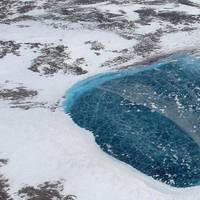
Arctic and Antarctic Sea Ice Reach Minimum Extent for 2023
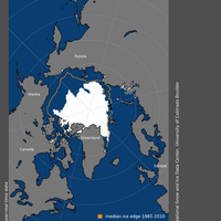
Arctic sea ice likely reached its minimum extent for the year at 4.23 million square kilometers (1.63 million square miles) on September 19, 2023, according to scientists at the National Snow and Ice Data Center (NSIDC) at the University of Colorado Boulder.The 2023 minimum is ranked sixth lowest in the nearly 45-year satellite record. The last 17 annual minimum extents are the lowest 17 in the satellite record.NSIDC scientists stress that the Arctic sea ice extent number is preliminary…
IPCC SROCC Reports Call for HFO Ban
The Clean Arctic Alliance and the Inuit Circumpolar Council Canada call for urgent action to ban heavy fuel oil (HFO) use and carriage by Arctic shipping to reduce risks of a devastating spill, and to reduce black carbon emissions in the Arctic, responding to Intergovernmental Panel on Climate Change (IPCC) Special Report on the Ocean and Cryosphere in a Changing Climate (SROCC).SROCC’s Summary for Policymakers states that “Arctic ship-based transportation and tourism have implications for global trade, northern nations, and economies linked to traditional shipping corridors; they will also exacerbate local risks to marine ecosystems…
A Record-Low Start to Ice the New Year in Antarctica
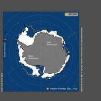
As of January 1, 2019, Antarctic sea ice extent had experienced several days of record lows. These record-low extents, which followed a period of rapid ice loss in December, exemplify the high seasonal and year-to-year variability in Antarctic sea ice. With six to eight weeks remaining in the melt season, it remains to be seen whether the present situation will persist and lead to a record-low annual minimum. A discussion of Arctic conditions will be posted next week.Overview of conditionsOn January 1…
Arctic Ice Sets New Record Low for Winter
The extent of sea ice in the Arctic Ocean has set a new record low for the wintertime in a region strongly affected by long-term trends of global warming, U.S. and European scientists said on Wednesday. Sea ice around the North Pole expands to its biggest extent of the year in February or March after a deep freeze in the winter polar darkness and shrinks to the smallest of the year in September, at the end of the brief Arctic summer. Arctic sea ice appears to have reached its annual maximum extent on March 7…
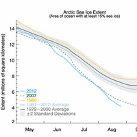
Arctic Sea Ice Melt Continues
As of August 14, Arctic sea ice extent is tracking third lowest in the satellite record, according to the National Snow & Ice Data Center (NSIDC). The southern route through the Northwest Passage appears to be largely free of ice. Despite a rather diffuse ice cover in the Chukchi Sea, it is unlikely that Arctic sea ice extent this September will fall below the record minimum set in 2012. As of August 14, Arctic sea ice extent was 5.61 million square kilometers, the third lowest extent in the satellite record for this date and slightly below the two standard deviation range.
Arctic Sea Ice Melt at Higher Level
Sea ice is decreasing in the Arctic but year-to-year variability in sea ice extent is large. Ice extent is influenced by atmospheric circulation, with temperatures dictating ice melt, and winds shifting the ice, reports the Nature. According to National Snow and Ice Data Center, through the first half of July, Arctic sea ice extent continued tracking close to levels in 2012, the summer that ended with the lowest September extent in the satellite record. The stormy weather pattern that characterized June has persisted into July. Nevertheless, sea ice melt began earlier than average over most of the Arctic Ocean. As of July 18, Arctic sea ice extent was 7.82 million square kilometers (3.02 million square miles).
Arctic Sea Ice at Alrmingly Lower Level
Low Arctic sea ice extent for March caps a highly unusual winter in the Arctic, says the US National Snow and Ice Data Centre (NSIDC). In March, Arctic sea ice extent fell to its second lowest extent since 1981 — as did the overall Arctic sea ice extent for 2106. The decline of Arctic sea ice is already setting records in 2016, with the winter peak in March clocking in as the lowest since satellite records began, scientists say. Low Arctic sea ice extent for March caps a highly unusual winter in the Arctic, characterized by persistent warmth in the atmosphere that helped to limit ice growth. Above-average influx of ocean heat from the Atlantic and southerly winds helped to keep ice extent especially low in the Barents and Kara seas.
Arctic Sea Ice Sets Record Low Extent at Winter Maximum
Arctic sea ice has set a new winter record by freezing over the smallest extent since satellite records began in 1979, in a new sign of long-term climate change, U.S. data showed on Thursday. The ice floating on the Arctic Ocean around the North Pole reached its maximum annual extent of just 14.54 million square kms (5.61 million sq miles) on Feb. 25 - slightly bigger than Canada - and is now expected to shrink with a spring thaw. "This year's maximum ice extent was the lowest in the satellite record…
Bering Sea Early Sea Ice Break-Up 2014
The National Snow & Ice Data Center informs that since reaching its annual maximum extent on March 21, Arctic sea ice extent has declined somewhat unevenly, but has consistently been well below its average 1981 to 2010 extent. While the rate of Arctic-wide retreat was rapid through the first half of April, it has subsequently slowed down. However, ice breakup was quite early in the Bering Sea, presenting difficulties for gold dredging operations and seal hunters in the region. In the Antarctic, sea ice continued to reach record high extents. Average ice extent for April 2014 was the fifth lowest for the month in the satellite record. Through 2014, the linear rate of decline for April ice extent is -2.4% per decade relative to the 1981 to 2010 average.
Arctic Sea Ice Reaches Maximum Extent for 2014
NSIDC issued an update to Arctic Sea Ice News & Analysis describing winter sea ice conditions in the Arctic Ocean stating Arctic sea ice reached its maximum extent for the year on March 21 at 14.91 million square kilometers (5.76 million square miles), making it the fifth lowest maximum in the satellite record (1978-2014). Antarctic sea ice reached its annual minimum on February 23, and was the fourth highest Antarctic minimum in the satellite record. While this continues a strong pattern of greater-than-average sea ice extent in Antarctica for the past two years…
Arctic Ice Melt Has Begun
NOAA Environmental Visualization Lab reports ice now shrinking. After reaching its maximum extent for the year on March 15, 2013, the average extent of sea ice in the Arctic has begun shrinking and will probably reach its minimum extent sometime in mid-September. This year’s maximum extent was the sixth lowest in the satellite record, according to the National Snow and Ice Data Center. At 15.13 million square kilometers, the maximum extent was 733,000 square kilometers below the 1979 to 2000 average of 15.86 million square kilometers…
Northern Sea Route Partly Blocked Although Sea Ice Near Minimum
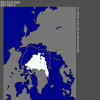
So far this year only the southern passage has opened despite record low levels of Arctic sea ice. According to the National Snow and Ice Data Center, the current extent is 760,000 square kilometers (293,000 square miles) below the previous record minimum extent in the satellite record (4.17 million square kilometers or 1.61 million square miles) which occurred on September 18, 2007. This difference is larger than the size of the state of Texas. The ice extent currently tracks nearly 50% below the 1979 to 2000 average minimum extent.
Arctic Sea Ice Lowest in Satellite Era
National Snow & Ice Data Center reports ice appears to have broken the 2007 record daily extent. With two to three more weeks left in the melt season, sea ice continues to track below 2007 daily extents. Arctic sea ice extent fell to 4.10 million square kilometers (1.58 million square miles) on August 26, 2012. This was 70,000 square kilometers (27,000 square miles) below the September 18, 2007 daily extent of 4.17 million square kilometers (1.61 million square miles). Including this year, the six lowest ice extents in the satellite record have occurred in the last six years (2007 to 2012).


