

Hepburn and Sons Adds Senior Naval Talent

The Hepburn and Sons LLC team welcomed David Rice, CAPT David Bauer, USN (Ret), and Gary Loberg as their newest members. David Rice serves as Senior Consultant, Material Science. David Bauer will serve as the Senior Manager, Material Science. Gary Loberg serves as Senior Manager, Advisory Services.David Rice comes to Hepburn and Sons, LLC after a career spanning 45 years at Newport News Shipbuilding (NNS). During his time at NNS he served as the Manager of Contracted Research & Development and was responsible for Research & Development Programs funded by ONR/ManTech…
Latest Innovations in Heavy Duty Machinery
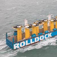
In the first of a series of marine industry sector reviews, MR&EN correspondent Tom Mulligan reports on the latest innovations in heavy lifting machinery technology with a selective overview of new product launches and recent equipment installations on board ships, ferries and workboats, as well as in ports, docks, harbors and shipping terminals worldwide. Markey Machinery’s Render/Recover and Asymmetric Render/Recover ‘active heave’ compensating winches have been recognized as…
Willard to Build 3 Survey Ships for NOAA
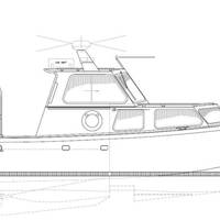
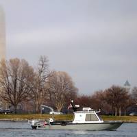
Willard Marine informs it was awarded a contract to provide the National Oceanic and Atmospheric Administration (NOAA) with three aluminum hydrographic survey launch ships (HSLs). The three 28-foot HSLs will be used to conduct oceanographic surveys with hull-mounted and towed sonar units in U.S. coastal waters. A Cummins QSC8.3 engine capable of 510 HP with a ZF Marine 305-2 transmission will be used to power the boats. Outfitted to support traditional manned survey operations, the HSLs will offer additional flexibility to add unmanned autonomous capability.
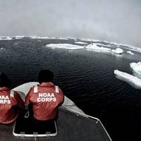
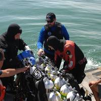
NOAA Deploys Survey Ships for Arctic Charting Projects
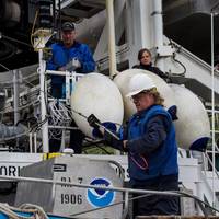
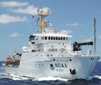
NOAA announced the official launch of its 2015 Arctic hydrographic survey season took place this morning, in Kodiak, Alaska, in a World Ocean Day ceremony which showcased the deployment of the NOAA ships Rainier and Fairweather. “Most Arctic waters that are charted were surveyed with obsolete technology, with some of the information dating back to Captain Cook's voyages, long before the region was part of the United States,” said NOAA deputy under secretary for operations Vice Admiral Michael S. Devany in remarks directed to the crews of NOAA ships.
Boaterz n Bikerz Hull of a Tour Launches Freedom Ride
The Boaterz ‘n Bikerz Hull of a Tour² launch of “The Freedom Ride” throttled forward yesterday from Freedom Boat Club’s Marina Jack location in downtown Sarasota, FL. The nine-day, 2000-mile motorcycle and boating tour attracted 30 members of the boating industry including their friends, and travels up the east coast to Washington D.C., concluding with participation in the 100,000-bike rally, Rolling Thunder, which honors war veterans, POWs and MIA on Memorial Day weekend. “This ride is a celebration of freedom and the great outdoors,” said tour organizer and marine industry marketing veteran Wanda Kenton Smith. “Our tour is unique in that we combine the best of the open roads with the open seas in an adventure that promotes both motorcycling and boating activity.
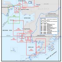
NOAA to Boost Arctic Nautical Charting
NOAA plans increased 2015 Arctic nautical charting operations, coordinating with U.S. As commercial shipping traffic increases in the Arctic, NOAA informs it is taking steps to update nautical charts in the region. NOAA’s Office of Coast Survey will use data collected by two of its own ships, Rainier and Fairweather, as well as the U.S. Coast Guard cutter Healy and a private sector hydrographic contractor to cover nearly 12,000 nautical miles in the Arctic for use in updating its navigational charts.
NOAA Orders Newbuild Navigation Response Boats
NOAA today announced that Lake Assault Boats of Superior, Wisconsin, will build two small vessels for the Office of Coast Survey's navigation response program, part of a plan to eventually replace all six of the program's small survey boats. The combined cost of both 28-foot vessels is $538,200. "All of the navigation response team survey boats are nearing or have exceeded their designed service life," said Russ Proctor, division chief of Coast Survey's Navigation Services Division.
NOAA Begins Hydrographic Survey Season
New data will update nautical charts around the country. As sure as spring arrives, NOAA vessels and independent contractors are hitting the seas for the nation's 180th hydrographic surveying season, collecting data for over two thousand square nautical miles in high-traffic U.S. coastal waters. "Nautical charts are the foundation for the nation's maritime economy, and NOAA hydrographers spend months at sea, surveying critical areas to ensure safe navigation for the shipping, fishing, and boating communities," said Rear Admiral Gerd Glang, director of the Office of Coast Survey.
NOAA Certifies More Printing Agents
The availability of paper "print-on-demand" nautical charts continues to expand, as NOAA's Office of Coast Survey has added three more printing companies to its roster of certified agents for paper charts. "The most recent printers to join the NOAA paper chart program represent the enduring connections between maritime tradition and progress," said Capt. Shep Smith, chief of Coast Survey's Marine Chart Division. "Companies with histories going back decades, and even centuries, support a firm foundation for the continuing production and delivery of U.S. Iver C. Weilbach & Co.
Walker Wreck Added to Historic Places Register
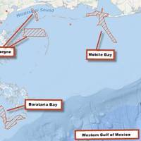
NOAA announced that the wreck of the ship USCS Robert J. Walker, a steamer that served in the U.S. Coast Survey, a predecessor agency of NOAA’s Office of Coast Survey, has been added to the National Register of Historic Places. The Walker served as survey ship, charting the Gulf Coast ‒ including Mobile Bay and the Florida Keys ‒ in the decade before the Civil War. It also conducted early work plotting the movement of the Gulf Stream along the Atlantic Coast. Twenty-one men died when Walker sank in rough seas in the early morning hours of June 21…
NOAA Nautical Charts Now Permanently Free

After a three-month trial period, PDF versions of NOAA nautical charts will become a permanent product, free to the public. The free PDFs, which are digital images of traditional nautical charts, are especially valued by recreational boaters who use them to plan sailing routes and fishing trips. The free PDF charts are part of a suite of new and enhanced navigational products designed to make NOAA’s data more accessible to the general public. “Up to date charts help boaters avoid groundings and other dangers to navigation…
NOAA Finds Lost 19th Century U.S. Coast Survey Steamer

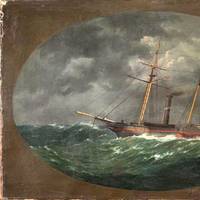
More than 153 years after it was lost in a violent collision at sea, government and university maritime archaeologists have identified the wreck of the ship Robert J. Walker, a steamer that served in the U.S. Coast Survey, a predecessor agency of NOAA. The Walker, while now largely forgotten, served a vital role as a survey ship, charting the Gulf Coast ‒ including Mobile Bay and the Florida Keys ‒ in the decade before the Civil War. It also conducted early work plotting the movement of the Gulf Stream along the Atlantic Coast.
Subsea Wreck Identifed Off NJ Coast 153 Years On
Lost after a violent collision at sea, government and university maritime archaeologists have identified the wreck of the ship 'Robert J. Walker', a steamer that served in the U.S. Coast Survey, a predecessor agency of NOAA. Twenty sailors died when the Walker sank in rough seas in the early morning hours of June 21, 1860, ten miles off Absecon Inlet on the New Jersey coast. The crew had finished its latest surveys in the Gulf of Mexico and was sailing to New York when the Walker was hit by a commercial schooner off New Jersey.
NOAA’s Coast Survey Plans for New Arctic Nautical Charts
Less sea ice and more ship traffic means new charts needed for safety. NOAA’s Office of Coast Survey has issued an updated Arctic Nautical Charting Plan, as a major effort to improve inadequate chart coverage for Arctic areas experiencing increasing vessel traffic due to ice diminishment. The update came after consultations with maritime interests and the public, as well as with other federal, state, and local agencies. “As multi-year sea ice continues to disappear, vessel traffic in the Arctic is on the rise,” said Rear Admiral Gerd Glang, NOAA Coast Survey director.
NOAA and U.S. Power Squadrons Renew Program
This week, NOAA and the U.S. Power Squadrons, a non-profit organization dedicated to safe boating, will renew a 50-year commitment to a cooperative charting program that helps to update the nation's thousands of navigational charts. Under the voluntary program, formalized by a Memorandum of Agreement, members of the U.S. Power Squadrons scan water and land areas, looking for changing conditions that may not be reflected on NOAA nautical charts. Power Squadrons members submit their reports online, and NOAA cartographers review and incorporate changes to their navigation products. "The partnership between Coast Survey and the Power Squadrons is a long and successful one, speaking to our shared vision of safety on U.S.
NOAA Ship 'Thomas Jefferson' Returns
The NOAA Ship Thomas Jefferson wraps up an exceptionally eventful field season. After 193 days away from home, the hydrographic survey vessel completed 14, 768.9 linear nautical miles of survey that covered 352 square nautical miles of area in Long Island Sound and Block Island Sound. Due to this work, 38 dangers to navigation (DTONs) were issued, protecting maritime traffic in the area. Additionally, the Thomas Jefferson was in prime position to respond to the devastation caused by Hurricane Sandy in October and November. The U.S.
Superstorm 'Sandy' Navigational Update from NOAA
Restoring fuel flow into the New York area a top priority, but barge deliveries hampered by obstructions. NOAA Ship Thomas Jefferson mobilized through the night to New York Harbor where they began surveying at 3:12 a.m. 1, November, looking for the sunken containers, debris, and shoaling that pose dangers to ships and lives. In the darkness, using high tech side scan sonar equipment, Thomas Jefferson conducted the hydrographic survey of the designated areas on the Hudson River. With the information provided by the Thomas Jefferson's survey, the U.S.
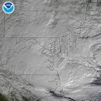
NOAA Prepares Hurricane 'Sandy' Maritime Response
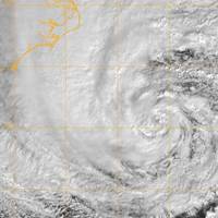
Hurricane-force winds are expected along portions of the coast between Chincoteague Virginia and Chatham Massachusetts. As Hurricane 'Sandy' heads north along the Atlantic coast, NOAA’s Office of Coast Survey is deep into preparations for maritime rapid response. Two objectives stand out: move navigation response personnel and assets into position to move quickly once SANDY moves out; and batten down survey vessels, to protect them from storm damage. Coast Survey regularly responds to requests for quick navigation surveys after storms and other damaging events…
NOAA Seafloor Mapping Project Delivers Diverse Data
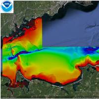
NOAA ship 'Thomas Jefferson' mapping Long Island Sound seafloor this summer contributes to a multi-level data gathering collaboration. In addition to updating NOAA’s nautical charts, ongoing collaborations in Long Island Sound will create products that depict physical, geological, ecological, geomorphological, and biological conditions and processes – all to balance the development of new ocean uses while protecting and restoring essential habitats. In 2011, the Long Island Sound Program (representing a partnership between the State of Connecticut…
"The Future of Our Oceans"

On April 23, 2012, Dr. Stephen M. Coan delivered remarks entitled “The Future of Our Ocean”, part of the Open VISIONS Forum Lecture Series and presented at the Regina A. Quick Center for the Arts, Fairfield University, Fairfield, Conn. Following is the text of his speech. Water sustains life on Earth, and the health of our oceans, lakes, rivers, streams and marshlands, which cover 70% of the planet’s surface, is critically important to global economic and human health. Imagine this vast environment and what it could mean for us if we were able to better harvest food…
Seafarer Heroism Honored at AOTOS Event
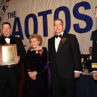
Five separate episodes of heroism and bravery on the high seas were recognized at the 42nd annual United Seamen's Service Admiral of the Ocean Sea (AOTOS) dinner. The AOTOS event itself honored James L. Henry, Chairman and President of the Transportation Institute; General Duncan J. McNabb, USAF, former Commander, U.S. Transportation Command; and Robert D. Somerville, Chairman of ABS (formerly the American Bureau of Shipping). The maritime industry's most prestigious awards since…
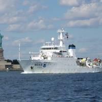
NOAA Ship Rainier Returns to Alaska for Sea Floor Surveys
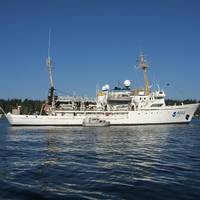
NOAA Ship Rainier returns to Alaska to conduct sea floor surveys in support of safe navigation. NOAA Ship Rainier has begun a month long survey of the sea floor near Alaska’s Prince of Wales Island as part of a multi-year effort to update nautical charts for the area. In addition to supporting marine navigation, data acquired by the 231-foot hydrographic survey vessel will also support marine ecosystem studies and improve inundation models for areas vulnerable to tsunamis. “We are pleased to return to Alaska to continue these important surveys…
NOAA's Thomas Jefferson Conducting Surveys
NOAA Ship Thomas Jefferson conducts sea floor surveys to keep shipping safe along Long Island coast. NOAA Ship Thomas Jefferson continues today on a three-month survey of the sea floor off the coast of New York, Connecticut and Rhode Island, as part of a multi-year effort to update nautical charts for Block Island Sound and keep large ships and commerce moving safely. In addition to supporting marine navigation, data acquired by the 208-foot hydrographic survey vessel will also support a seafloor mapping initiative by Connecticut and New York.


