

Walker Wreck Added to Historic Places Register
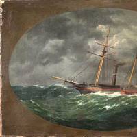
NOAA announced that the wreck of the ship USCS Robert J. Walker, a steamer that served in the U.S. Coast Survey, a predecessor agency of NOAA’s Office of Coast Survey, has been added to the National Register of Historic Places. The Walker served as survey ship, charting the Gulf Coast ‒ including Mobile Bay and the Florida Keys ‒ in the decade before the Civil War. It also conducted early work plotting the movement of the Gulf Stream along the Atlantic Coast. Twenty-one men died when Walker sank in rough seas in the early morning hours of June 21…
Tell NOAA If You Think the IWR Still Needs the 'Magenta Route'
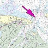
If you are a recreational boater, fisherman, or another member of the maritime community, NOAA's Office of Coast Survey wants to pick your brain about the "magenta line," which historically depicted the recommended route for the Intracoastal Waterway Route (IWR) on NOAA nautical charts. A recent Federal Register Notice outlines NOAA's options for improving the accuracy of the magenta line, which is presently being removed from new editions of nautical charts. Federal funding does not allow for consistent maintenance of the 3…
NOAA Finds Lost 19th Century U.S. Coast Survey Steamer

More than 153 years after it was lost in a violent collision at sea, government and university maritime archaeologists have identified the wreck of the ship Robert J. Walker, a steamer that served in the U.S. Coast Survey, a predecessor agency of NOAA. The Walker, while now largely forgotten, served a vital role as a survey ship, charting the Gulf Coast ‒ including Mobile Bay and the Florida Keys ‒ in the decade before the Civil War. It also conducted early work plotting the movement of the Gulf Stream along the Atlantic Coast.
Subsea Wreck Identifed Off NJ Coast 153 Years On

Lost after a violent collision at sea, government and university maritime archaeologists have identified the wreck of the ship 'Robert J. Walker', a steamer that served in the U.S. Coast Survey, a predecessor agency of NOAA. Twenty sailors died when the Walker sank in rough seas in the early morning hours of June 21, 1860, ten miles off Absecon Inlet on the New Jersey coast. The crew had finished its latest surveys in the Gulf of Mexico and was sailing to New York when the Walker was hit by a commercial schooner off New Jersey.
New Edition of Seminal US Coast Pilot
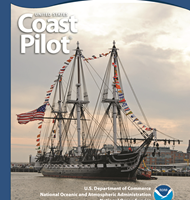
The United States Coast Pilot, with one of the Nation’s longest publishing records, like fine wine, improves with age. The United States Coast Pilot®, originally called the American Coast Pilot, has been published for over 200 years. This set of sailing directions for U.S. coastal waters has kept millions of mariners safe from perils at sea. Recently, NOAA’s Office of Coast Survey unveiled yet another improvement to the nine-volume set geared to modern mariners who need updated information as soon as it becomes available.
NOAA Unveils Collection of Civil War Maps and Nautical Charts
In honor of the 150th anniversary of the Civil War in 2011, NOAA has assembled a special historical collection of maps, charts, and documents prepared by the U.S. Coast Survey during the war years. The collection, “Charting a More Perfect Union,” contains over nearly 400 documents, available free from NOAA’s Office of Coast Survey website. “People are planning now for their visits to Civil War sites next year, and we want to give them an opportunity to visualize the terrain, ports, and coasts as they were from 1861 to 1865,” said Meredith Westington, NOAA’s chief geographer. Coast Survey’s collection includes 394 Civil War-era maps, including nautical charts used for naval campaigns, and maps of troop movements and battlefields.


