

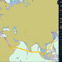
Voyage Planning Tool Errors Contributed to Grounding
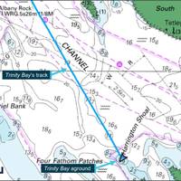
The use of a draft voyage planning tool which included waypoint data errors plus an ongoing technical fault with the vessel monitoring and surveillance system for the Great Barrier Reef contributed to a cargo ship’s grounding on a shoal, the Australian Transport Safety Bureau (ATSB) has concluded.The 81-meter general cargo ship Trinity Bay grounded on Harrington Shoal, a charted feature with a depth of 0.9 metres north-west of Harrington Reef, on the morning of January 19, 2021 while conducting a regular weekly passage from Thursday Island to Cairns.
ChartWorld Launches Digital Voyage Planning Tool
ChartWorld has launched MyFleet, a free-of-charge cloud-based tool designed to support onshore teams to check and assess risk in a ship’s voyage plan,Following recent legal decisions, voyage plan due diligence by the vessel owner or ship manager has taken on increased, and urgent importance. Oliver Schwarz, ChartWorld’s Business Development Director, said, “A ship being ‘at sea’ is no longer a viable or legal defense for lack of shore-based oversight. Improvements in communications…
Partners Unveil New Digital Operations Tool
Navigation solutions provider Marine Press, environmental product and services company Total Marine Solutions and maritime software and technology firm Brenock have partnered to advance digital transformation in the maritime industry.In an exclusive arrangement announced today at Marine Money, Marine Press will offer Total Marine Solution’s Ocean Guardian as an embedded software in its SeaPassage suite of integrated e-navigation solutions.“Bringing Ocean Guardian to Marine Press clients is a significant step forward in transforming the industry. It creates the most comprehensive digital navigation and voyage planning tool on the market – a seamless product that simplifies onboard decision making and voyage planning…
UKHO Launches New Routing Charts
The United Kingdom Hydrographic Office is launching a new large-scale routing chart covering the busy shipping waters of Vietnam, Indonesia and the Malacca Strait. Routing Chart 5141 is the latest addition to the UKHO's routing chart series and will be published on February 27, 2014. As well as covering a very busy shipping area, Routing Chart 5141 has been compiled in a larger scale than the UKHO's existing routing charts and features more detailed and up-to-date meteorological and currents information.
UKHO Publish World's First Security Paper Charts
The United Kingdom Hydrographic Office's (UKHO) security charts are designed to protect against risks, including piracy. The two new Admiralty Maritime Security Charts, cover the waters around India and Southeast Asia, including the Malacca Straits. These paper charts provide a single point of reference for recording the most up-to-date security information and, taken together with the UKHO’s three existing security and piracy charts, create the world’s first suite of security planning charts. Admiralty Maritime Security Charts are designed to be used by ship personnel, shore-based managers and security specialists as a key voyage planning tool for recording the latest security-critical navigational information…


