

Global Reef Expedition: Mission to Tonga

Assessing the health of coral reefs in the Kingdom of TongaHealthy coral reefs provide critical ecosystem services for millions of people globally, but with climate change and anthropogenic stressors, the landscape of these habitats is regularly shifting. The science and conservation community has realized the importance of baseline studies to help track how these precious reef ecosystems are changing. The Khaled bin Sultan Living Oceans Foundation launched the Global Reef Expedition…
Transas Launches Web Map Service
Transas Marine has launched Transas Web Map Service (WMS)to provide transparent and easy access to navigation charts through common interface. Access to comprehensive mapping data is a powerful tool for developers of online web-based and mobile apps who can now use Transas’ top-notch technology to build their own applications. Transas WMS incorporates the company’s renowned TX-97 chart collection and guaranteesfast and reliable chart viewing service with a worldwide coverage.Developers of custom mapping applicationswith web access features can now use Transas TX-97 map tiles. Efficient tile caching ensures maximum performance even in most demanding scenarios, allowing a large number of simultaneous users to access the service without any adverse impact on speed and quality.
HYPACK Automatic Download of ENC Charts
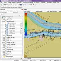
The new HYPACK feature allows U.S.-based users to quickly obtain the most recent charts provided by NOAA and the USACE at no additional charge. U.S.-based users who have an Internet connection will be able to download the charts from the USACE and NOAA web-map servers with the click of a button. Both agencies have made their charts available for download, and HYPACK has made it easy to ensure users have the latest chart data. Step One: Update ENC Catalog: HYPACK downloads the latest chart catalogs over the Internet from the NOAA and USACE map servers.
NOAA Nautical Charts Now Permanently Free

After a three-month trial period, PDF versions of NOAA nautical charts will become a permanent product, free to the public. The free PDFs, which are digital images of traditional nautical charts, are especially valued by recreational boaters who use them to plan sailing routes and fishing trips. The free PDF charts are part of a suite of new and enhanced navigational products designed to make NOAA’s data more accessible to the general public. “Up to date charts help boaters avoid groundings and other dangers to navigation…
NOAA Unveils New Electronic Chart Online Viewer
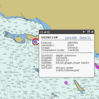
For more than ten years, since NOAA introduced its electronic navigational charts, you have needed to purchase a specialized chart display system to view the NOAA ENC® as a seamless chart database. Starting today, you don’t need a system to view the ENC depictions; you can use Coast Survey’s new web-based viewer called NOAA ENC® Online . (IMMEDIATE CAVEAT: You still need a specialized display system to use the multi-layered functional data that make ENCs so valuable. Since NOAA ENC Online is web-based, there is nothing to download.
Transas Rolls Out New FleetViewOnline
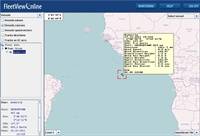
New version of Transas Marine FleetViewOnline 3.11 SSAS and Tracking service. In today’s world economy, fleet management becomes more and more essential where information is a key. In response to this, Transas Marine introduces a new version of its fleet SSAS and tracking service FleetViewOnline 3.11. FleetViewOnline 3.11 offers its users three alternatives for electronic charts presentation; Transas Marine proven TX-97 charts with worldwide coverage, OpenSteetMaps land charts and any charts provided by Web Map Service.
Horizon Marine adds Web Mapping Service to Eddy Watch
Horizon Marine has added a new Web Mapping Service (WMS) to its suite of web-based mapping products available to Eddy Watch subscribers. This new product allows clients to import Horizon Marine’s proprietary data into their own Geographic Information System (GIS). These data layers include tropical storm tracks, GPS drifter data, Loop Current and eddy fronts, satellite imagery, and forecast charts. Once the Horizon Marine WMS has been added to an end user’s GIS, the layers continually update, eliminating the need for clients to add new layers just to update their maps. This new WMS seamlessly integrates into GIS applications such as ESRI’s ArcGIS and is compliant with the standards for Web Map Services as laid out by Open Geospatial Consortium, Inc.


