NOAA’s Coast Survey Plans for New Arctic Nautical Charts

Press Release
Thursday, February 28, 2013
File NOAA
NOAA's planned charts of the Arctic.

Less sea ice and more ship traffic means new charts needed for safety.


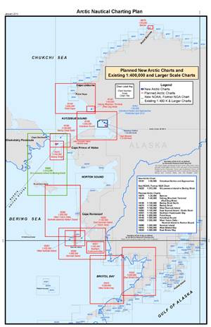
NOAA’s Office of Coast Survey has issued an updated Arctic Nautical Charting Plan, as a major effort to improve inadequate chart coverage for Arctic areas experiencing increasing vessel traffic due to ice diminishment. The update came after consultations with maritime interests and the public, as well as with other federal, state, and local agencies.


“As multi-year sea ice continues to disappear, vessel traffic in the Arctic is on the rise,” said Rear Admiral Gerd Glang, NOAA Coast Survey director. “This is leading to new maritime concerns about adequate charts, especially in areas increasingly transited by the offshore oil and gas industry and cruise liners.”


“Given the lack of emergency response infrastructure in remote Arctic waters, nautical charts are even more important to protect lives and fragile coastal areas,” Glang said.


Commercial vessels depend on NOAA to provide charts and publications with the latest depth information, aids to navigation, accurate shorelines, and other features required for safe navigation in U.S. waters. But many regions of Alaska’s coastal areas have never had full bottom bathymetric surveys, and some haven’t had more than superficial depth measurements since Captain Cook explored the northern regions in the late 1700s.


“Ships need updated charts with precise and accurate measurements,” said Capt. Doug Baird, chief of Coast Survey’s marine chart division. “We don’t have decades to get it done. Ice diminishment is here now.”


NOAA plans to create 14 new charts to complement the existing chart coverage. For example, seven of the charts will complete chart coverage from the Alaska Peninsula to Cape Lisburne at the edge of the North Slope, and more charts support the future maritime transportation infrastructure in the coastal areas north of the Aleutian Islands.


NOAA has been taking stakeholder feedback since the first Arctic Charting Plan was issued in 2011. One improvement called for additional detail to the Kotzebue Harbor and Approaches chart, which was published as the first plan-inspired new chart, in April 2012.


Mariners and the interested public can submit comments through the Coast Survey Inquiry and Discrepancy System online.


These latest efforts also support the objectives of the National Ocean Policy that foster understanding of changing conditions in the Arctic, and focus on ocean, coastal, and Great Lakes observations, mapping, and infrastructure by strengthening mapping capabilities into a national system and integrating that system into international observation efforts.


NOAA’s Office of Coast Survey is the nation’s nautical chartmaker. Originally formed by President Thomas Jefferson in 1807, Coast Survey updates charts, surveys the coastal seafloor, responds to maritime emergencies, and searches for underwater obstructions that pose a danger to navigation.

Email AddThis Feed Button
Maritime Reporter May 2013 Digital Edition
FREE Maritime Reporter Subscription
Latest Maritime News    rss feeds

Offshore

Leevac Wins HOS Shipbuilding Contract

Leevac Shipyards Jennings LLC, of Jennings, LA, a subsidiary of Leevac Shipyards, LLC signed contracts with Hornbeck Offshore Services, LLC, an affiliate of Hornbeck Offshore Services, Inc.

Harkand Set to Acquire Veolia Marine Services

Harkand, the international subsea inspection, repair, maintenance and light construction group, announced an agreement to acquire the main assets and business of Veolia Marine Services (VMS).

China Shipyards' MacGregor Order Bonanza

MacGregor offshore winches for 22 new anchor handling tug supply vessels (AHTSVs) under construction at three shipyards. MacGregor, part of Cargotec, has secured

Navigation

Insights: Rear Admiral Joseph A. Servidio

Assistant Commandant for Prevention Policy United States Coast Guard Rear Admiral Joseph A. Servidio is Assistant Commandant for Prevention Policy overseeing Inspections and Compliance,

Hydrographers Take Steps Towards an e-Navigation Web

The Hydrographic Society UK, supported internationally, is arranging a conference: ' Digital Hydrography on the Maritime Web'. The Hydrographic Society UK (THS UK),

Green Lights on Singapore Strait TSS Crossing

IMO's Maritime Safety Committee has adopted an earlier recommendation that ships display 3 all-round green lights when crossing the Singapore Strait Traffic Separation Scheme (TSS).

Environmental

Ro-Ro Specific EEDI Approval Welcomed by Interferry

A sector-specific Energy Efficiency Design Index (EEDI) for new ro-ro cargo & ro-pax vessels has been agreed by the IMO Marine Environment Protection Committee – MEPC 65.

IMO to Shed Light on HME Disposal Confusion

Guidance circular to be issued for ships calling at ports without reception facilities for Harmful to the Marine Environment (HME) waste, including Hold Washing Water (HWW).

PSSA Interactive Display Launched at IMO

A new interactive display on Particularly Sensitive Sea Areas (PSSA) has been launched at IMO Headquarters and online at www.pssa.imo.org. A PSSA is an area

News

Ro-Ro Specific EEDI Approval Welcomed by Interferry

A sector-specific Energy Efficiency Design Index (EEDI) for new ro-ro cargo & ro-pax vessels has been agreed by the IMO Marine Environment Protection Committee – MEPC 65.

Georgia Port Reports Highest Tonnage on Record

Georgia Ports Authority (GPA) moved 2.4 million tons of cargo in April, a 4.7 percent increase – or 108,532 tons – over the same month a year ago. This figure was

U.S. Coast Guard Accepts Nine BWTS as AMS

Followers of the Ballast Water Treatement System (BWTS) situation (ie. presumably anyone reading this publication) were heartened last month when the U.S Coast

Maritime Safety

Insights: Rear Admiral Joseph A. Servidio

Assistant Commandant for Prevention Policy United States Coast Guard Rear Admiral Joseph A. Servidio is Assistant Commandant for Prevention Policy overseeing Inspections and Compliance,

Emergency Personnel Participate in Oil Spill Response Program

Nearly 250 first responders participated in a National Preparedness Response Exercise Program in Los Angeles including U.S. Coast Guard, Chevron, California Department

MOL Completes Containership Collision Drills

Mitsui O.S.K. Lines, Ltd. (MOL) announced the completion of a tabletop drill done in cooperation with the fifth Regional Coast Guard Headquarters. The scenario

Vessels

China Shipyards' MacGregor Order Bonanza

MacGregor offshore winches for 22 new anchor handling tug supply vessels (AHTSVs) under construction at three shipyards. MacGregor, part of Cargotec, has secured

Insights: Rear Admiral Joseph A. Servidio

Assistant Commandant for Prevention Policy United States Coast Guard Rear Admiral Joseph A. Servidio is Assistant Commandant for Prevention Policy overseeing Inspections and Compliance,

Gibdock Refits WesternGeco Seismic Vessel

Gibdock completed a refit of the seismic vessel WG Cook for WesternGeco. WG Cook is one of six 12-streamer 3D seismic ships delivered to the owner in 2010. The

Arctic Operations

Coast Guard Initiates Arctic Shield 2013

The Coast Guard 17th District announced its Arctic Shield 2013 plans to protect the maritime community in the Arctic and to strengthen their partnerships with federal,

Aker Arctic Brings Oblique Ice Breaker to Market

With construction underway on the first ever Oblique Icebreaker, research specialist Aker Arctic Technology  has unveiled a new version of the vessel type that

Polar Petroleum Appoints ARCO Alaska Veteran

Polar Petroleum Corp. appointed Mr. Donald W. Brizzolara to the Company's Advisory Board as Chief Geological Advisor. Mr. Brizzolara represents 25 years of experience


mobi | rss feeds | archive | history | articles | privacy | contributors | top news | about us | copyright