

NOAA and American Pilots’ Association Partner to Enhance Navigation Safety

On July 17, 2023, senior leaders of the American Pilots’ Association (APA) and the National Oceanic and Atmospheric Administration (NOAA), National Ocean Service, Office of Coast Survey signed a Memorandum of Agreement (MOA) that calls for the two parties to cooperate and share information so that APA and NOAA can better carry out their respective roles and responsibilities related to safe maritime navigation in America’s ports and waterways. Rear Admiral Benjamin Evans (Director…
ACBL to Pay Over $2 Million for Mississippi River Oil Spill
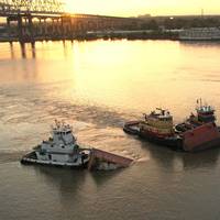
Jeffersonville, Ind.-based barging company American Commercial Barge Line (ACBL) has agreed to acquire and preserve 649 acres of woodland wildlife habitat and will pay an additional $2 million for damages stemming from a 2008 oil spill on the Mississippi River, near New Orleans.The company has already paid $1.32 million to reimburse the federal and state trustees for their past damage assessment and restoration planning costs after one of its barges discharged approximately 6,734 barrels (282,828 gallons) of No. 6 fuel oil into the Mississippi River upriver of New Orleans in July 2008.
Living Shorelines Blunt Effects of Climate Change, Says NOAA
A recent NOAA study, published in the journal PLOS One, shows “living shorelines” — protected and stabilized shorelines using natural materials such as plants, sand, and rock — can help to keep carbon out of the atmosphere, helping to blunt the effects of climate change. This study, the first of its kind, measured carbon storing, or “carbon sequestration,” in the coastal wetlands and the narrow, fringing marshes of living shorelines in North Carolina. “Shoreline management techniques like this can help reduce carbon dioxide in the atmosphere while increasing coastal resilience,” said Russell Callender, Ph.D., acting director of NOAA’s National Ocean Service. Carbon can be stored or “sequestered” in plants when they take carbon dioxide from the atmosphere during photosynthesis.
Large Dead Zone Found in Gulf of Mexico
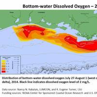
Mapped size confirms NOAA forecast for an average-sized hypoxia zone this year. NOAA- and EPA-supported scientists have mapped the Gulf of Mexico dead zone, an area with low oxygen water, measuring 5,052 square miles this summer--approximately the size of the state of Connecticut. The measurements were taken during the 30th annual hypoxia survey cruise from July 27 to August 2. This area falls within the predicted range of 4,633 to 5,708 square miles forecast by a suite of NOAA-sponsored models…
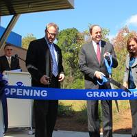
Jacksonville Adds PORTS Real-time Data System
Officials from NOAA, the Jacksonville Marine Transportation Exchange, and the Jacksonville Port Authority officially dedicated a new information system today which will increase safety for ships using the St. Johns River. The system, called Physical Oceanographic Real-Time System (PORTS), provides real-time information on water levels, currents, meteorological conditions, and under-bridge clearance, giving users critical information when traveling through the river. The St. Johns River in Jacksonville will become the 23rd location to use the system and is the second largest PORTS ever established. “Our nation’s ports are critical cogs in our country’s economic engine,” said Kathryn D. Sullivan, Ph.D., under secretary of commerce for oceans and atmosphere and NOAA administrator.
NOAA Offers a New Way to See Currents
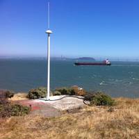
A new NOAA National Ocean Service website will provide mariners near real-time coastal ocean surface current observations and tidal current predictions in coastal waters using high frequency (HF) radar, making marine navigation safer for mariners and commercial shippers. The web-based observations are now available for the Chesapeake and San Francisco Bays in areas vital for marine navigation, with additional locations to follow. The product was made possible by NOAA’s Center for Operational Oceanographic Products and Services (CO-OPS) using data from the NOAA-led U.S.
AAPA Applauds Port Infrastructure Funding
In applauding Congress’ passage late yesterday of the $1.1 trillion Consolidated Appropriation Act of 2014, the American Association of Port Authorities (AAPA) noted that several high priority programs crucial to the safe, efficient and competitive operation of American seaports are included in the appropriations mix. This includes funding for U.S. DOT’s Transportation Infrastructure Generating Economic Recovery (TIGER) discretionary grants, U.S. Corps of Engineers’ navigation-related programs…
Gulf of Mexico Disaster Response Center Opened
NOAA brings to bear centralized disaster planning, response expertise to the Gulf of Mexico region from its new Mobile, Alabama, office. NOAA's new Gulf of Mexico Disaster Response Center (DRC) promises to change the way people prepare for and respond to the many hard-hitting storms, spills, and other events that too often strike this fragile region. The new 15,200-square foot facility will serve as a central coordination point for federal, state and local emergency managers,…
Hydrographic Services Review Panel Meeting
The NOAA Hydrographic Services Review Panel will meet Oct. 12-13, in Vancouver, Wash., to discuss operations, research and development, hydrographic surveying, nautical charting, and geodetic and geospatial measurements. The panel is a Federal Advisory Committee that advises the NOAA administrator on carrying out NOAA’s navigation services mission — to ensure the safe, efficient, and environmentally sound movement of commerce along America’s marine transportation system. The panel will hear from representatives from the maritime community, including port authority officials and marine pilots, as well as non-traditional users of navigation data like coastal planners and emergency responders.
Polar Tankers to Pay $588K for 2004 Spill
Polar Tankers Inc., a subsidiary of ConocoPhillips Co., has agreed to pay $588,000 to help compensate the public for environmental harm caused by the October 2004 crude oil spill into Puget Sound’s Dalco Passage near Tacoma. The payment would come under a proposed settlement agreement or consent decree filed this week in U.S. District Court, Western Washington Division involving Polar Tankers and the United States, state of Washington, Muckleshoot Indian Tribe and Puyallup Tribe of Indians. A consent decree in federal court makes no finding of guilt or innocence. The U.S. Attorney General’s action was made at the request of the National Oceanic and Atmospheric Administration and the U.S.
Restoration Begins for T/V Westchester Spill
Federal and Louisiana agencies settled with Marine Oil Trader 3, Ltd. and Ermis Maritime Corp. for the November 2000 T/V Westchester oil spill into the Mississippi River in Plaquemines Parish, La. With oversight from the Commerce Department’s National Oceanic and Atmospheric Administration (NOAA), U.S. Department of the Interior’s U.S. restoration projects to address the resources injured by the spill. On Nov. 28, 2000, the T/V Westchester grounded in the Mississippi River at River Mile 38, discharging approximately 500,000 gallons of crude oil into the Mississippi River downstream from New Orleans in Plaquemines Parish, La. hunting opportunities. to conduct a natural resource damage assessment to identify and restore injured natural resources.
NOAA Announces New Ports Program for New Haven
install a new Physical Oceanographic Real-Time System. oceanographic and meteorological data. NOAA is an agency of the U.S. Department of Commerce. annually. the water. off. make marine transportation both safe and efficient. administrator of NOAA's National Ocean Service. effort with the Block Island Pilots Association. quality control and data dissemination. thoroughly quality controlled to ensure accuracy. accessible by Internet or phone. include port authorities, vessel pilots, shipping companies, U.S. Guard, U.S. environmental organizations, academia and surfers. using the highly successful NOAA program. and Tacoma, Wash. understanding, conserving and restoring the nation's coasts and oceans. sustaining coastal habitats and mitigating coastal hazards. resources.
Corso Named Deputy Assistant Administrator for Ocean Service
William Corso has been appointed as the new deputy assistant administrator for NOAA's National Ocean Service. Corso will officially assume his duties on November 20. Corso has spent the past seven years working for Lockheed Martin. Currently, he directs the diversified projects group at Stennis Space Center, Bay St. Louis, Miss. He is responsible for cost, schedule, and technical performance of programs supporting government agencies at the Center, including software development in support of naval oceanographic operations worldwide and contributions to the conceptual design of the Integrated Ocean Observing System. Corso also has been director of Lockheed Martin’s remote sensing program…
Raytheon Wins NOAA Contract
Raytheon Company's Intelligence and Information Systems business has been awarded a six-month, competitive contract by the National Oceanographic & Atmospheric Administration's (NOAA) National Ocean Service to develop a conceptual design, life-cycle cost estimate and viability narrative for the Integrated Ocean Observing System (IOOS). IOOS is a significant component of the emerging Global Earth Observation System of Systems, a global monitoring network involving NOAA, federal partners, and nearly 60 countries. Raytheon will perform the work at its Aurora, Colo., Pasadena, Calif., and Reston, Va., sites.
New System Increase Safety Measures for NY/NJ Ports
Mariners calling on the Port of New York/New Jersey will now have a new tool to assist them navigate safely through the harbor. water levels and current conditions. Administration (NOAA). the Port of New York/New Jersey. plots, and animations of water levels and currents. limiting passage times, without compromising safety. The system is run in both nowcast and forecast modes. System (PORTS(r)). times a day. numerical models. (CBOFS). the Port of Houston. meteorological and oceanographic data. Water Level Program, the national network of PORTS(r) in major U.S. harbors, and the National Current Program.
U.S. ENC Availability Starts to Gain Speed
It is no secret that acceptance and incorporation of electronic charting systems has been more widespread in Europe than in the U.S., as European governments and commercial organizations collectively have worked more diligently together and built and maintained a lead in this area. The gap, however, is closing, as the era of the electronic chart is quickly arriving in the U.S. In a recent Advance Notice of Proposed Rulemaking (ANPRM), the U.S. Coast Guard announced that it is considering the feasibility of allowing commercial vessels to use electronic charting and navigation systems as their primary means of navigation in U.S. waters. It would have to meet ECDIS standards as supplied by the IMO.
News Briefs
First Wave/Newpark Shipbuilding, in Galveston, Texas, has had a busy spring. First, the company was awarded a contract by Diamond Offshore Drilling to install a crane and perform annual survey work on Ocean Lexington. That contract was completed in March. Next, the company won a contract from Smit Americas, Inc. for drydocking of Ocean Hercules. The vessel was drydocked on the shipyard's 7,500-ton drydock for general maintenance and conversion from a seismic vessel to a telecommunication cable laying vessel. Finally, First Wave drydocked Pride Louisiana for Pride Offshore. The rig was docked in the Galveston Ship Channel, utilizing a heavy lift barge for an annual survey. The rig will depart upon completion of the survey.
NOAA to Christen New Research Vessel
NOAA's Channel Islands National Marine Sanctuary will christen its new research vessel on May 12. sanctuary use. emerging management issues. Frank Kelly, Santa Barbara Harbor Commissioner Captain Ted I. Lillestolen (NOAA Corps), associate deputy assistant administrator for NOAA's National Ocean Service, Daniel J. Basta, director, National Marine Sanctuary Program and Chris Mobley, manager, Channel Islands National Marine Sanctuary.


