

NOAA Cuts Ribbon on Renovated Ketchikan Port Facility
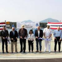
Federal, tribal, state and local officials joined NOAA leadership to cut the ribbon on the agency’s newly renovated port facility in Ketchikan, Alaska. The celebration was held to dedicate the facility and recognize the important partnerships in the area.The facility will provide vessel support for NOAA research ships. The facility will also support NOAA Ship Fairweather, which is homeported in Ketchikan.“Having a home base for NOAA to operate from in Alaska is integral to our science…
Thoma-Sea Awarded Contract to Build Two NOAA Research Ships
Houma, La. shipbuilder Thoma-Sea Marine Constructors has been awarded a contract to design and build two new research vessels for NOAA, for expected delivery in 2027 and 2028.The $624.6 million deal was awarded following a request for proposals that was open June–October 2022 and includes purchase options for up to two more vessels.The new ships will be less than 90 meters long, engineered to focus primarily on ocean mapping and nautical charting as part of NOAA’s mission to deliver tools and information to help mariners safely navigate the nation’s ports and harbors.
Keel Laid for NOAA’s New Oceanographic Research Ship
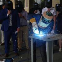
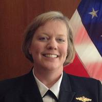
Houma, La. shipbuilder Thoma-Sea Marine Constructors hosted a keel-laying ceremony for NOAA’s newest oceanographic research ship, Oceanographer.“Today’s keel-laying ceremony marks a major step forward both in the construction of Oceanographer and the revitalization of NOAA’s ship fleet,” said Rear Adm. Nancy Hann, director of NOAA’s Office of Marine and Aviation Operations (OMAO) and the NOAA Commissioned Officer Corps.Oceanographer is one of two ships being built for NOAA by TMC to support a variety of missions…
Rear Admiral Hann Confirmed to NOAA Leadership Post
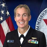
The U.S. Senate confirmed on Tuesday evening President Biden’s nomination of NOAA Rear Admiral Nancy Hann to lead the NOAA Office of Marine and Aviation Operations (OMAO) and NOAA Commissioned Officer Corps (NOAA Corps), one of the nation’s eight uniformed services.“From flying into hurricanes to crewing remote explorations to the deepest depths of the ocean, the NOAA Corps drives NOAA’s science forward,” said U.S. Secretary of Commerce Gina M. Raimondo. “Rear Admiral Hann’s leadership…
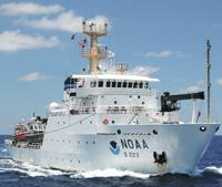
NOAA's New Ocean Exploration Ship to Be Based in Newport, RI
Newport, R.I. has been chosen as the future homeport for a new NOAA oceanographic research vessel being built for the agency. Discoverer will be a state-of-the-art ship that operates around the nation and the world to study and explore the ocean.“Discoverer will be one of the world’s most advanced research vessels,” said Rear Adm. Nancy Hann, deputy director for operations for NOAA’s Office of Marine and Aviation Operations (OMAO) and deputy director of the NOAA Commissioned Officer Corps.
NOAA Sets Up Vessel Ops Support in Rhode Island
NOAA has awarded a lease to Massa Industries, LLC for office space in Middletown, R.I., that will temporarily house a new marine operations support facility for Rhode Island-based NOAA ships Henry B. Bigelow and Okeanos Explorer.The Middletown facility will also support NOAA personnel engaged in the design and construction of a new pier for the two ships and a permanent NOAA marine operations support facility at Naval Station Newport. NOAA expects to occupy the interim facility in the fall of 2020 and relocate it to the naval station in 2023.“With an expanded presence in Rhode Island…
Congress Responds to COVID19 and Other Challenges for the Maritime Industry

In response to the worldwide COVID-19 pandemic, the Congressional Research Service released a report that stated global economic growth has declined by 3% to 6% in 2020 with a partial recovery predicted for 2021. Also, the GDP of the U.S. has fallen by 5% in the first quarter 2020. According to the International Maritime Organization (IMO), the maritime industry, and seafarers themselves, have not been able to escape the significant effects of this crisis.All sectors of the maritime industry have been adversely affected by the global pandemic.
NOAA to Order New Research Ships in 2020
The U.S.' National Oceanic and Atmospheric Administration (NOAA) said it expects to award contracts for the construction of two new oceanographic ships by the end of the year. Once in service, the new large oceangoing, multi-mission research vessels will support missions ranging from general oceanographic research and exploration to marine life, climate and ocean ecosystem studies, NOAA said.“When completed, these new state-of-the-art ships will be vital for collecting high-quality data and leading scientific discoveries,” said Neil Jacobs, Ph.D., acting NOAA administrator.
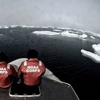
NOAA Deploys Survey Ships for Arctic Charting Projects
NOAA announced the official launch of its 2015 Arctic hydrographic survey season took place this morning, in Kodiak, Alaska, in a World Ocean Day ceremony which showcased the deployment of the NOAA ships Rainier and Fairweather. “Most Arctic waters that are charted were surveyed with obsolete technology, with some of the information dating back to Captain Cook's voyages, long before the region was part of the United States,” said NOAA deputy under secretary for operations Vice Admiral Michael S. Devany in remarks directed to the crews of NOAA ships.
NOAA to Boost Arctic Nautical Charting
NOAA plans increased 2015 Arctic nautical charting operations, coordinating with U.S. As commercial shipping traffic increases in the Arctic, NOAA informs it is taking steps to update nautical charts in the region. NOAA’s Office of Coast Survey will use data collected by two of its own ships, Rainier and Fairweather, as well as the U.S. Coast Guard cutter Healy and a private sector hydrographic contractor to cover nearly 12,000 nautical miles in the Arctic for use in updating its navigational charts.
New Lineup for NOAA Hydrographic Services Panel
NOAA administrator Kathryn Sullivan, Ph.D., has appointed six members to the Hydrographic Services Review Panel, a federal advisory committee that gives NOAA independent advice for improving a range of services and products that support navigation and coastal resilience. Capt. “Providing coastal communities, boaters, and the commercial maritime industry with timely, reliable, accurate, and authoritative information is essential as we strive to keep commerce flowing through our nation’s ports,” Sullivan said. Rear Admiral Ken Barbor (ret.), U.S. Lawson W. Capt. Gary A. Scott R.
USCG, NOAA Ink Fleet Plan Agreement
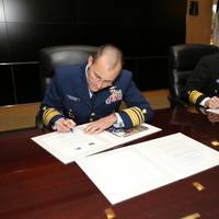
Senior leaders from the U.S. Coast Guard (USCG) and the National Oceanic and Atmospheric Administration (NOAA) signed a Fleet Plan and Officer Exchange memorandum of understanding Wednesday at a ceremony at U.S. Coast Guard Headquarters. Coast Guard Vice Adm. Charles Michel, deputy commandant for operations, and NOAA Vice Adm. Michael Devany, deputy under secretary for operations, were the signing officials for the joint letter of promulgation. The Coast Guard and NOAA have collaborated for more than 200 years.
Lynch Takes Helm of NOAA’s Atlantic Fleet
NOAA Capt. Anne K. Lynch has assumed command of the agency's Marine Operations Center-Atlantic in Norfolk, Va., which manages the day-to-day operations of the nine research and survey ships in NOAA's Atlantic fleet. Each year these ships conduct dozens of missions to assess fish and marine mammal stocks, conduct coral reef research, collect seafloor data to update nautical charts, and explore the ocean. Lynch relieves NOAA Corps officer Anita Lopez, who has served as the center's commanding officer since June 2012.
NOAA Finds Lost 19th Century U.S. Coast Survey Steamer
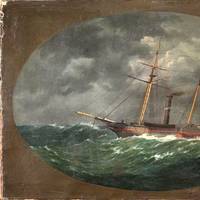
More than 153 years after it was lost in a violent collision at sea, government and university maritime archaeologists have identified the wreck of the ship Robert J. Walker, a steamer that served in the U.S. Coast Survey, a predecessor agency of NOAA. The Walker, while now largely forgotten, served a vital role as a survey ship, charting the Gulf Coast ‒ including Mobile Bay and the Florida Keys ‒ in the decade before the Civil War. It also conducted early work plotting the movement of the Gulf Stream along the Atlantic Coast.
MSI to Train NOAA Officers
Maritime Simulation Institute to Provide Professional Maritime Training to NOAA Officers; Instruction to Include Critical Simulator Experience in Shiphandling at Institute Headquarters. The Maritime Simulation Institute was recently selected to provide professional maritime training to National Oceanic and Atmospheric Administration (NOAA) Corps Officers. In the NOAA Basic Officer Training Class, professional maritime instructors from the Maritime Simulation Institute will train the initial accession NOAA Corps Officers in the nautical sciences including basic safety training, seamanship, electronic navigation, ship stability, Rules of the Road, and shiphandling.
NOAA Finalizes Plans for 2011 Survey Season
As the new year approaches, NOAA ships and independent contractors are preparing for the nation’s 177th hydrographic surveying season, aiming to collect critically needed ocean and coastal mapping data for 2,525 square nautical miles in high-traffic coastal waters of the continental United States and Alaska. “The science of these surveys underpins the steady flow of commerce and the safety of mariners and coastal communities,” said NOAA Corps Capt. John E. Lowell, director of the Office of Coast Survey and U.S. national hydrographer. More than 13 million jobs are tied to maritime commerce which contributes more than $742 billion to the American economy. U.S.
Begich, Wicker, Schatz Introduce NOAA Corps Amendments Act

U.S. Senators Mark Begich, Roger Wicker (R-MS) and Brian Schatz (D-HI) introduced legislation to strengthen the National Oceanic and Atmospheric Administration’s (NOAA) Commissioned Officer Corps as a national asset and improve its ability to recruit and retain talented candidates like other uniformed services. Begich is chairman of the Senate Subcommittee on Oceans, Atmosphere, Fisheries and Coast Guard. Wicker and Schatz serve on the subcommittee as well. The NOAA Corps’ primary mission is to operate NOAA’s fleet of research ships and aircraft.
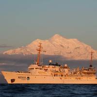
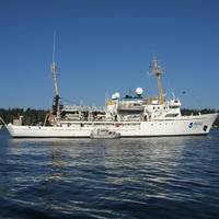
NOAA Fairweather Departs on Survey Mission
NOAA Ship Fairweather, a 231-foot survey vessel, departed Kodiak, Alaska, today on a mission to conduct hydrographic surveys in remote areas of the Arctic where depths have not been measured since before the U.S. bought Alaska in 1867. NOAA will use the data to update nautical charts to help mariners safely navigate this important but sparsely charted region, which is now seeing increased vessel traffic because of the significant loss of Arctic sea ice. Over the next two months, Fairweather will conduct hydrographic surveys covering 402 square nautical miles of navigationally significant waters in Kotzebue Sound, a regional distribution hub in northwestern Alaska in the Arctic Circle.
NOAA's Thomas Jefferson Conducting Surveys
NOAA Ship Thomas Jefferson conducts sea floor surveys to keep shipping safe along Long Island coast. NOAA Ship Thomas Jefferson continues today on a three-month survey of the sea floor off the coast of New York, Connecticut and Rhode Island, as part of a multi-year effort to update nautical charts for Block Island Sound and keep large ships and commerce moving safely. In addition to supporting marine navigation, data acquired by the 208-foot hydrographic survey vessel will also support a seafloor mapping initiative by Connecticut and New York.
NOAA Ship Rainier Returns to Alaska for Sea Floor Surveys
NOAA Ship Rainier returns to Alaska to conduct sea floor surveys in support of safe navigation. NOAA Ship Rainier has begun a month long survey of the sea floor near Alaska’s Prince of Wales Island as part of a multi-year effort to update nautical charts for the area. In addition to supporting marine navigation, data acquired by the 231-foot hydrographic survey vessel will also support marine ecosystem studies and improve inundation models for areas vulnerable to tsunamis. “We are pleased to return to Alaska to continue these important surveys…
Subsea Wreck Identifed Off NJ Coast 153 Years On
Lost after a violent collision at sea, government and university maritime archaeologists have identified the wreck of the ship 'Robert J. Walker', a steamer that served in the U.S. Coast Survey, a predecessor agency of NOAA. Twenty sailors died when the Walker sank in rough seas in the early morning hours of June 21, 1860, ten miles off Absecon Inlet on the New Jersey coast. The crew had finished its latest surveys in the Gulf of Mexico and was sailing to New York when the Walker was hit by a commercial schooner off New Jersey.
Sea Floor Surveys Support Texas Maritime Trade
This winter, NOAA will begin a year-long survey of the sea floor in the Port of Houston and Galveston Bay navigational areas, to aid efforts to bring more trade, more cargo, more jobs, and more economic benefits to the Houston area. The navigation survey team arrived in Galveston this week, to begin pre-survey preparations with mariners and federal partners. "With bigger ships, crowded sea lanes, and more uses of ocean areas, shipping today is increasingly a task of precision and accuracy," explained NOAA Corps Cmdr. Todd Haupt, chief of the Office of Coast Survey's Navigation Response Branch.
NOAA: New AK Chart Makes Arctic Safer

NOAA: New Alaska navigational chart makes increased Arctic shipping safer; Kotzebue Harbor chart replaces measurements last taken in 19th century. NOAA formally presented today to Alaska officials a new nautical chart for Kotzebue Sound in the Alaskan Arctic, a sparsely charted region that is seeing increased vessel traffic because of the significant loss of summer sea ice. The new chart depicts the full range of depth measurements and object detection acquired during a full ocean bottom survey last summer by the NOAA hydrographic survey ship Fairweather.


