

Fugro Mapping Arctic Waters off Norway
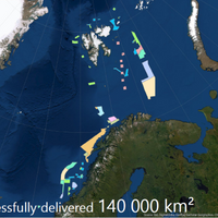
The Norwegian Hydrographic Service has awarded Fugro another hydrographic survey contract as part of the MAREANO seabed mapping program, financed by Norway’s Ministry of Trade, Industry and Fisheries, and the Ministry of Environment.Fugro said it has already completed 10 surveys for the program since 2006 and acquired over 140,000 km2 of data. This latest survey will collect high-resolution, high-density multibeam echosounder and sub-bottom data to produce seamless datasets for the Norwegian mapping program.
CSC Clarifies Continental Shelf Beyond Bouvet
The extent of the continental shelf beyond 200 nautical miles outside Bouvet Island has now been clarified with the Continental Shelf Commission (CSC) in New York.The Commission’s recommendation is in line with Norway’s proposal submitted to the Commission in 2009 and revised in 2015.According to a press note from Norwegian Petroleum Directorate (NPD), the Ministry of Foreign Affairs led the work on the shelf proposal.NPD, which is the State’s authority charged with geotechnical mapping of the continental shelf, has been responsible for preparing the technical and scientific documentation required by the UN Convention on Law of the Sea.
DNV Approves "Pay as You Sail" Charts Option
Global chart distributor Nautisk has confirmed DNV approval for its Neptune Pay As You Sail (PAYS) Solution. PAYS enables users to access global ENCs for use with onboard ECDIS systems, while only paying for those that are actually used. Peter J Pran, Nautisk Project Manager said, “Despite a positive market outlook, demands on shipowners and vessel operators to make cost savings and optimize operational efficiency are continuing to increase. “Our PAYS solution gives both shore-based and onboard teams access to any number of ENCs that may be required for one particular trading route.
SevenCs Conducts Capacity Building for Montenegro
After signing a RENC membership agreement with the Institute of Hydrometeorology and Seismology Montenegro (IHMS) PRIMAR and the Norwegian Hydrographic Service team up with SevenCs for capacity building. In November 2013, IHMS signed a RENC agreement with PRIMAR. Having a motivated team, paper charts and some recent surveys, IHMS was lacking a production environment and detailed knowledge in ENC production. Funded by the Norwegian Hydrographic Service, PRIMAR was able to provide its latest member with a full ENC production environment plus training.
Barents Sea Hydrograhpic Survey Contract For Fugro
Germany-based Fugro awarded Mareano, off North Norway coast, survey contract by the Norwegian Hydrographic Service (NHS). Fugro OSAE GmbH has been awarded a EUR 2.7 million hydrographic survey contract by the Norwegian Hydrographic Service (NHS). This survey, planned for 2013, is part of the on-going MAREANO project and will encompass an area over 11,000km2 in the Barents Sea. The area is located offshore the northern-most part of Norway, close to the Russian border, in water depths between 150 metres and 300 metres. The awarded survey is adjacent to an area surveyed by Fugro in 2011 and 2012.
Frode Klepsvik Joins NAVTOR Board
E-navigation company NAVTOR has further illustrated its ambitions within the maritime sector by appointing Frode Klepsvik, the former Director of the Norwegian Hydrographic Service, to the company’s board of directors. The appointment follows on just two months after the arrival of Tor Svanes, the founder of C-MAP Norway, in the position of Managing Director. Klepsvik has a unique pedigree within the maritime sector, boasting lengthy tenures with the Royal Norwegian Navy, where he climbed to the rank of Commander, and Det Norske Veritas, where he was responsible for Classification of Ships and Certification of Automation, Navigation and Integrated Bridge Systems.
Fugro Awarded NHS Survey Contract
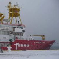
Fugro OSAE GmbH has been awarded a €2.3 million hydrographic survey contract by the Norwegian Hydrographic Service (NHS). The survey is part of the MAREANO project and will encompass an area over 12,000km² in the Barents Sea. The area is located 200km offshore in the northern-most part of Norway, near the Russian border, in water depth down to 300 metres. As the North Atlantic current keeps the waters in this area open and navigable most of the year, the survey will be carried out in early 2012. Data will be acquired by the survey vessel Victor Hensen using the new, high resolution Kongsberg EM2040 multibeam echo sounder. Processing will take place onboard the vessel and at Fugro OSAE’s processing centre in Bremen, Germany.
Norway, Brazil Sign Bilateral Agreement
The Norwegian Hydrographic Service (NHS) and the Directorate of Hydrography and Navigation (DHN) of the Brazilian Navy have signed a bilateral agreement to formalize the exchange of data, services, and sharing of expertise in the field of hydrography in order to enhance international maritime safety and protection of the environment and to avoid duplication of efforts between the participants. As a result of this agreement, Brazil now becomes a member of the PRIMAR regional ENC coordinating centre (RENC) operated by the NHS and will make the Brazilian ENCs directly available through the PRIMAR ENC service. Currently the ENC coverage in the Brazilian waters consists of 94 ENC cells.
NHS Establishes New RENCs
The Norwegian Hydrographic Service (NHS) and the United Kingdom Hydrographic Office (UKHO) have decided to establish two Regional ENC Coordinating Centres (RENCs) to meet the requirements of all Cooperating Hydrographic Offices (CHOs). The Norwegian Hydrographic Service will operate the RENC using current infrastructure and services in Stavanger, Norway - operative from 1 April 2002. “The NHS RENC is based on close cooperation between European HOs (CHOs), ensuring the HOs full control and continual access to their national RENC ENC product database,” said Kjell Birkevold, department director, Norwegian Mapping Authority. The fit-for-purpose and cost effective service by the NHS in Norway will be operated with established proven technology and infrastructure already used by Primar.
Big cuts in ENC prices from Primar Stavanger
international ENC coordinating center - have been slashed to their lowest-ever level. equivalent in size to the comparable paper chart. on the purchase price for a new ENC. subsequent annual renewals of a subscription. H. Johnsen at Primar Stavanger. Primar Stavanger service. marketing director for the Norwegian Hydrographic Service (NHS). user. authority, and thereby conforms to all relevant IMO and Solas regulations.
Estonia signs agreement with Primar Stavanger
Primar Stavanger, the international Electronic Navigational Chart (ENC) center operated by the Norwegian Hydrographic Service, has recently signed a cooperation agreement with Estonia. The center now covers more than 80 percent of all ENCs available in Europe, reports marketing manager Rune H. Johnsen at Primar Stavanger. Estonia has already made 31 ENCs available, which indicate that the whole coast of this Baltic state is covered. Of these, nineteen are coastal ENCs, five harbour ENCs and seven berthing ENCs. The increased coverage of ENCs in the Baltic with Primar Stavanger fits well with the declaration from the Helsinki Commission (Helcom) and national commitments. These focus on covering all major shipping routes and every major port in these waters with ENCs by the end of 2002.
Norwegian Hydrographic Joins With C-Map
The Norwegian Hydrographic Service has signed a contract with C-Map Norway for electronic navigational charts (ENC) and production of paper nautical charts. This long-term plan, which aims to cover the Norwegian coast with modern sea charts by 2006, will be accomplished with data and databases coming from Norwegian Hydrographic Services so that C-Map can produce S57 Edition 3 data, ENC S57 data as outlined in the ENC product specification and data for paper chart production. The contract's main elements involve production of new charts and reconstruction of new charts - with all production carried out under the terms of the contract based on S57 data…
Norway Signs Agreement with JHA
The Norwegian Hydrographic Service (NHS), operator of the Primar Stavanger electronic navigational chart (ENC) service, has signed a distribution agreement for Japanese ENCs with the Japan Hydrographic Association (JHA). Japan has full coverage of ENCs in usage bands from harbor to general. In addition, oceans around the country are covered with ENCs in overview scales. In total close to 600 ENCs, the Japanese coverage spans from Indonesia in the south to the Kamchatka Peninsula in the north, North Korea in the west and the Pacific as far as Hawaii in the east. The Pacific ENCs meet seamlessly with the American NOAA ENCs, also available from Primar Stavanger.In addition, Primar Stavanger will be able to distribute ENCs of the Malacca and Singapore Straits under this agreement.
U.K. Hydrographic Office Extends Chart Coverage
The United Kingdom Hydrographic Office (UKHO) is extending its coverage of navigational charts into Norwegian national waters in cooperation with the Norwegian Hydrographic Service (NHS). The new chart series will encompass Admiralty paper and ARCS charts, be fully corrected up to the date of issue, and supported by existing Admiralty services.


