More Arctic Norwegian Shelf Resources Mapped

Press Release
Wednesday, February 27, 2013
File Comparison of 2011/2012 Seismic Data
Comparison of 2011/2012 Seismic Data

The Norwegian Petroleum Directorate’s (NPD’s) mapping of the southeastern Barents Sea and the area surrounding Jan Mayen shows 15% increase.

The increase will result in an approximate increase of 15 per cent in the estimates of undiscovered resources on the Norwegian shelf which corresponds to about 390 million standard cubic metres (Sm3) of oil equivalents (o.e.). The mapping of these petroleum resources is a step in the authorities’ process to open these areas for petroleum activity.

Southeastern Barents Sea
The mapped area in the southeastern Barents Sea along the Russian border constitutes about 44 000 square kilometres. The NPD’s calculations show that expected resources total approx. 300 million Sm3 o.e., with an uncertainty range of 55 – 565 million Sm3 o.e. This means that the most pessimistic estimates lie at the low end of the spectrum, but that the petroleum volumes present could be considerably greater. Most of the resources in this part of the Barents Sea are expected to be gas. About 15 per cent are expected to be oil.
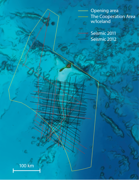
Jan Mayen
During the same period, the Norwegian Petroleum Directorate mapped possible petroleum resources in the sea area surrounding Jan Mayen. Seismic and aeromagnetic data, as well as numerous source rock samples, have been acquired in recent years in parts of the 100 000-square-kilometre area which may be opened.

The uncertainty regarding the area’s petroleum potential is considerable, because we have less knowledge here than, for example, in the southeastern Barents Sea where exploration wells have been drilled in adjacent areas already opened for petroleum activity. The expected resources in the Jan Mayen area are estimated at 90 million Sm3 o.e. The estimates indicate that there could be considerable resources in the area.


Email AddThis Feed Button
Maritime Reporter May 2013 Digital Edition
FREE Maritime Reporter Subscription
Latest Maritime News    rss feeds

Offshore

Offshore Wind Spend to Average $21B per year

Douglas-Westwood (DW) forecast offshore wind installations averaging 3.2 GW per year over the next ten years with capital expenditure hitting a peak of $24.1B in 2016.

Liebherr Delivers Heavy Lift Offshore Crane For “Vidar”

In June, components weighing up to 420 tonnes each for Liebherr’s new heavy lift offshore crane CAL 45000-1200 Litronic  were loaded from Liebherr MCCtec Rostock

TGS Starts Barents Sea 3D Seismic Survey

The 3D EM data is being acquired by the M/V 'Atlantic Guardian': data will be available to clients through both EMGS and TGS. The survey is supported by industry funding.

Arctic Operations

Port of Red Dog: Bulk Carriers' Call of the Wild

The UK P&I Club issue information for members whose vessels call at the remote Alaskan port on the Arctic Circle. Red Dog is a port established specifically to

Russian Companies Get Norwegian Arctic Offshore Licenses

Both Rosneft and Lukoil have secured license rights to blocks issued by the Norwegian government in Arctic waters. The massive opening of the Barents Sea for

Tideland Solar Buoys Mark Wrecks in Norwegian Arctic

Two SB-138P polyethylene buoys with solar-powered ML-140 LED lanterns from Tideland Signal are being used to mark wrecks in the approaches to the port of Narvik in the far north of Norway.

Offshore Energy

Offshore Wind Spend to Average $21B per year

Douglas-Westwood (DW) forecast offshore wind installations averaging 3.2 GW per year over the next ten years with capital expenditure hitting a peak of $24.1B in 2016.

Deepwater Spar Hull Delivery Takes Ship to Capacity Limit

The Boskalis subsidiary, Dockwise vessel 'Mighty Servant 1' has offloaded the 23,000 ton spar for the Lucius deepwater oil and natural gas project in the Gulf of Mexico.

Macro Sensors' New Subsea LVDT Measurement Devices

US-based Macro Sensors introduces a line of submersible LVDT Position Sensors for use as part of subsea measurement systems. Macro Sensors say that their LVDTs

Seismic Vessel Tech

TGS Starts Barents Sea 3D Seismic Survey

The 3D EM data is being acquired by the M/V 'Atlantic Guardian': data will be available to clients through both EMGS and TGS. The survey is supported by industry funding.

Seismic Business Link-up: Mitcham's Seamap & PGS

Mitcham Industries' marine equipment manufacturing unit, Seamap, has signed a manufacturing agreement with a subsidiary of Petroleum Geo-Services (PGS). Over the past several months,

Dolphin Awarded North Sea 3D Seismic Contract

Dolphin Geophysical has secured a 3D contract award from an undisclosed client for work in the North Sea. The survey will be acquired by the high capacity 3D vessel M/V Polar Duke,


mobi | rss feeds | archive | history | articles | privacy | contributors | top news | about us | copyright